Although there is a publicity fanfare about Copper in Swansea, it is coal that is in the heart of Swansea’s history. There may be two thousand years of coal workings around the city and west to Crofty. Beyond that, the rocks of Gower change so there is no coal mining.
The mining of coal was a part of every farm and farmworker’s life before the Industrial Revolution in the 1750s. Coal often outcropped on the surface and small scrapes or pits still survive all across Swansea. The country park of Penllergare is an invention of the mid 1800s, before that the Llan valley was devastated by coal workings. The valley is still full of pits and collapsed tunnels. Cilfái’s coal was mined from medieval times, and Swansea’s earliest coal mining records are actually Cilfái coal mining above Foxhole. I discuss the early history of coal in Cilfái: Historical Geography.
Cilfái had three good coal seams running west-east across the hill. These were the Hughes Vein, Captains Vein, and the Foxhole Vein. The Hughes and Captains yielded a good-quality bituminous coal which was used in the copper smelters of White Rock and Middle Bank. The Foxhole Vein was more of a problem, it tended to vary in thickness and quality so mining it was often frustrating as it would disappear and then reappear further up the hill. The top of Cilfái is marked with excavations from the 1700s where men had dug to try and get a better access to good coal from the Foxhole. They never found it, so the Foxhole Vein was called ‘lumpy’…unreliable.
Local colliers on Cilfái knew all about the problems of mining on the hill and the knowledge was passed down the generations. It wasn’t until 1837 when William Logan started talking to the colliers and mapping their knowledge, that we begin to have detailed knowledge of the coalfield under Swansea and Morriston
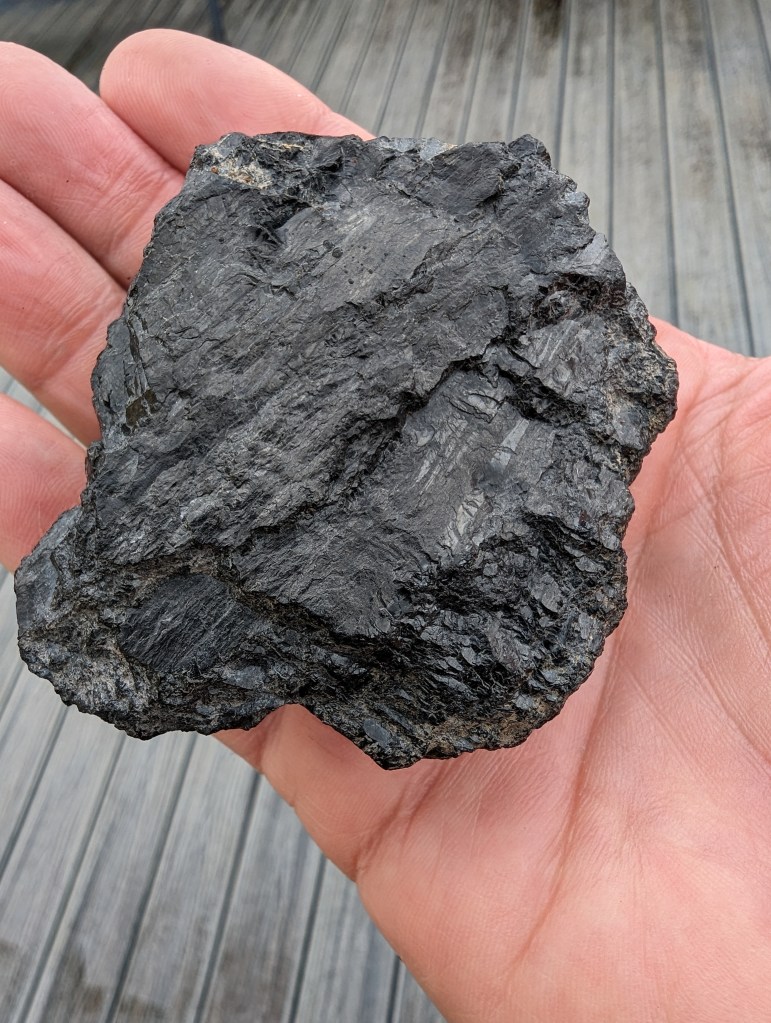
Below: Coal from the Hughes Vein above White Rock. A lustrous black coal that shines like a jewel. You can see the layers of harder vitreous coal that were often the source of better quality fires. The nature of layers in the coal was only finally understood in the early 1900s by Dr Marie Stopes, Britain’s pioneering palaeobotanist.
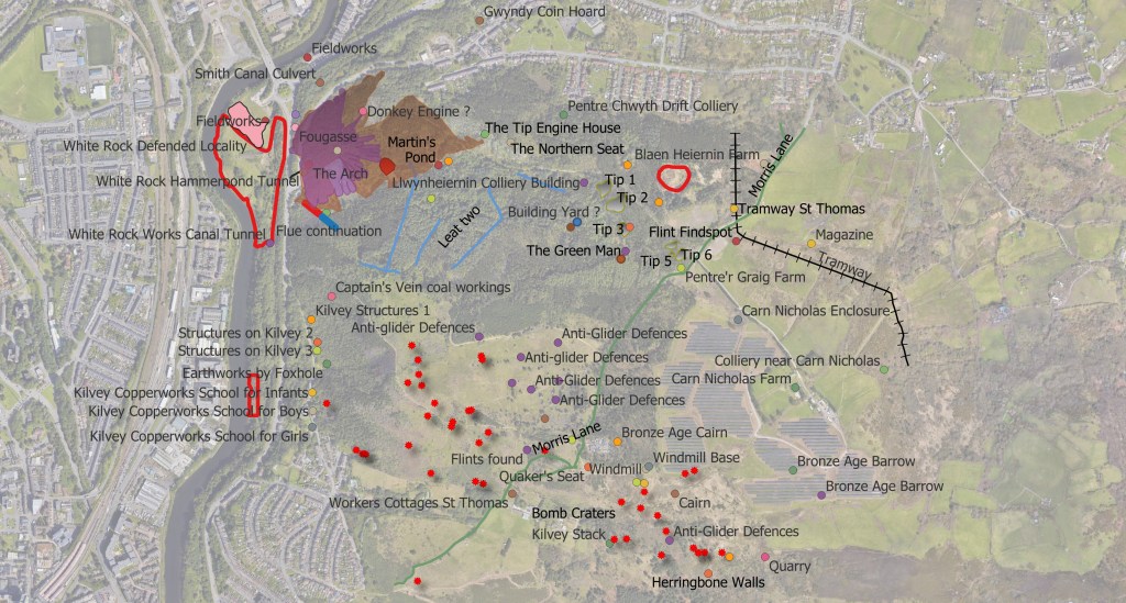
What was on the Archwilio site wasn’t really good enough for us to understand Cilfái, so I redid the surveys. I increased the heritage fetures count on the Hill from 35 to nearer 80. A lot of our Copper, Coal and modern history is not officially recognised by archaeologists…but it doesn’t make it unimportant. You can’t expect historians or achaeologists from elsewhere in England or Wales to understand the significance of our local history and culture. We are forced to do that for ourselves.
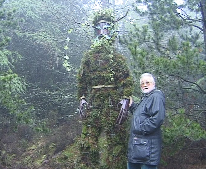
Below: Pete Thomas and Green Man in 1998 shortly after it was completed.
.
Below: A map of some of the heritage features on Cilfái.
You can always contact me to buy the Cilfái books. Send me a message on FB or use WhatsApp or LinkedIn. Or you can email me at my Gmail address. Eye of the Eagle will be available at an illustrated Bo0k Launch talk at Swansea Central Library in early June. I will probably do some talks on the air war over Wales later in the summer.
You can also buy copies of the Cilfái books at the lovely little shop in Swansea Environment Centre. It’s the only shop in Swansea that stocks them.
If you want to buy the books online, the easiest way is to buy them direct from lulu.com because these are the people who print them. In fact if you use Amazon all they actually do is contact lulu. So cut out the middle man and go straight to lulu.
So you can buy Cilfái: Historical Geography on Kilvey Hill, Swansea. This is the history book of the trilogy and it covers the biggest topics in the history of the Hill. So that is Coal, Copper, Pollution, Restoration and Repair and the Nature Recovery. This one also includes Annexes covering the legal background to White Rock Copper Works from 1737, and the Geological history and the pioneering explorations of William Logan. 126pp, fully indexed and referenced.
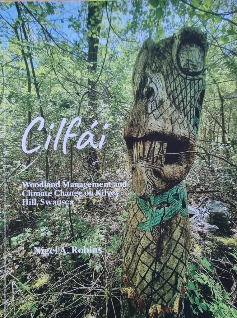
The second book of the trilogy is Cilfái: Woodland Management and Climate Change on Kilvey Hill, Swansea. This one covers the environmental issues faced by the hill and the woodlands. A lot of this one reflects my past government work as a programme reviewer for Defra, DCMS and Historic England, particularly where matters of the environment are concerned. I’m a qualified ecological surveyor and have been involved in a number of large environmental schemes since the 2010s. This book is built around my ecological surveys of the Hill and you will see a lot of Annexes here showing how we create Species and Habitat Action Plans for conservation, My records of everything I found within 1 km of The Glade (between 2010 and 2023) including Mammals, insects, Invasive Species and Reptilees and Amphibians. I also include my Open Mosaic Habitat plant list (including bombsite plants). I have produced a sample copy of a standard Woodland Management Plan to show people how to prepare a good conservation plan and I finish up with my discoveries and monitoring of bat populations on the Hill. This book also has discussions of landscape resilience and climate change issues as we saw them in UK Government.130 pp, fully indexed and referenced.
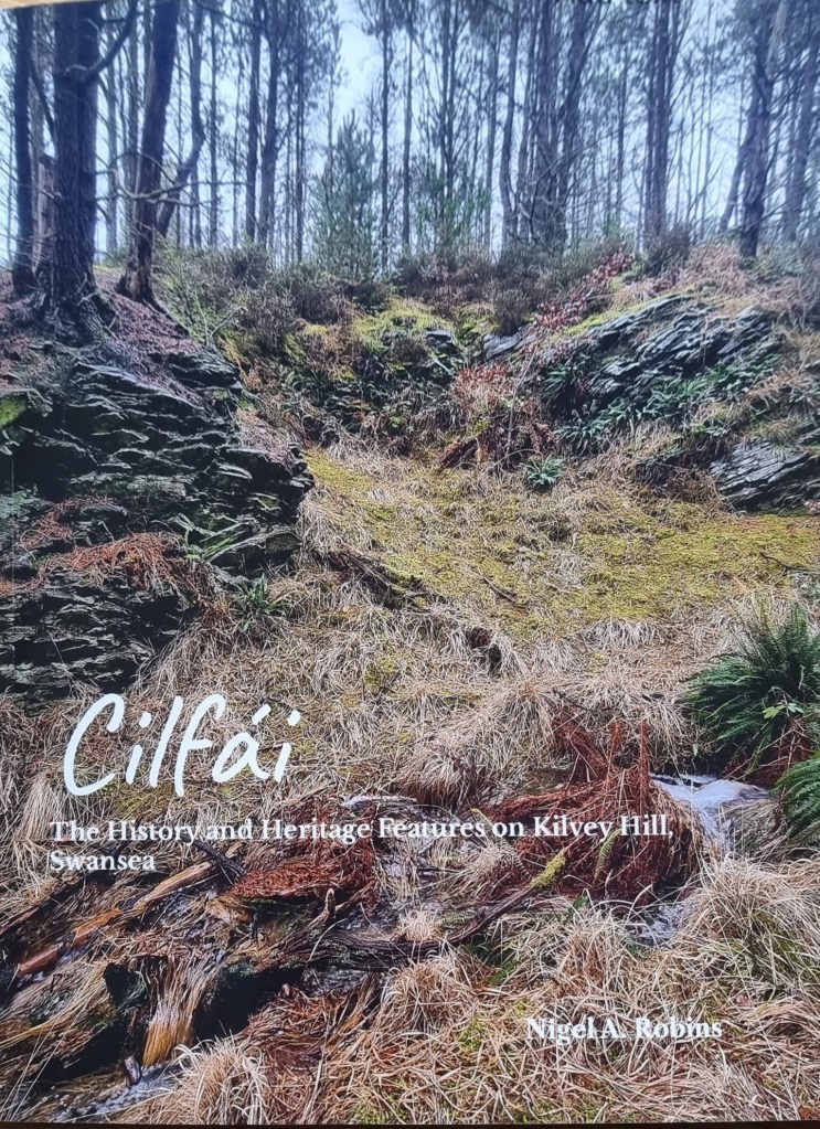
The final Cilfái book is Cilfái: The History and Heritage Features on Kilvey Hill, Swansea. This is based on my new surveys of all the heritage and historic features on the Hill. I spent a couple of years working for UK Parliament, chiefly as a heritage researcher so I picked up al ot of experience working with Parlamentary conservation departments, Historic England and Scottish Heritage. When I reviewed the current records of heritage and archaeology for the hill, I could see they were incomplete or needed updating. This book does that, and I’ve added maps and What3Words locations of all the heritage features on the Hill from the prehistoric sites, coal and copper industries up to the present day with The Green Man. I’ve also added a number of heritage featurews to the list that aren’t on the official lists. All this empasises the point about how special Cilfái actually is.
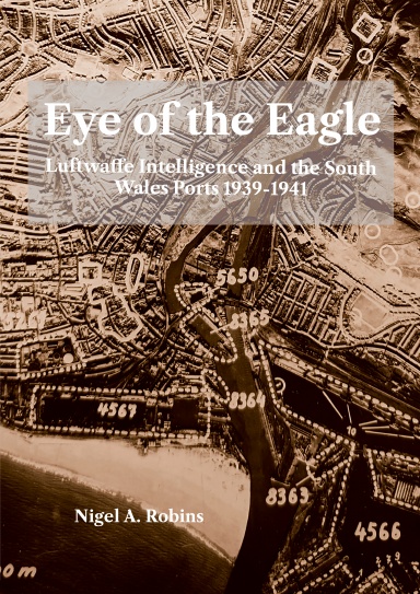
A lot of people know me as a historian specialising in World War Two and my latest book is a revised and much enlarged version of a book I originally published in 1993. Eye of the Eagle: Luftwaffe Intelligence and the South Wales Ports 1939-1941 takes me back to my original research field as a Historical Geographer investigating landscape history. Using Luftwaffe aerial photographs to study Gower landscape sent me in a different direction as I tried to understand the history behind German military intelligence activities in South Wales. Over many years I amassed a large collectionn of Luftwaffe intelligence which portays the reality of the war oiver Wales from the German viewpoint. It also provides a fantastic insight into the activities of the ports of Swansea, Cardiff, Barry and Llandarcy in their finest hour as they supported the nation’s defence and resilience. Using a combination of Luftwaffe intelligence documents and maps and local records from the 1930s, this book examines the reality of why the ports were bombed. A4 size, 170 pp, fully indexed and referenced.
My latest book will cover a bit about the history of the Luftwaffe intelligence of South Wales in the early years of World War Two. It’s been an interesting journey. The records have been mainly in German and it’s been great fun to work with old maps again as opposed to modern GIS systems which have taken up so much of my time looking at Cilfái.
Regardless of how much of a stupid idea it was, the German armed forces were ordered to prepare for an invasion of Britain in 1940. This they duly did in a thorough and orderly way. Some of the documents from that time have survived, although most were destroyed at the end of the War in 1945. I was able to get my hands on a series of Luftwaffe intelligence files and the portfolio of invasion plans of South Wales, which cover in detail why Swansea and Cardiff were bombed. They also show up the gaps in knowledge that often made bombing a waste of lives, money, and time. I can now explain the reasons behind the air attacks on Swansea and Cardiff, and what they were aiming for.
I’ll be doing a series of talks next month to launch the book. I’ll announce them here, but if you want to know more, you can always contact me.
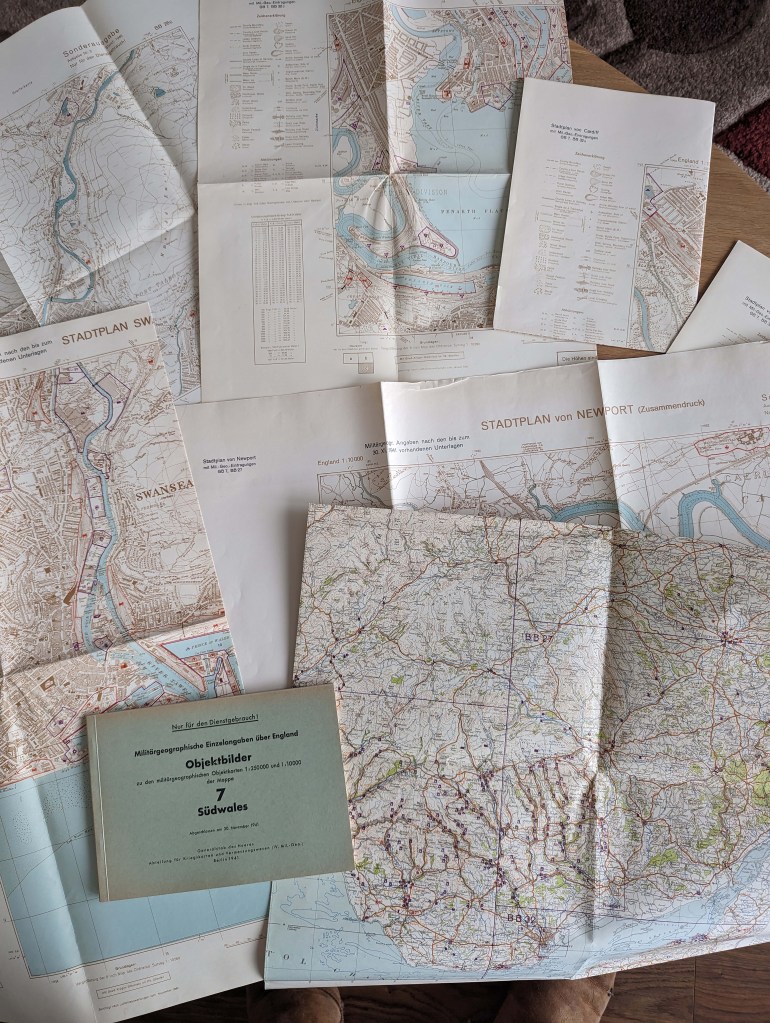
Below: A German military information pack covering South Wales from 1941.
When I worked for the Government, I did some tours of duty in environmental activities. Over the years, I monitored programmes on the health of Honeybees, parks protection in Greenwich’s ancient woodlands, Restoration of the environment in the Olympic site in East London, and several small conservation programmes on security sites for the MOD, where fencing things off from the general public did wonders for the local biodiversity.
In all of that, I learned that data and information are vital. Far too often I heard the comment ‘there’s nothing there!’, often from gentlemen in their fifties whose only interest in nature was how to kill it or cut it down. When I got to a position of some influence, I could slow down or even reverse developments by insisting on a good quality ecological survey before any construction work. Sometimes, this was deeply unpopular as the construction industry usually has little interest in conservation or environmental care…what we see of due diligence by building firms is there because the Law forces them. This will definitely be an issue in Cilfái with the Skyline development. That tourist firm will promise anything in the planning permission stage but quietly ignore it in the building phase, knowing very well that Swansea Council does not have the resources to monitor and enforce anything. We as volunteers will need to monitor the destruction to try and ensure it is kept to the promised minimum.
In December 2022, I prepared the first of a series of ecological protection documents based on my time in Whitehall. The key one is called an Ecological Constraints and Opportunities Plan (ECOP for short). I did one for Cilfái based on what we knew at the time. It proved quite popular and still is, judging from the large number of downloads it still gets from all over the country. Eventually, the ECOP evolved into the second book Cilfái: Woodland Management and Climate Change on Kilvey Hill, Swansea.
I published all my survey notes and plans going back over about ten years of tree and animal survey, including all my work on the Hill. So, the book has an explanation of the data covering the Hill and lists of bats, birds, plants and animals I found or saw presence of. I also included the wonderful observations made by Carl Squires over many years of walking the Hill. I also added some of my Climate Change risk analysis from my time working for UK Parliament.
Below: A mash-up of some of the Cilfái data from my surveys and explorations. It is complex because ecology always is. The red dots are dead or dying trees, the dotted lines and light green stripes are areas for better bird habitat, Yellows and oranges are different types of open land, and darker greens are the Forestry Commission plantation trees. The red lines show the ghost of the coming area of Skyline destruction.
When investigating the history of a landscape, one of the first things worth looking at is the underlying rocks that make up the land. In Wales, this is often the question, ‘Is there coal here?’ In Swansea, the answer is usually ‘yes!’
We can usually get a map showing us the geology of the land. In Swansea, we have the famous Sheet 247 to guide us. As a young student of Geology, my old Dynevor Geology teacher John Rees always told me to ‘get the Memoir’. It was sage advice, and referring to the Memoir is one of the most essential tools in a researcher’s toolkit. Even today, when I read my copy of the Memoir, it comes out in John Rees’ voice and tone in my head—the legacy of an excellent teacher.
The Memoir is the written guide that accompanies every British Geology map. Most were published in the nineteenth or early twentieth century. Whereas the map represents what is under the ground, the Memoir describes in detail all the features and rock types. Swansea’s Memoir was published in 1907 and is a priceless record of years of fieldwork and investigation by a team of accomplished geologists working throughout the 1890s (Strahan 1907). The original work of the Memoir began in the 1830s on Cilfái when pioneer Geologist William Logan taught himself geology by exploring the mines of Cilfái Hill.
The Memoir is a historical record in itself now, as almost all the landscape described has disappeared under housing and tarmac. The Memoir is vital to understanding the geology of Cilfái, and I refer to it many times in Chapter Two of Cilfái: Historical Geography.
Strahan, Aubrey. 1907. The Geology of the South Wales Coal-Field. Part VIII, The Country around Swansea: Being an Account of the Region Comprised in Sheet 247 of the Map, Memoirs of the Geological Survey. England and Wales, 247 (London: Printed for His Majesty’s Stationery Office by Wyman and Sons)
Below: The title page of the Swansea Memoir and below that Swansea as shown on the modern edition of Sheet 247. It still credits the original work by William Logan from the 1830s.
Yesterday (18 April 2024), Swansea Council took a first public step towards leasing or selling a large part of Kilvey Hill to a foreign tourist company. The decision was a milestone in a process started in secret in 2017. The years since have seen covert land assembly, including a particularly unpleasant land steal by Swansea Council, as politicians and staff work officially or otherwise to facilitate the plans of the foreign tourist company.
Our abysmal local government system’s callous, unthinking bureaucratic jargon describes the potential sell-off as a ‘disposal,’ as if the land were used tissue. This had happened before when previous generations and local councils enthusiastically embraced industrial development and regarded the destruction of nineteenth-century Kilvey as merely ‘collateral damage’ … a disposal problem.
The transformation of Swansea from an attractive resort to an industrial black spot was beautifully catalogued in a 1986 book called ‘The Brighton of Wales’ (Boorman 1986). Boorman traces the point of departure from unspoiled beaches to the Lower Swansea Valley industrial magnet. Now, the wheel has turned full circle as a desperate local authority, in acts of unbridled boosterism, refers to Swansea as a world-class tourism destination. I can only assume Councillors haven’t recently made that dangerous walk from Swansea railway station down the High Street.
There will be plenty of economic arguments for the developments to go ahead based largely on optimism and faith in the future. One thing is certain: the enthusiasts for the scheme and all the positive comments on those strange news sites don’t live there.
The Council and the local communities have a lot to be proud of regarding environmental recovery and the new uses of the urban woodlands on the east side. I wish the politicians would recognise this instead of chasing a handful of ice cream-selling jobs.
Boorman, David. 1986. The Brighton of Wales: Swansea as a Fashionable Seaside Resort, c.1780-1830 (Swansea: Swansea Little Theatre Company)
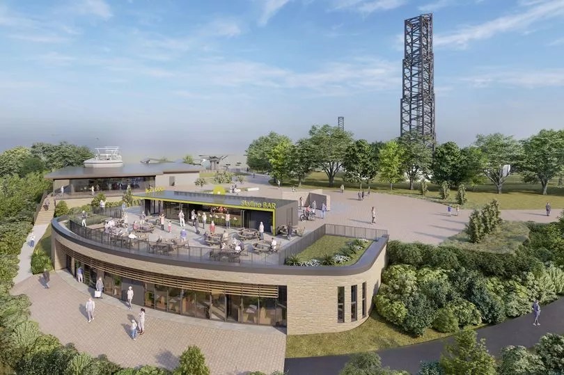
Below: The planned Skyline buildings. Incredibly, this picture is of part of Kilvey Hill that Swansea Council don’t actually own.
Some of you know I spend a lot of time researching the German Air Force (Luftwaffe) intelligence activities over South Wales in World War Two. Eventually, the Luftwaffe bombed several towns, including many attacks on Swansea. The images the Luftwaffe took in preparation for the bombing attacks are often the earliest quality photographic surveys of industrial landscape we have. The main reason I collected such a large archive of photos is because of the landscape history in them. The fact I needed to understand fully the reasons behind the images was just a part of that original journety to understand the records. I’ll be publishing a large book on Swansea and the intelligence war in May. My original Eye of the Eagle book from 1993 is here in PDF.
Anyway, the pictures of the Lower Swansea Valley taken in 1940 and 1941 are an incredible record of the pollution and devastation of the industries in the valley. Eventually, the terrible pollution was ackowledged and a cleanup started in the early 1960s as part of the world-famous Lower Swansea Valley Project. I talk about the Cilfái part in the Project in Chapter Five of Cilfái: Historical Geography .
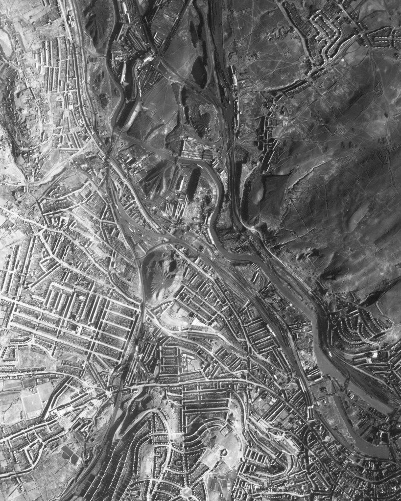
Below is one of the images in my collection from February 1941 when Luftwaffe airmen took photos of the whole town in preparation for the three nights of air attacks between 19 to 21 February 1941. In the middle of this image you can see the massive Hafod tip created by the Vivians industries. Further right are the even larger tips of the valley industries which destroyed the ecology of Cilfái and North-East Swansea. The White Rock tips are just right of centre. I don’t think there is a single tree in the upper half of this image.
The arrival of copper smelting in Swansea changed the nature of industrialisation and transformed the thousand year old coal industry into something new. The redevelopment of Hafod-Morfa and the branding of Swansea Copper as a commodity for tourism involves a lot of verbal gymnastics explaining to new generations and visitors what the copper industry was and why they should be interested in it all. And what it used to look like because it sure as hell doesn’t look like anything now.
It is a tough sell as almost every structure related to the industry was demolished in the twentieth century. The ruins were dirty, dangerous, toxic and were seen as ugly. Fast forward to today when clever marketers will be paid to dress up what is left into a ‘legacy’ tourism…anything is possible with the right amount of ‘Levelling Up’ money. Until it runs out.
Although we have two chimneys and a flavoured whisky business leading the charge to new tourism, there is one legacy of the copper industry that will never be erased…the pollution. I talk of a lot of this in Chapter Three of the Cilfái: Historical Geography book. The copper waste tips of the Lower Swansea Valley were famous on a European scale. most is still there but levelled out and (sort of) grassed over. It continues to inject zinc, cadmium, lead and mercury into the water table.
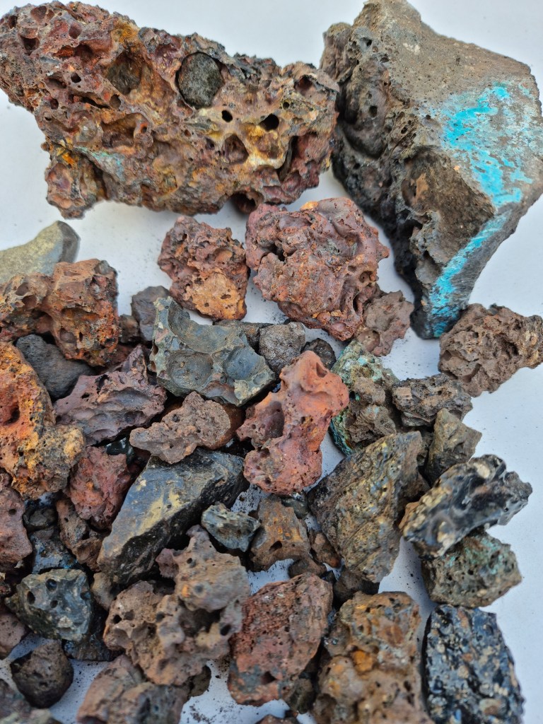
Below: Slag from White Rock will often have the green stain of copper and the remains of the charcoal thrown onto the molten copper at certain times of the smelting process. The nastiest and most toxic tip is right next to the White Rock remains. The waste was thrown on to the meadow of Cae Morfa Carw and the conical pile of waste is like a gravestone over the remains of the pre-industrial landscape.
In the early spring of 1941, two people followed in the footsteps of the bomb disposal teams, firefighters and council workers as they worked through the shattered ruins of Swansea’s blitzed town centre. The first was artist Will Evans, who was keen to document the chaos of ruins and the loss of the heart of the town. Evans left a legacy of vivid watercolours that are well-known. However, the other person was naturalist M. H Sykes, who is less well known. Sykes was a member of the Swansea Scientific and Naturalist Society (SSFNS), and she was a competent botanist with a keen eye.
The ’Three Nights’ Blitz’ inflicted grievous damage on Swansea. The air raids and the ensuing fires created over 16 hectares of broken buildings and rubble at the heart of Swansea. It must have been horrendous.
In 1941, across the country, botanists realised that the blitzed landscapes would soon offer a unique opportunity to witness a comparatively rare phenomenon. This was the emergence of ‘spontaneous vegetation’, the pioneer plants that would arise on the broken brick and rubble. The phenomenon was first recorded amongst the ruins of London after the Great Fire in 1666. In 1941, expanses of ruins reappeared in London and blitzed towns such as Swansea along with the newly christened ‘bombsite flora’.
My article on the bombsite floras of Swansea is forthcoming in the next edition of Swansea History Journal published by the Royal Institution of South Wales http://www.risw.org/publications.htm
Coming soon.
Image: Eliot Hodgkin was one of the very few artists attracted to the contrasts between the brutality of the war ruins and the vegetation that covered them. This is an extract from one of his most notable blitz flora studies of ruins at St Paul’s in London in tempera. Hodgkin was a master of detail and captured the shape and form of many of the blitz plants at their best. The original is in the Imperial War Museum collection.