U-boats in Swansea Bay and Bristol Channel

Starting the new book project. I initially looked at the war diaries of Bristol Channel U-boats back in the 1990s. Research is now easier as more primary records have been released by US archives, at least until the latest President Trump directives close everything down. Modern technology in GIS and GPS has made map research much easier, and I am busy tracking down the original locations of magnetic mines originally planted in Swansea Bay and around the Scarweather Lightship. There have already been a few surprises as the mapping throws up all sorts of questions and new insights into the highly technical war of minelaying and minesweeping in the Bristol Channel.

Starting the new book project. I initially looked at the war diaries of Bristol Channel U-boats back in the 1990s. Research is now easier as more primary records have been released by US archives, at least until the latest President Trump directives close everything down. Modern technology in GIS and GPS has made map research much easier, and I am busy tracking down the original locations of magnetic mines originally planted in Swansea Bay and around the Scarweather Lightship. There have already been a few surprises as the mapping throws up all sorts of questions and new insights into the highly technical war of minelaying and minesweeping in the Bristol Channel.

The war against the U-boats is a complex subject to research thoroughly. There was considerable secrecy on both sides, and very often, the knowledge gap has been filled with wild speculation and inaccurate writing. This means I’ve had to reject a lot of secondary sources that continue to repeat what I’ve learned to call the ‘BBC History’ approach of ruthlessly clever Germans versus plucky eccentric Englishmen. There is also a surprising amount of rivalry and bias between British and US naval sources, both in the 1940s and in the present day. Again, I’ve learned to be scrupulous in testing opinions by viewing primary sources rather than derived history, often from writers who have not worked in the original German language sources.

Above: U28 was one of the Bristol Channel U-boats. This is the boat as she looked just before the war began in September 1939.

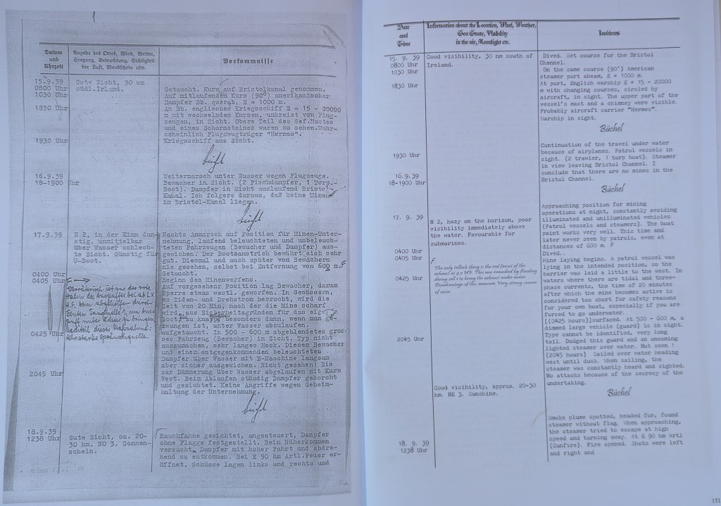
Some initial work was included as an Annexe in ‘Eye of the Eagle’ where I looked at the war diary of U32 as it laid magnetic mines near the Scarweather Lightship in 1939. The new work looks at all the other U-boats that came into Swansea Bay in the early years of the war. Again, it reinforces the crucial role Swansea had in the minds of the German naval staff.

Above: An extract from a U-boat war diary, with my translation. From the Eye of the Eagle book.

More on Swansea coal

I’m still working on the history of geological exploration in and around the Swansea area. Some of it was included in the first Cilfái book, where I wrote about the early work history of William Logan, who learned much of his early geology studying the coal veins of Cilfái.

Knowledge of every coal vein in the area was once the lifeblood of the Industrial Revolution. It is hard to believe now when we can walk through the lush green vegetation of Cilfái without seeing any evidence of the past unless we make an effort to dig to find some.

During our ITV filming on Monday, I was asked about the Tormynydd coal seam. This substantial coal layer, which extends from the seaward side of the hill to Neath and Port Talbot, played a pivotal role in the Industrial Revolution. Like all Cilfái coals, it is bituminous or binding coal that can burn with a cloud of thick black smoke and tends to stick in big lumps when it burns down. (Conybeare and Phillips 1822: 426). The Tormynydd vein is at the bottom of the sketch map and is marked today by a line of big quarries and tunnels across the front of the hill.

My sketch map of the coal veins across Cilfái. It has to be in pencil because I keep updating it as I find more sources and information.

Knowledge of the coal veins of Cilfái and wider Swansea was passed from father to son for generations and it wasn’t until the 1790s that people started to think seriously about understanding the nature and relationship of the underground coal veins.  The first map of coal in the area is William Smith’s map dated 1815 (but based on considerable local knowledge). There’s an extract of it below (Macfarlane 2020).

My sketch plan is based on diaries and memoirs from various times. It is incredible to think that Cilfái had about 10 coal veins providing coal for White Rock and Middle Bank in the 1790s

Above: This is an extract from the earliest map of the local Geology we have. This is dated 1815, but is based on lots of earlier information from the 1700s. This map pre-dates the Ordnance Survey plans for Swansea so gives us a different view of priorities for understanding the main features of Swansea. William Smith had to devise a set of colours to depict the different types of rock (or ‘Strata’ ) that he found. Smith decided on blue to depict limestone…a convention that we still honour today. The grey shading is the ‘coal measures’, the rocks of sandstone and mudstone that contained the precious coal seams (veins in Smith’s time). The fact that Kilvey has a place name shows how important the hill was as a landmark in Swansea’s coal geography. You can see the crosses that mark the location of Swansea’s biggest coal mines at the time of the Napoleonic Wars.

Conybeare, William Daniel, and William Phillips. 1822. Outlines of the Geology of England and Wales: With an Introductory Compendium of the General Principles of That Science, and Comparative Views of the Structure of Foreign Countries … (W. Phillips)

Macfarlane, Robert. 2020. STRATA: William Smith’s Geological Maps, 1st edition, ed. by Oxford University Museum of Natural History (London: Thames and Hudson Ltd)

Swansea 1940, the first Luftwaffe images

The first direct reconnaissance images of Wales were taken on 1 July 1940 from Luftwaffe reconnaissance aircraft taking off from Jersey only hours after they had actually occupied the airport after the surrender off France.

The aircraft was a Do 17P from second Staffel of Fernaufklärungsgruppe 123 Der Adler mit dem Fernrohr,(The Eagle with the Telescope). This image is from that initial mission. The open fields of Mumbles are seen in the fine summer of 1940 with the open lands of the commons on the left side. The wreck of the SS Protesilaus can be seen on the sands at West Cross in the Bay.

Clyne Valley is still intensely wooded and the fields and gardens of western Swansea are still free from the urban density that we see today.