Rosehill Quarry Group, Swansea. Forty years of environmental activism

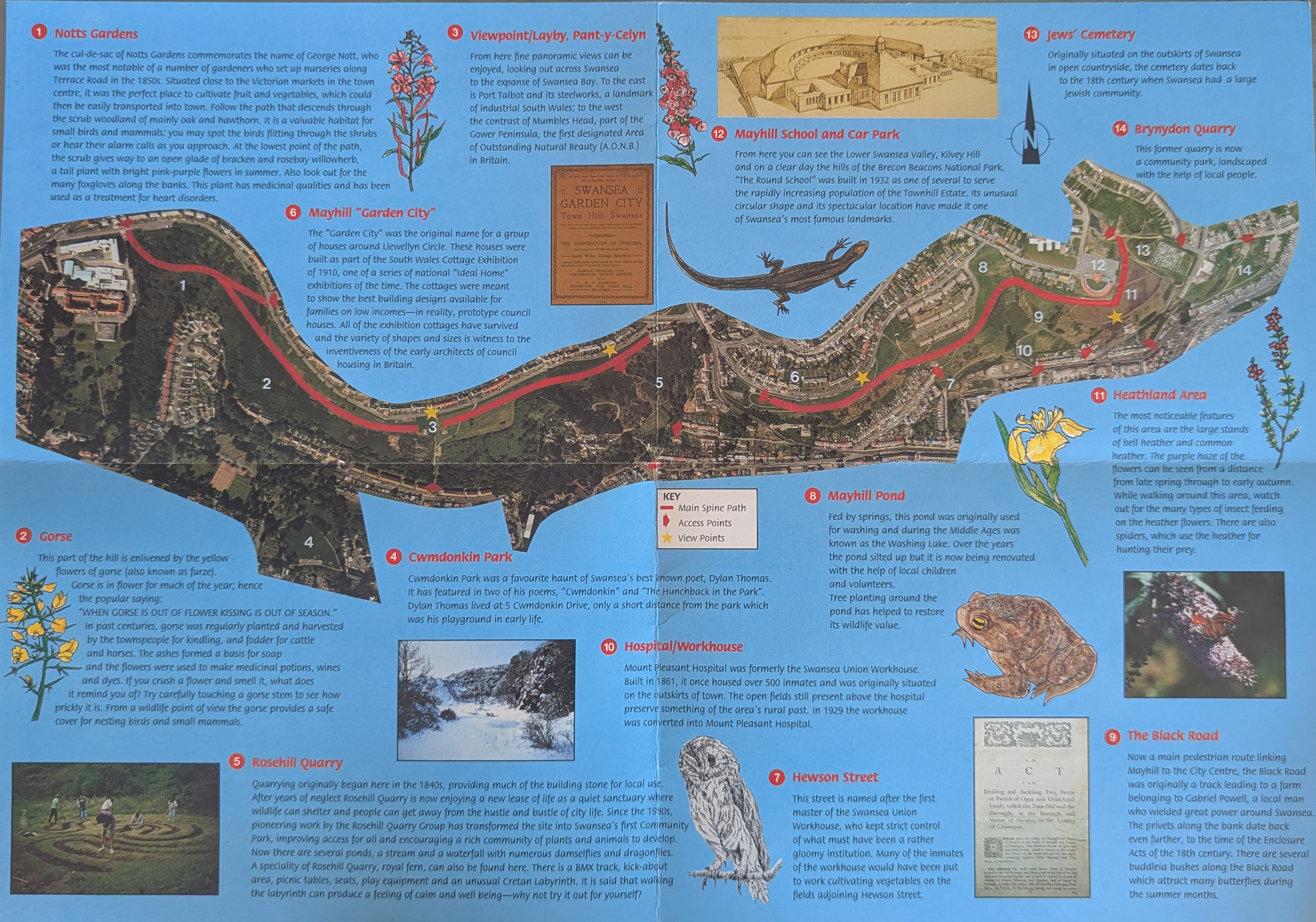
It was good to see the Fortieth Anniversary of the Rosehill Quarry park this afternoon. I remember it being set up as the place was a biodiversity hotspot on the hill long before it was transformed by the Rosehill Quarry  Group. I can remember it wasn’t a completely popular thing to do in the early 1980s, as increasing access to an area known for trouble was not universally welcomed. Four decades later, it looks like it was always there.

Above: Rosehill’s recent Green Flag at the Fortieth Anniversary of the Group on Sunday 7 September 2025.

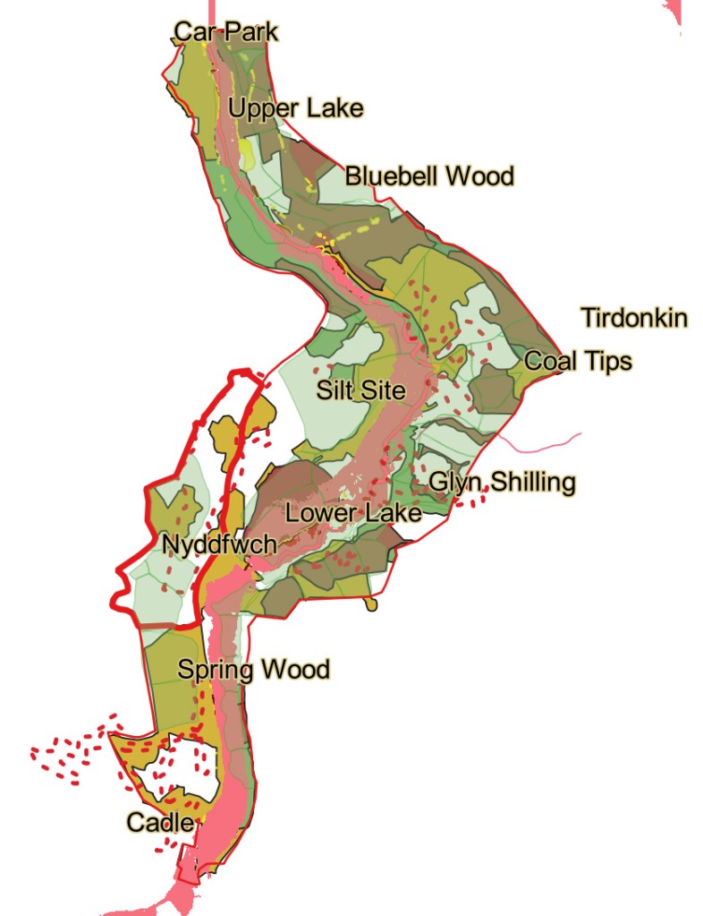
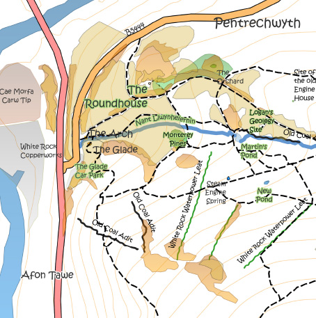
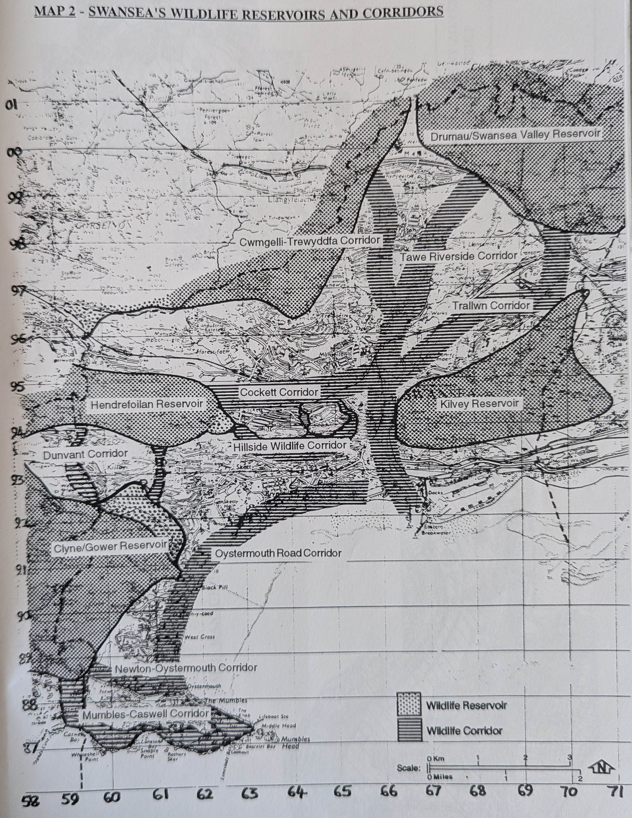
I remember writing the notes for a publicity pamphlet some years later when the City Council rebranded the area as the ‘Hillside Wildlife Corridor’  as part of the 1990 landmark Strategy for Greening the City. In those days, Swansea was zoned into a series of wildlife corridors and wildlife reservoirs. With bitter irony for what is about to happen, Kilvey was recognised as a wildlife reservoir.

It was particularly good to see Councillor D. H Hopkins say a few words about Rosehill, as he was central to the setting up of the Wildlife Corridor in the 1990s. He was far too modest about his role, and for me at least,  he brought a welcome sense of continuity as if to confirm the long commitment to creating and maintaining the green space. For my part, I often gave little history talks about the area to the Group in the early days, always tempted by the fabulous cakes that Margaret Burdett would bring to the meetings.

Above: The 1990s understanding of wildlife corridors and reservoirs. This work originated in the 1999 ‘Greening the City’ discussions. Swansea is remarkably fortunate in having so many formal and informal green spaces. Political agendas and constrained funding mean that the security of many of them is always precarious.

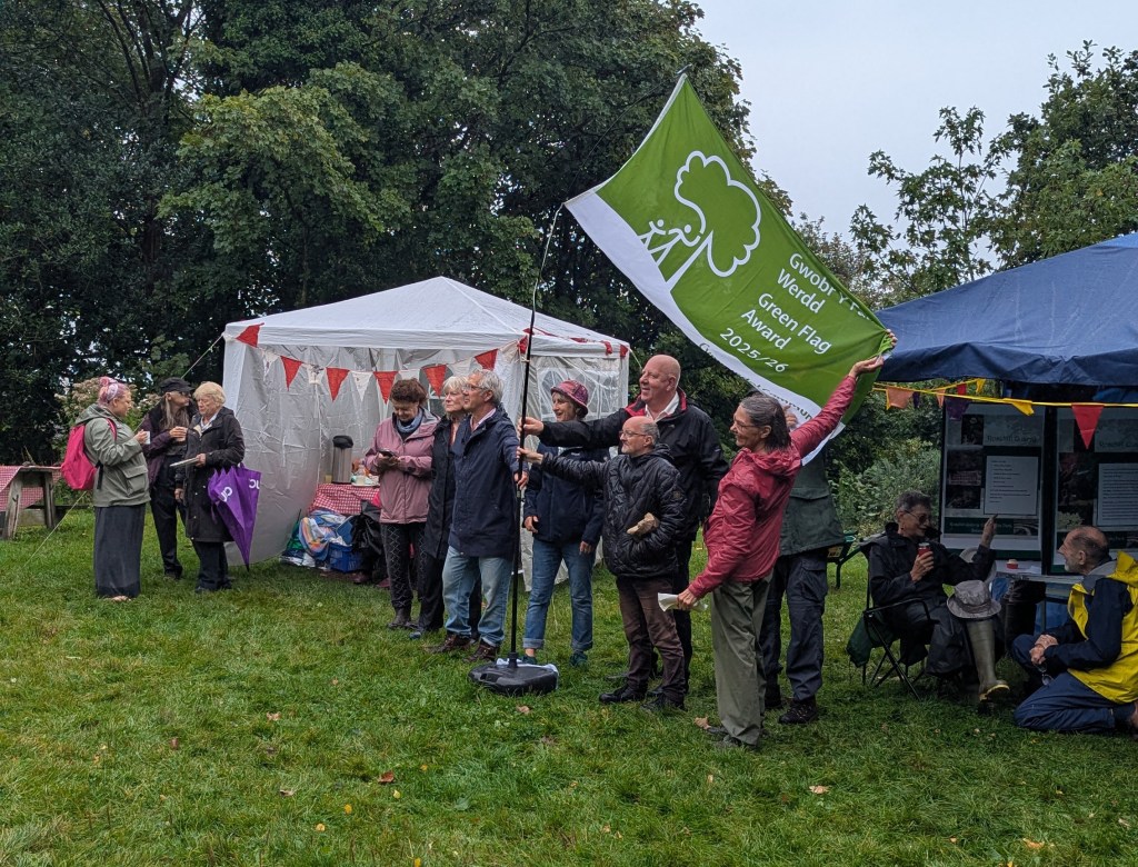
I think it is also the tenth year the site has been awarded a Green Flag. On Kilvey, we had our first Green Flag this year.

Rosehill has always had unfailing political support from the Council (both City and its successor County Council). The area has transformed into a green jewel for plants and wildlife, and both the Council and the new crop of volunteers have done a fantastic job. One day, I hope Kilvey will get such good political support.

Among about thirty people there, I only recognised one face. A new generation of people has taken over, which made me feel rather old.

Above: The 1990s leaflet for Rosehill, and the Townhill Wildlife Corridor (1994). These were derived from my notes from the research project for the Enclosure of Townhill book. My suggestion was that the original hedgerow banks were replanted with hawthorn, as they would provide texture and contrast with the rest of the plantings for future generations. The Planning Department never took the time to understand me. (Matthew 7.6).

Values, Significance, Attributes, and Authenticity: Leveraging the best of IUCN Guidance

I was particularly struck by a recent opinion piece in The Lancet Planet Health on the links between human health and wellbeing and diverse nature.2 It’s an approach that remains at the centre of my use of Kilvey/Cilfái as a landscape for teaching. Early on, I could see that an overemphasis on biodiversity to the exclusion of other aspects of the environment would inevitably lead to a partial appreciation of the landscape.

Subscribe to continue reading

Subscribe to get access to the rest of this post and other subscriber-only content.

A new orchard survey for Swansea and Gower

I’m just about to begin a data refresh of our local traditional orchard database. My original work was in 2012 as a contribution to the England and Wales survey that collected a massive amount of data about surviving orchards. For ~Swansea and Gower,  that original data is now outdated and in need of revision. This is particularly significant for the Gower National Landscape (formerly the AONB).

I’m just about to begin a data refresh of our local traditional orchard database. My original work was in 2012 as a contribution to the England and Wales survey that collected a massive amount of data about surviving orchards. For ~Swansea and Gower,  that original data is now outdated and in need of revision. This is particularly significant for the Gower National Landscape (formerly the AONB).

Above: A culinary apple crop from a tree that is over a century old in Swansea, August 2025.

Back in 2012, it was a hot summer, and I remember walking North Gower roads and lanes, ground-truthing previously identified potential survivals from satellite photos. It will be interesting to see what has changed. Originally, the oldest trees I saw in my surveys were culinary or cooking varieties, as in previous centuries, most apples were cooked in various forms in cakes, puddings, pies, pasties, and even soups. I saw dessert varieties start to appear as transport links to bigger markets became easier. The orchards of Northern Gower seem to have their origins in the arrival of the railway, allowing trouble-free transport to Llanelli and Swansea.

Although some academics have suggested that it is very rare to see apple trees older than a hundred years, I felt this may need correction, as I have seen some trees that, because of their location and size, are older than assumed. Much of Glamorgan’s apple industry was irreversibly damaged by massive imports of cheap Canadian apples via Cardiff and Swansea in the 1920s. The industry never recovered. In more recent decades, I see younger trees of dessert apples as people want to plant something easily consumed, and the recipes and practices of handling cooking apples have fallen out of fashion.

Equally, a new generation of consumers equate apples to cider, and I’d expect to see some ambitious investment in recently planted trees for juicing and cider.  However, the data I collect will confirm the picture.

Above: Gower orchards from the 2012 data. This is mixed with historical house data. There may possibly be a loose correlation between the two, although much altered by subsequent property development. Something to investigate!

Biodiversity and Bomb Craters

The Kilvey bombed landscape is unique in Wales, although bombs were dropped across the Welsh ports between 1940 and 1943, ther survival of any traces is rare. Several shrapnel-scarred buildings remain in Swansea, and a similar situation exists in other European towns and cities. What is unique in Wales is the survival of a landscape with craters that has been allowed to recover or develop naturally.

A look at the biodiversity contribution of the World War Two bomb craters on Cilfái.

I’ll be leading a couple of walks up the top of the hill soon. This year, I’m intent on looking at biodiversity and heritage. The bomb-damaged landscape of Kilvey Hill is now 84 years old, and a lot of it has survived or avoided being bulldozed, as often happens. Ironically, the heritage landscape of the Hill may soon be destroyed by Swansea Council as part of their Skyline tourism obsession.

The Kilvey bombed landscape is unique in Wales, although bombs were dropped across the Welsh ports between 1940 and 1943, the survival of any traces is rare. Several shrapnel-scarred buildings remain in Swansea, and a similar situation exists in other European towns and cities. What is unique in Wales is the survival of a landscape with craters that has been allowed to recover or develop naturally.

Many of you will know of my interest in bombsite botany via my lectures and articles, and one of the chapters in my book on the Three-Nights’ Blitz. Although formed in horrible acts of violence, the Kilvey bomb craters have been transformed by nature into essential wildlife refugia. Some hold small ponds, others are havens of warmer temperatures and protection from the wind, or even fire. The combustion of chemical explosives would have made the craters poisonous after their creation, and of course, the land is peppered with bomb fragments, which have become part of the archaeology of the hill. Nearly a century later, the craters have taken on a new role as centres of plant and wildlife.

I’ll explore this incredible mix of heritage and ecology on a couple of walks. I’ll advertise via Eventbrite, and I’ll let you know here as well.

Above: One of the Kilvey bomb craters with a small mire. June 2025.
A photo-generated 3D model of one of the Kilvey bomb craters, March 2025.

Cilfái/Kilvey

I’ve now completed the information project for the Cilfái/Kilvey Hill landscape and surrounding area. The three books covering history, environment, climate change and heritage have all done phenomenally well. I’m sure that almost everyone who wanted copies of any or all of the books in the trilogy now has them. I remain amazed at the level of interest from the USA, Canada, and Australia!

I’ll be teaching Cilfái in several local places in 2025 alongside my World War Two books on South Wales and Swansea Blitz. I will also be offering open-air classroom sessions up on the Hill when the weather allows me to! I’ll post those details in the New Year.

I still have no idea about the future of the Hill, and I guess Swansea Council’s threatened destruction of the environment is about to enter the next phase in 2025. Meanwhile, I’ll continue to use the Hill and/or what survives of the woodlands as my outdoor classroom. A wonderful environment to examine heritage, climate change, woodland biodiversity and geology.

Interest in the history and geography of Cilfái continues to rise, and I’d like to thank the many educational (FE and HE) establishments and organisations for their continued support and engagement with me (and the outstanding Kilvey Woodland Volunteers) in seeking to understand the hill’s value for our local communities and as an educational and wellbeing resource.

One of the fascinating backstories of Cilfái has been the significance of the Hill in the history of coal exploration. Swansea has a particularly special place in the history of the British coal industry. Much of that rich history has been forgotten or discarded, but my next book will be about bringing that fantastic history back to life.

The Cilfái Trilogy. Bringing the uniqueness of the Hill to a wider audience!

Penllergare: The Ancient Trees

The latest press release from Welsh Government about the National Forest for Wales confirmed that Swansea’s Penllergare Valley Woods has been confirmed as a National Forest site. I think this makes it one of the hundred announced sites so far.

It is a clever bit of policy from Welsh Labour and throws a bit of recognition and identity branding the way of some struggling woodland sites. Creating a Welsh ‘network’, however fragmented, can only be a good idea.

The pre-medieval road to Nyddfwch in the Penllergare Valley Woods in 2018.

The name of Penllergare is as confusing as its location. It is probably an anglicisation of nearby Penllergaer. The lottery-funded restoration project adopted the name from the long-gone mansion owned by the Llewelyn family. The awkward anglicisation always makes me uncomfortable and I tend to refer to the area as the Llan Valley or Nyddfwch which were earlier locality names and are far more in keeping with modern sensibilities.

Above: The Penllergare woodlands are a complex mix of ancient woodland, garden planting, invasive non-natives and coal mining archaeology. An incredibly rich mix of history and environmment.

The valley woodlands thoroughly deserve inclusion in the National Forest list. I spent nearly ten wonderful years surveying and researching the landscape and woodlands until I felt compelled to leave in the face of the ugly politics and personalities that run the charity. Some of the staff and volunteers I worked with were some of the finest people I ever experienced in conservation circles, although all have been hounded out by the organisation, which is such a shame.

The original mission of the lottery-funded project was to recreate the nineteenth-century estate gardens of the Llewelyn family. It was centred on making something of the remaining walled garden and the paths and planting of the Llewelyns, a wonderful collection of exotic trees, native (1800s) planting, and a collection of Rhododendrons. The premise was ambitious in the early 2000s, and many of us were surprised that it got funding, as we knew the concept was challenging because of climate change and the lack of surviving substantive features. I think the charity running the place is now pressing for more money to keep the place going. Some of you who came to my Environment Centre lectures may remember I compared the limited effectiveness of money invested in Penllergare with the far better return on investment of money spent on Cilfái.

Above: The Nyddfwch Oak in Penllergare.

The wider area of woodland contains significant ancient trees, 1950s Forestry Commission planting and a spectacular collection of unusual and exotic tree species (the remnants of the nineteenth-century garden). Much is made of the links to the Llewelyn family, although they abandoned the site for a nicer house elsewhere. I imagine the family’s estate managers will be unhappy at this latest National Forest status as they were hell-bent on selling for housing; the land is on a short lease for the charity.

Above: Ancient tree stumps from the Penllergare valley. The area was cleared for timber in the 1940s although many trees and ther carcasses survive providing an excellent reservoir of dead wood. At one time the management wanted to sell the wood for firewood LOL.

The history of the nineteenth century is only of limited significance. Far more interesting is the history of the valley in the early 1700s, when it was devastated by coal mining. So, the land is a good example of early Welsh industrialisation and the recovery after that, when the coal was worked out in the 1790s. The ancient trees are an incredible survival from the coal mining devastation of the 1700s and were probably rejected for harvesting as timber because of their shape. I prepared a draft book on the woodlands a few years ago, and now may be the time to turn it into a real entity.

I used to take many groups into the woods to explore the woodland, let me know if you’re interested and I’ll put together a walk.

Above: My original manuscript. Maybe I’ll make it real.

Cilfái: The Principles of Diversity and Resilience

Cilfái’s connectivity to other wildlife and natural habitats is not just a concern, it’s a massive issue. The dangerous main roads dominate the wider extent, west towards the river and north towards what was the Enterprise Zone. Within the woodlands, further development for bike paths, walking trails and cable car routes are all immediate risks for ruinous fragmentation. The width of paths and firebreaks and cableways and how we manage the woodland edge habitats are crucial. Cilfái’s wider nature network must be urgently mapped and managed using the ten well-known best practice principles (Crick and others 2020a: 91–101).

1. Understand the Place. Understanding the community and the natural networks that are in place.

2. Create a Vision. Create a future that is understandable and engages the biggest stakeholders, usually the local communities, animals and plants, and those responsible for caring for and maintaining the land.

 3. Involve People. Communication, engagement and consultation are tremendously important. Do we see that commitment from local politicians?

4. Create Core Sites. The central Cilfái woodland is our core site.

5. Build Resilience. This is protection against climate change-related events such as drought, torrential rain, wildfires, and temperature extremes. I describe some of these in the book.

6. Embrace Dynamism. Nature changes constantly. Change can happen in a matter of minutes: a tree blows down, a stream bursts its banks, or a rockfall changes the shape of the land. We can’t keep spending money on keeping things ‘as they are’. Is expensively recreating a nineteenth-century landscape that relies on money, gardening, water and stable weather and climate  (as they do at Penllergare Country Park) even possible in the modern world? We must accept and adapt to our situation, not the situation we would like to be in.

7. Encourage Diversity. There is genetic variabilityspecies diversityecosystem diversity and phylogenetic diversity. Diversity is not distributed evenly on Cilfái. The ecosystem we see building on the hill results from 50 years of growth and change.It should be allowed to develop naturally. The notion that a local Council or a private tourism company can care for the land is an outrageous conceit.

8. Think ‘Networks!’ Plants, animals, and people move and live in connected networks.

9. Start Now, but Plan Long-term. Short-term is about 3 years, long-term is about 50 or more. Nobody knows what the world will be like in 50 years.

10. Monitor Progress. We can’t understand change if we don’t observe it constantly. A 3-day ecological survey by a non-local contract ecology firm on behalf of a foreign tourist company doesn’t cut it.

However, there will always be uncertainty about what Cilfái can contain because it is always prone to extreme disturbance.

Crick, H.Q.P., I.E. Crosher, C.P. Mainstone, S.D. Taylor, A Wharton, and others. 2020. Nature Networks: A Summary for Practitioners (York: Natural England)

Above: The western part of the woodland with areas of particular attraction to birds and wildlife highlighted in shades of Brown. These areas are open or semi open and also show strong characteristics of ‘woodland edge’ or ‘Stand A’ structures (see Annex 7). These areas have their origin in polluted soils from slag tips or fire damage from wildfire attacks. The old coal adits and leats provide damper cover than the surrounding woodland and frequently act as biodiversity hotspots because they retain moisture in drought conditions. These Brown areas are the current centres of natural regeneration. The woodland cover in these areas will not be necessarily native species, it is far more likely to be the ‘Cilfái mix’ of coniferous, native and invasive non-native. These areas are rapidly becoming reptile hotspots and also very strong presences of foraging bats.
 

Woodland Resilience

I talk about ‘Resilience’ in Chapter Three of the second Cilfái volume.

The term ‘resilience’has become a key concept in our landscape management. Resilience in woodland is becoming a broader and more important topic as climate change starts to bite.

In its current form, Cilfái is resilient. Yes, people burn it every year, but that results in more biodiversity hotspots as the burnt patches grow back with local species of trees and vegetation that are much more resilient to fire and drought.

Anything done to the woodland should be to enhance resilience…not knock it back with imported plants, plastic tree tubes and high maintenance planting schemes.

Diversity in the Cilfái woodlands can range froim genes and species to habitats and landscapes. The complexity of the Cilfái woodlands ecosystem will always be limited compared to a woodland that is older or has not been polluted. Still, the pollution history of the hill makes the ecosystem special and probably even unique.

Above: The seaward slopes of Cilfái are increasingly susceptible to windstorms which easily topple the trees that often have poor anchorage because of the soil conditions. The resulting deadwood (both prone and standing) provides useful food and shelter for many animals and insects. The natural regeneration quickly takes over a windblown space and colonises fast with the ‘Cilfái mix’ of local species. Incredibly, this site on the proposed tourism development is a bat hotspot. (Author’s collection).

Bats over Cilfái

One of the reasons we know so little about the abundance or distribution of bats is the general technical difficulty of surveying and recording where they live and where they hunt. Nationally, the effort to monitor the bat population is significantly bolstered by the invaluable contribution of volunteers. Their dedication, although often underappreciated, plays a crucial role in our understanding of bat populations. However, this reliance on volunteer work, while commendable, is not without its challenges. The situation is further complicated by the need for specialized equipment and training. Although bat surveys have become a regular requirement for planning permission, the surveys remain expensive and knowledge is considered commercial and rarely shared, making understanding of bat distribution even more complex. Using specialist recording equipment means the data files for bat surveys can become very large very quickly, although the advantage is that the data is available for further analysis and verification.

I trained as a bat surveyor in the Thames Valley, where University researchers waxed lyrical about the high densities of bats along the river. One warm night we went out and didn’t detect a single one. That has never happened to me on Cilfái, where bat presence can be staggering on many nights.

Bat surveys have become high cost as surveyors seek to extract as much income from the work as possible. It is unfortunate, as much needed information then becomes restricted or unshared. That greedy attitude led me to share as much as I have on the bat presence on the hill in the second Cilfái book. Cilfái: Woodland Management and Climate Change on Kilvey Hill, Swansea.

On Cilfái, I use a combination of a handheld detector and automatic recorders, which give me a sample of several nights at various locations. This lets me hear the bat calls as they hunt and analyse the recordings at home. I use the classic handbook for techniques Jon Russ wrote (Russ 2012). I use Anabat Express (or equivalent) passive bat recorders and process the data with Anabat Insight Version 2.  Over time, this gives me an understanding of the ‘hotspots’ of activity across the hill. I only get snapshots of what is happening, and I cannot realistically project what I know into the overall picture of bats on the hill. That will take a few years. I can assume that our ‘Year Zero’ in 1970 had no bat presence and that everything I see and hear in 2023 is the product of fifty years of recovery. However, realistically, the woodland only began its recovery in the mid-1990s.

The hotspots on the hill are where the food is. Generally, these are the open spaces where previous burning or wind damage has opened up the forest canopy and allowed a wider range of native plants to prosper. Some of these open spots are also good for birdlife. On a warm autumn evening, the air in the hotspots is thick, and flying insects attract the bats. I have evidence of a large presence of Common Pipistrelle (Pipistrellus pipistrellus) and Noctule (Nyctalus noctula). It is possible that hidden in my recordings is some evidence of the Brown long-eared bat (Plecotus auritus), only further data collection will confirm.

Although I can track and monitor activity, it remains immensely difficult to understand hibernation and roosting sites. I am slowly building up a library of bat presence data across the hill.

Russ, John. 2012. British Bat Calls: A Guide to Species Identification (Exeter: Pelagic).

Below: Although it looks a bit technical, it is the nature of bat survey work that we prepare this kind of evidence. The land above Foxhole and the Glade is very busy with bats and clearance of trees will definitely cause problems for the population that has re-established up there. On the night this recording was made I had hundreds of similar records. You can see more evidence in the Cilfái book.

This is a recording of a Common pippistrelle hunting on the woodland edge above Foxhole in September 2023. Temperature above 20 Celsius (Analook F7) compressed with split-screen option Cycles, showing the characteristic call shape of a hunting pippistrelle.

Below: Me bat surveying on the threatened land above Foxhole September 2023

Saving the Environment: The importance of Information

When I worked for the Government, I did some tours of duty in environmental activities. Over the years, I monitored programmes on the health of Honeybees, parks protection in Greenwich’s ancient woodlands, Restoration of the environment in the Olympic site in East London, and several small conservation programmes on security sites for the MOD, where fencing things off from the general public did wonders for the local biodiversity. In all of that, I learned that data and information are vital. Far too often I heard the comment ‘there’s nothing there!’, often from gentlemen in their fifties whose only interest in nature was how to kill it or cut it down. When I got to a position of some influence, I could slow down or even reverse developments by insisting on a good quality ecological survey before any construction work. Sometimes, this was deeply unpopular as the construction industry usually has little interest in conservation or environmental care…what we see of due diligence by building firms is there because the Law forces them. This will definitely be an issue in Cilfái with the Skyline development. That tourist firm will promise anything in the planning permission stage but quietly ignore it in the building phase, knowing very well that Swansea Council does not have the resources to monitor and enforce anything. We as volunteers will need to monitor the destruction to try and ensure it is kept to the promised minimum. In December 2022, I prepared the first of a series of ecological protection documents based on my time in Whitehall. The key one is called an Ecological Constraints and Opportunities Plan (ECOP for short). I did one for Cilfái based on what we knew at the time. It proved quite popular and still is, judging from the large number of downloads it still gets from all over the country. Eventually, the ECOP evolved into the second book Cilfái: Woodland Management and Climate Change on Kilvey Hill, Swansea. I published all my survey notes and plans going back over about ten years of tree and animal survey, including all my work on the Hill. So, the book has an explanation of the data covering the Hill and lists of bats, birds, plants and animals I found or saw presence of. I also included the wonderful observations made by Carl Squires over many years of walking the Hill. I also added some of my Climate Change risk analysis from my time working for UK Parliament. Below: A mash-up of some of the Cilfái data from my surveys and explorations.  It is complex because ecology always is. The red dots are dead or dying trees, the dotted lines and light green stripes are areas for better bird habitat, Yellows and oranges are different types of open land, and darker greens are the Forestry Commission plantation trees. The red lines show the ghost of the coming area of Skyline destruction.