
Subscribe to continue reading
Subscribe to get access to the rest of this post and other subscriber-only content.
I was particularly struck by a recent opinion piece in The Lancet Planet Health on the links between human health and wellbeing and diverse nature.2 It’s an approach that remains at the centre of my use of Kilvey/Cilfái as a landscape for teaching. Early on, I could see that an overemphasis on biodiversity to the exclusion of other aspects of the environment would inevitably lead to a partial appreciation of the landscape.
Subscribe to get access to the rest of this post and other subscriber-only content.
I’m still working on the history of geological exploration in and around the Swansea area. Some of it was included in the first Cilfái book, where I wrote about the early work history of William Logan, who learned much of his early geology studying the coal veins of Cilfái.
Knowledge of every coal vein in the area was once the lifeblood of the Industrial Revolution. It is hard to believe now when we can walk through the lush green vegetation of Cilfái without seeing any evidence of the past unless we make an effort to dig to find some.
During our ITV filming on Monday, I was asked about the Tormynydd coal seam. This substantial coal layer, which extends from the seaward side of the hill to Neath and Port Talbot, played a pivotal role in the Industrial Revolution. Like all Cilfái coals, it is bituminous or binding coal that can burn with a cloud of thick black smoke and tends to stick in big lumps when it burns down. (Conybeare and Phillips 1822: 426). The Tormynydd vein is at the bottom of the sketch map and is marked today by a line of big quarries and tunnels across the front of the hill.
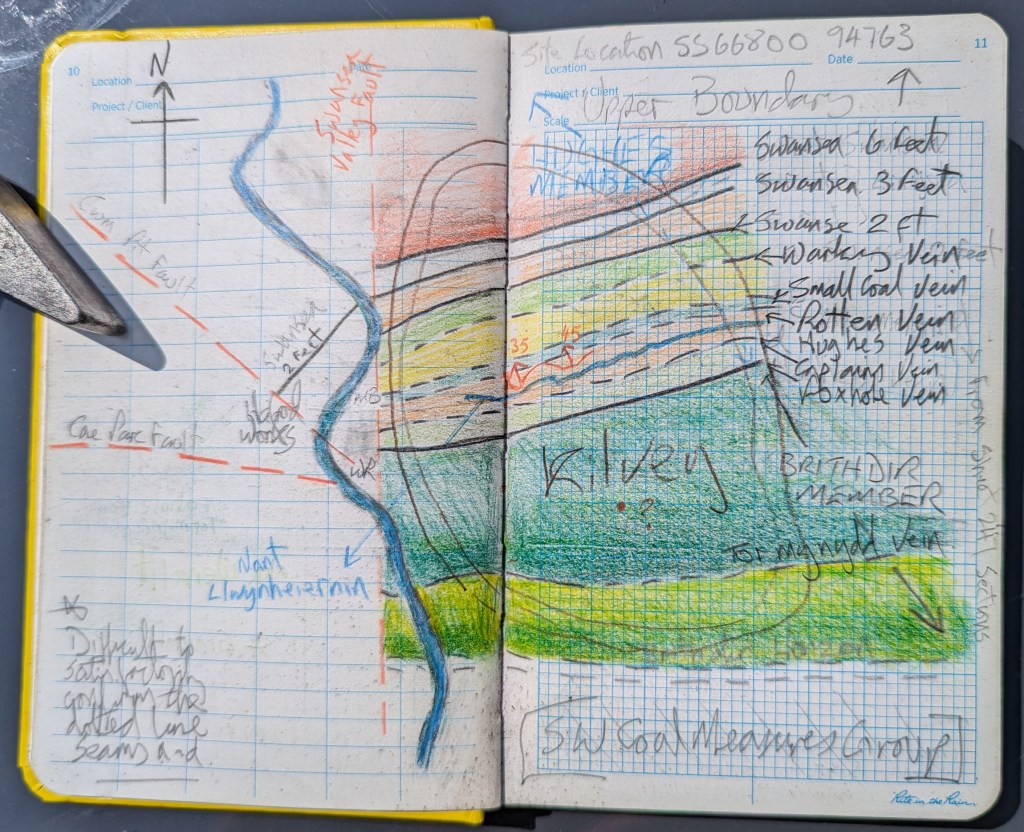
Knowledge of the coal veins of Cilfái and wider Swansea was passed from father to son for generations and it wasn’t until the 1790s that people started to think seriously about understanding the nature and relationship of the underground coal veins. The first map of coal in the area is William Smith’s map dated 1815 (but based on considerable local knowledge). There’s an extract of it below (Macfarlane 2020).
My sketch plan is based on diaries and memoirs from various times. It is incredible to think that Cilfái had about 10 coal veins providing coal for White Rock and Middle Bank in the 1790s

Conybeare, William Daniel, and William Phillips. 1822. Outlines of the Geology of England and Wales: With an Introductory Compendium of the General Principles of That Science, and Comparative Views of the Structure of Foreign Countries … (W. Phillips)
Macfarlane, Robert. 2020. STRATA: William Smith’s Geological Maps, 1st edition, ed. by Oxford University Museum of Natural History (London: Thames and Hudson Ltd)
When investigating the history of a landscape, one of the first things worth looking at is the underlying rocks that make up the land. In Wales, this is often the question, ‘Is there coal here?’ In Swansea, the answer is usually ‘yes!’
We can usually get a map showing us the geology of the land. In Swansea, we have the famous Sheet 247 to guide us. As a young student of Geology, my old Dynevor Geology teacher John Rees always told me to ‘get the Memoir’. It was sage advice, and referring to the Memoir is one of the most essential tools in a researcher’s toolkit. Even today, when I read my copy of the Memoir, it comes out in John Rees’ voice and tone in my head—the legacy of an excellent teacher.
The Memoir is the written guide that accompanies every British Geology map. Most were published in the nineteenth or early twentieth century. Whereas the map represents what is under the ground, the Memoir describes in detail all the features and rock types. Swansea’s Memoir was published in 1907 and is a priceless record of years of fieldwork and investigation by a team of accomplished geologists working throughout the 1890s (Strahan 1907). The original work of the Memoir began in the 1830s on Cilfái when pioneer Geologist William Logan taught himself geology by exploring the mines of Cilfái Hill.
The Memoir is a historical record in itself now, as almost all the landscape described has disappeared under housing and tarmac. The Memoir is vital to understanding the geology of Cilfái, and I refer to it many times in Chapter Two of Cilfái: Historical Geography.
Strahan, Aubrey. 1907. The Geology of the South Wales Coal-Field. Part VIII, The Country around Swansea: Being an Account of the Region Comprised in Sheet 247 of the Map, Memoirs of the Geological Survey. England and Wales, 247 (London: Printed for His Majesty’s Stationery Office by Wyman and Sons)
Below: The title page of the Swansea Memoir and below that Swansea as shown on the modern edition of Sheet 247. It still credits the original work by William Logan from the 1830s.


