The Luftwaffe surveys of the Welsh ports are an incredible record of past landscapes that have now changed. Although the intent of the reconnaissance missions was to prepare for the bombing of the South Wales ports in 1940 and 1941, they also recorded some of the earliest and finest detail if the coastal landscape. Many of the best surviving images are explained and interpreted in Eye of the Eagle: Luftwaffe Intelligence and the South Wales Ports 1939-1941.
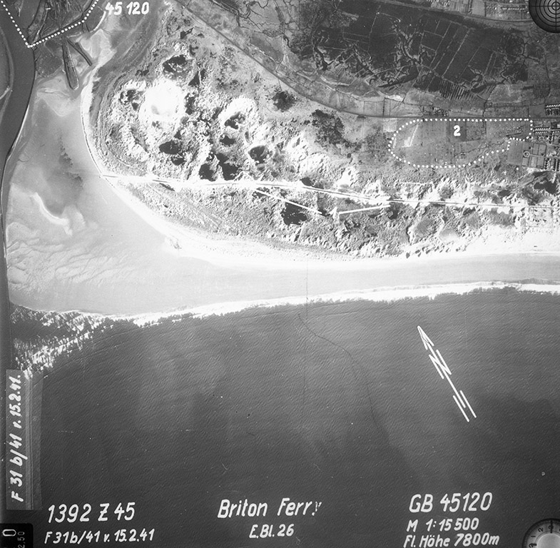
Below: The river mouth of the Afon Nedd and Briton Ferry in February 1941. The burrows had a road used since medieval times to allow travellers to cross the sands at low tides.
One of the reasons we know so little about the abundance or distribution of bats is the general technical difficulty of surveying and recording where they live and where they hunt. Nationally, the effort to monitor the bat population is significantly bolstered by the invaluable contribution of volunteers. Their dedication, although often underappreciated, plays a crucial role in our understanding of bat populations. However, this reliance on volunteer work, while commendable, is not without its challenges. The situation is further complicated by the need for specialized equipment and training. Although bat surveys have become a regular requirement for planning permission, the surveys remain expensive and knowledge is considered commercial and rarely shared, making understanding of bat distribution even more complex. Using specialist recording equipment means the data files for bat surveys can become very large very quickly, although the advantage is that the data is available for further analysis and verification.
I trained as a bat surveyor in the Thames Valley, where University researchers waxed lyrical about the high densities of bats along the river. One warm night we went out and didn’t detect a single one. That has never happened to me on Cilfái, where bat presence can be staggering on many nights.
Bat surveys have become high cost as surveyors seek to extract as much income from the work as possible. It is unfortunate, as much needed information then becomes restricted or unshared. That greedy attitude led me to share as much as I have on the bat presence on the hill in the second Cilfái book. Cilfái: Woodland Management and Climate Change on Kilvey Hill, Swansea.
On Cilfái, I use a combination of a handheld detector and automatic recorders, which give me a sample of several nights at various locations. This lets me hear the bat calls as they hunt and analyse the recordings at home. I use the classic handbook for techniques Jon Russ wrote (Russ 2012). I use Anabat Express (or equivalent) passive bat recorders and process the data with Anabat Insight Version 2. Over time, this gives me an understanding of the ‘hotspots’ of activity across the hill. I only get snapshots of what is happening, and I cannot realistically project what I know into the overall picture of bats on the hill. That will take a few years. I can assume that our ‘Year Zero’ in 1970 had no bat presence and that everything I see and hear in 2023 is the product of fifty years of recovery. However, realistically, the woodland only began its recovery in the mid-1990s.
The hotspots on the hill are where the food is. Generally, these are the open spaces where previous burning or wind damage has opened up the forest canopy and allowed a wider range of native plants to prosper. Some of these open spots are also good for birdlife. On a warm autumn evening, the air in the hotspots is thick, and flying insects attract the bats. I have evidence of a large presence of Common Pipistrelle (Pipistrellus pipistrellus) and Noctule (Nyctalus noctula). It is possible that hidden in my recordings is some evidence of the Brown long-eared bat (Plecotus auritus), only further data collection will confirm.
Although I can track and monitor activity, it remains immensely difficult to understand hibernation and roosting sites. I am slowly building up a library of bat presence data across the hill.
Russ, John. 2012. British Bat Calls: A Guide to Species Identification (Exeter: Pelagic).
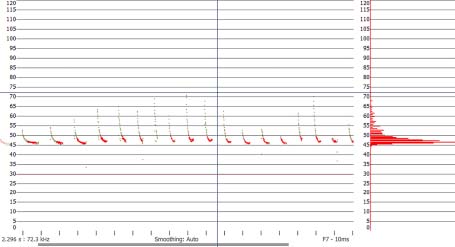
Below: Although it looks a bit technical, it is the nature of bat survey work that we prepare this kind of evidence. The land above Foxhole and the Glade is very busy with bats and clearance of trees will definitely cause problems for the population that has re-established up there. On the night this recording was made I had hundreds of similar records. You can see more evidence in the Cilfái book.
This is a recording of a Common pippistrelle hunting on the woodland edge above Foxhole in September 2023. Temperature above 20 Celsius (Analook F7) compressed with split-screen option Cycles, showing the characteristic call shape of a hunting pippistrelle.
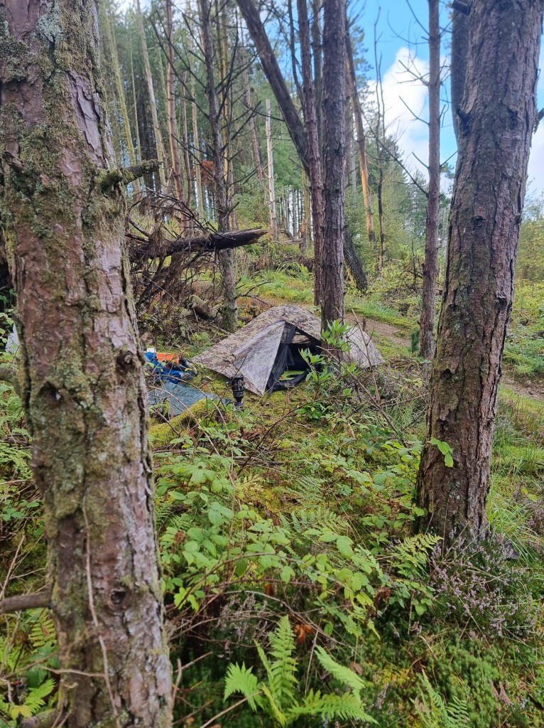
Below: Me bat surveying on the threatened land above Foxhole September 2023
We don’t have any ancient woodland on Cilfái. The last of it was killed off in the 1750s by industrial pollution. The coal industry on the hill probably removed most of the bigger trees before that as coal mining consumed massive quantities of timber. Both Cilfái and Townhill were cleared of their natural woodland by the 1300s (Robins 1990: 4–8).
1970 marked the new beginning of woodland on the Cilfái woodland site. We know that the Scots and Monterey pines on the western side were planted alongside efforts by the Forestry Commission to reestablish forestry on the upper slopes of the west side (Robins 2023a: 62–77, 2023b: 55–58).
Although the landscape of ancient woodland has disappeared, Swansea does have some incredible surviving old trees in Singleton Park and Penllergaer (Penllergare) Country Park. The trees in Singleton survived being part of farmland in the 1600s and were incorporated into the estate of the Vivian family in the 1800s (Morris 1995: 5–26).
The Penllergaer Country Park has some incredible survivors who survived the devastation of the coal mining period between 1500 and 1790 and became incorporated into the private parklands of the Dillwyn Llewelyn family. I wrote about some of the trees in Swansea History Journal a while back (Robins 2021).
The trees of Cilfái are special because we know how old they are and what they have gone through to survive today. The trees of Nyddfwch are special because they are far older but have also survived the ravages of industrialisation and human interference.
Morris, Bernard. 1995. The Houses of Singleton: A Swansea Landscape and Its History (Swansea: West Glamorgan Archive Service)
Robins, Nigel A. 1990. The Enclosure of Townhill: An Illustrated Guide (Swansea: City of Swansea)
These days we are often in a situation where we are forced to rely on the opinions of staff in various organisations to tell us what ‘history’ or ‘ecology’ or ‘biodiversity’ are. In and around Swansea, we have Cadw to judge what is ‘significant’ for heritage, an Archaeological Trust to tell us what is important under the ground, and a host of private companies employed by building developers to tell us what plants and animals are important. Unfortunately all these organisations can be flawed when it comes to understanding what matters to local communities. It is a deeply unsatisfactory situation. You’d expect local politicians to be more in tune with their communities, after all they were elected to do just that. However, the strong whipping of Swansea Labour Councillors over the Cilfái developments shows how impotent local politics actually is in the face of corporate ambitions.
The identification of heritage and cultural features on Cilfái is clearly inconvenient to politicians and tourism developers. The neat packages of the Hafod-Morfa tourist attraction are predictable, grant-friendly, and a big hit with local builders. Not so much the ‘informal’ heritage of Cilfái. The hill is packed with history above and below ground but that won’t matter to Councillors. Features with the unfortunate characteristic of ‘being in the way’ will be dug up, destroyed or removed. It is ironic that a tourism firm from New Zealand (a country that is barely 100 years old) is leading the destruction of our heritage, much older than that little country.
What tends to get lost first are the little things, the things that people enjoy. They often get thrown away because we as residents are told they aren’t significant by the organisations that ironically are there to serve us.
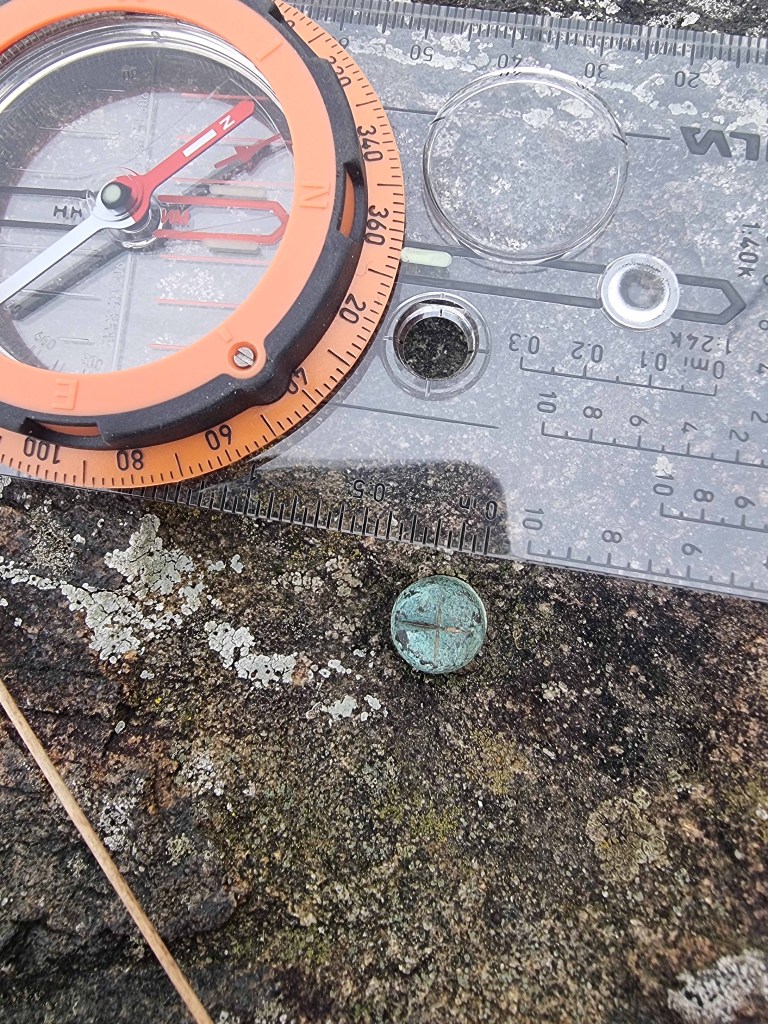
Here’s one that will probably be brushed away by a careless Skyline bulldozer. A little copper nail hammered into a rock in the danger zone. It was probably put there by William Logan as part of the early exploration of coal seams on the hill in the 1820s. I found his notebooks that told me about it. It remains as a little memorial to all the hard work and industry from pioneers in the past. The story is covered in Cilfái: History and Geography and Cilfái: Heritage Features
The waste tips and pollution on the hill are the obvious legacy remains of the copper industry. However, there are several other copper-related features on the hill. In Cilfái: The History and Heritage Features, I listed 16 features of Swansea copper heritage. One of them appears to have been completely missed by the several archaeologists that apparently surveyed the area. The Copper 14 Feature (listed on page 57) White Rock Hammer Pond Tunnel is an incredible survivor of a water course that supplied water to the water wheels of the original watermill that was on the White Rock site before the building of the works in 1737. It still works today carrying the Nant Llwynheiernin under the Pentrechwyth Road and into the White Rock site before running out to the river south of White Rock near the original White Rock coal yard.
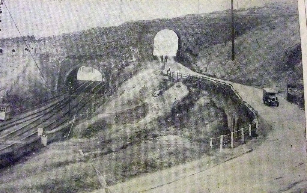
Below: The White Rock incline and site of Nant Llwyheiernin bridge and tunnel in the early 1930s. The bridge and tunnel still survive buried in the new road.
One of the big threats to a recovering woodland is habitat fragmentation. This is a huge problem for wildlife in Wales. I covered this in the second Cilfái book (Cilfái: Woodland Management and Climate Change on Kilvey Hill, Swansea). It is reasonable to assume that a big woodland is better for biodiversity and the environment than a small one. After two thousand years of habitat destruction in Wales we are left with one of the poorest environments in Europe. The woodlands we have are constantly being threatened with further subdivision as roads and houses are built in ever remote or pictureesque areas.
The woodland that has recovered since 1970 will now be fragmented further by the foreign tourism development which will cut through the centre of the biodiversity area. The impact on the recovering wildlife will be immense. The impact will be change and a reduction in opportunities for wildlife and plants on the vital central area of the hill. Fewer opportunities to live will result in fewer species and reduced biodiversity. That is habitat fragmentation.
In numbers, the 102 hectares of woodland and open access space we now have on Cilfái will be reduced to about 29 hectares of woodland. As a comparison, the country park of Penllergare (near Junction 47 on the M4), has about 67 hectares of mixed woodland and Singleton Park has about 11 hectares of (badly fragmented) woodland. So, yes, the loss of Cilfái woodlands is significant.
It may not necessarily be all doom and gloom. Swansea Council and the tourism developers will hopefully be obliged to produce a series of habitat recovery and restoration plans for various tracts of land that may be leased to the Company but will not be built upon. I assume pressure will be put on Welsh Government to provide a large sum of money for ‘native’ woodland restoration. As everybody who has a say is committed to cable cars and adventure tourism, I’m sure the money will come…it has to.
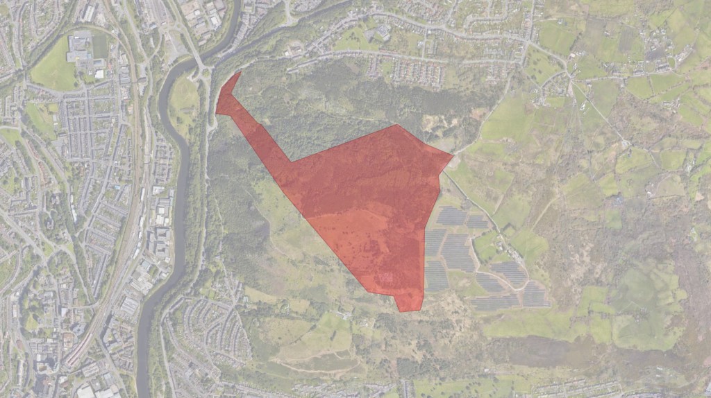
Below: The area of concern on Cilfái is coloured red here. A large chunk of this is the original Forestry Commission land (now NRW). A mixture of coniferous forest, fire damage and fantastic natural regeneration. Full of bats and birds. The contract ecologists bought in by the tourism firm will seek to devalue the quality of the environment and frame it as a place that is worthless and ripe for redevelopment.
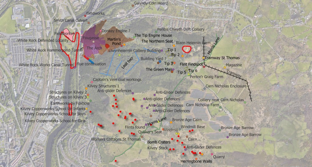
What was on the Archwilio site wasn’t really good enough for us to understand Cilfái, so I redid the surveys. I increased the heritage fetures count on the Hill from 35 to nearer 80. A lot of our Copper, Coal and modern history is not officially recognised by archaeologists…but it doesn’t make it unimportant. You can’t expect historians or achaeologists from elsewhere in England or Wales to understand the significance of our local history and culture. We are forced to do that for ourselves.
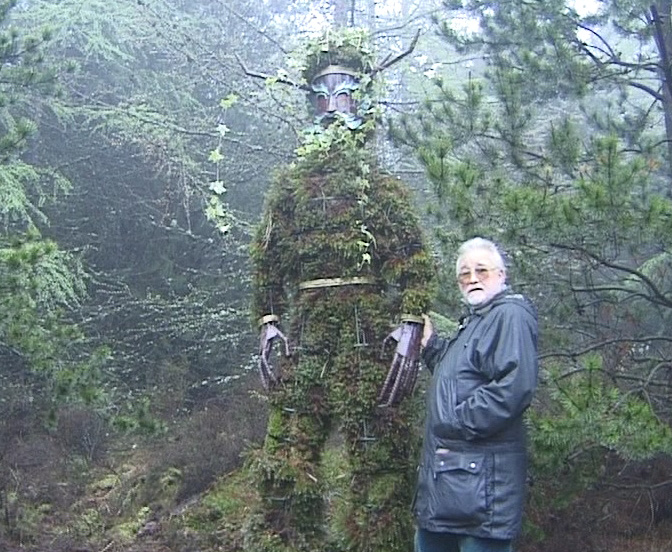
Below: Pete Thomas and Green Man in 1998 shortly after it was completed.
.
Below: A map of some of the heritage features on Cilfái.
When I worked for the Government, I did some tours of duty in environmental activities. Over the years, I monitored programmes on the health of Honeybees, parks protection in Greenwich’s ancient woodlands, Restoration of the environment in the Olympic site in East London, and several small conservation programmes on security sites for the MOD, where fencing things off from the general public did wonders for the local biodiversity.
In all of that, I learned that data and information are vital. Far too often I heard the comment ‘there’s nothing there!’, often from gentlemen in their fifties whose only interest in nature was how to kill it or cut it down. When I got to a position of some influence, I could slow down or even reverse developments by insisting on a good quality ecological survey before any construction work. Sometimes, this was deeply unpopular as the construction industry usually has little interest in conservation or environmental care…what we see of due diligence by building firms is there because the Law forces them. This will definitely be an issue in Cilfái with the Skyline development. That tourist firm will promise anything in the planning permission stage but quietly ignore it in the building phase, knowing very well that Swansea Council does not have the resources to monitor and enforce anything. We as volunteers will need to monitor the destruction to try and ensure it is kept to the promised minimum.
In December 2022, I prepared the first of a series of ecological protection documents based on my time in Whitehall. The key one is called an Ecological Constraints and Opportunities Plan (ECOP for short). I did one for Cilfái based on what we knew at the time. It proved quite popular and still is, judging from the large number of downloads it still gets from all over the country. Eventually, the ECOP evolved into the second book Cilfái: Woodland Management and Climate Change on Kilvey Hill, Swansea.
I published all my survey notes and plans going back over about ten years of tree and animal survey, including all my work on the Hill. So, the book has an explanation of the data covering the Hill and lists of bats, birds, plants and animals I found or saw presence of. I also included the wonderful observations made by Carl Squires over many years of walking the Hill. I also added some of my Climate Change risk analysis from my time working for UK Parliament.
Below: A mash-up of some of the Cilfái data from my surveys and explorations. It is complex because ecology always is. The red dots are dead or dying trees, the dotted lines and light green stripes are areas for better bird habitat, Yellows and oranges are different types of open land, and darker greens are the Forestry Commission plantation trees. The red lines show the ghost of the coming area of Skyline destruction.
When investigating the history of a landscape, one of the first things worth looking at is the underlying rocks that make up the land. In Wales, this is often the question, ‘Is there coal here?’ In Swansea, the answer is usually ‘yes!’
We can usually get a map showing us the geology of the land. In Swansea, we have the famous Sheet 247 to guide us. As a young student of Geology, my old Dynevor Geology teacher John Rees always told me to ‘get the Memoir’. It was sage advice, and referring to the Memoir is one of the most essential tools in a researcher’s toolkit. Even today, when I read my copy of the Memoir, it comes out in John Rees’ voice and tone in my head—the legacy of an excellent teacher.
The Memoir is the written guide that accompanies every British Geology map. Most were published in the nineteenth or early twentieth century. Whereas the map represents what is under the ground, the Memoir describes in detail all the features and rock types. Swansea’s Memoir was published in 1907 and is a priceless record of years of fieldwork and investigation by a team of accomplished geologists working throughout the 1890s (Strahan 1907). The original work of the Memoir began in the 1830s on Cilfái when pioneer Geologist William Logan taught himself geology by exploring the mines of Cilfái Hill.
The Memoir is a historical record in itself now, as almost all the landscape described has disappeared under housing and tarmac. The Memoir is vital to understanding the geology of Cilfái, and I refer to it many times in Chapter Two of Cilfái: Historical Geography.
Strahan, Aubrey. 1907. The Geology of the South Wales Coal-Field. Part VIII, The Country around Swansea: Being an Account of the Region Comprised in Sheet 247 of the Map, Memoirs of the Geological Survey. England and Wales, 247 (London: Printed for His Majesty’s Stationery Office by Wyman and Sons)
Below: The title page of the Swansea Memoir and below that Swansea as shown on the modern edition of Sheet 247. It still credits the original work by William Logan from the 1830s.
Yesterday (18 April 2024), Swansea Council took a first public step towards leasing or selling a large part of Kilvey Hill to a foreign tourist company. The decision was a milestone in a process started in secret in 2017. The years since have seen covert land assembly, including a particularly unpleasant land steal by Swansea Council, as politicians and staff work officially or otherwise to facilitate the plans of the foreign tourist company.
Our abysmal local government system’s callous, unthinking bureaucratic jargon describes the potential sell-off as a ‘disposal,’ as if the land were used tissue. This had happened before when previous generations and local councils enthusiastically embraced industrial development and regarded the destruction of nineteenth-century Kilvey as merely ‘collateral damage’ … a disposal problem.
The transformation of Swansea from an attractive resort to an industrial black spot was beautifully catalogued in a 1986 book called ‘The Brighton of Wales’ (Boorman 1986). Boorman traces the point of departure from unspoiled beaches to the Lower Swansea Valley industrial magnet. Now, the wheel has turned full circle as a desperate local authority, in acts of unbridled boosterism, refers to Swansea as a world-class tourism destination. I can only assume Councillors haven’t recently made that dangerous walk from Swansea railway station down the High Street.
There will be plenty of economic arguments for the developments to go ahead based largely on optimism and faith in the future. One thing is certain: the enthusiasts for the scheme and all the positive comments on those strange news sites don’t live there.
The Council and the local communities have a lot to be proud of regarding environmental recovery and the new uses of the urban woodlands on the east side. I wish the politicians would recognise this instead of chasing a handful of ice cream-selling jobs.
Boorman, David. 1986. The Brighton of Wales: Swansea as a Fashionable Seaside Resort, c.1780-1830 (Swansea: Swansea Little Theatre Company)
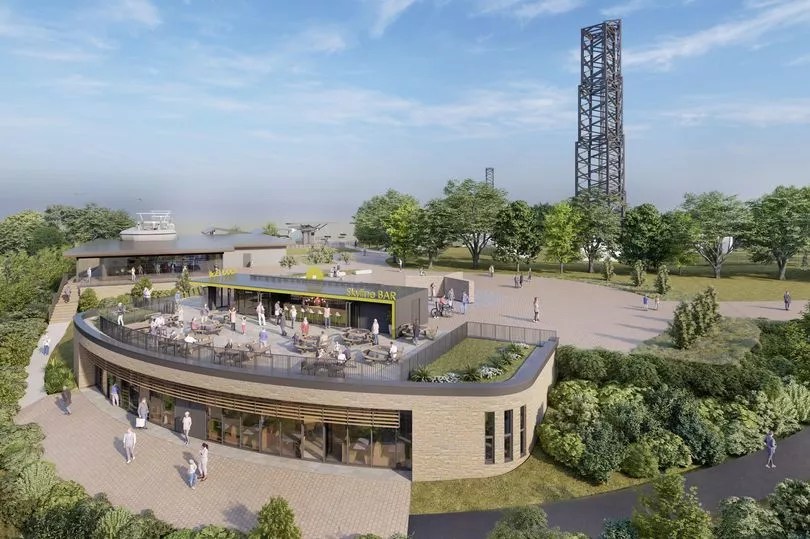
Below: The planned Skyline buildings. Incredibly, this picture is of part of Kilvey Hill that Swansea Council don’t actually own.