The Kilvey bombed landscape is unique in Wales, although bombs were dropped across the Welsh ports between 1940 and 1943, ther survival of any traces is rare. Several shrapnel-scarred buildings remain in Swansea, and a similar situation exists in other European towns and cities. What is unique in Wales is the survival of a landscape with craters that has been allowed to recover or develop naturally.
A look at the biodiversity contribution of the World War Two bomb craters on Cilfái.
I’ll be leading a couple of walks up the top of the hill soon. This year, I’m intent on looking at biodiversity and heritage. The bomb-damaged landscape of Kilvey Hill is now 84 years old, and a lot of it has survived or avoided being bulldozed, as often happens. Ironically, the heritage landscape of the Hill may soon be destroyed by Swansea Council as part of their Skyline tourism obsession.
The Kilvey bombed landscape is unique in Wales, although bombs were dropped across the Welsh ports between 1940 and 1943, the survival of any traces is rare. Several shrapnel-scarred buildings remain in Swansea, and a similar situation exists in other European towns and cities. What is unique in Wales is the survival of a landscape with craters that has been allowed to recover or develop naturally.
Many of you will know of my interest in bombsite botany via my lectures and articles, and one of the chapters in my book on the Three-Nights’ Blitz. Although formed in horrible acts of violence, the Kilvey bomb craters have been transformed by nature into essential wildlife refugia. Some hold small ponds, others are havens of warmer temperatures and protection from the wind, or even fire. The combustion of chemical explosives would have made the craters poisonous after their creation, and of course, the land is peppered with bomb fragments, which have become part of the archaeology of the hill. Nearly a century later, the craters have taken on a new role as centres of plant and wildlife.
I’ll explore this incredible mix of heritage and ecology on a couple of walks. I’ll advertise via Eventbrite, and I’ll let you know here as well.
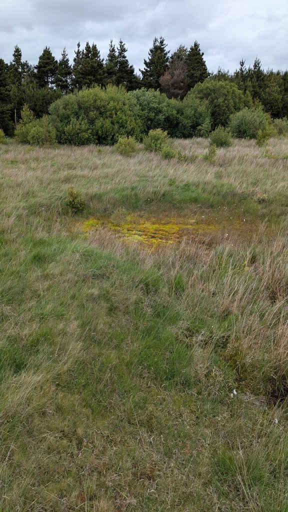
Above: One of the Kilvey bomb craters with a small mire. June 2025.
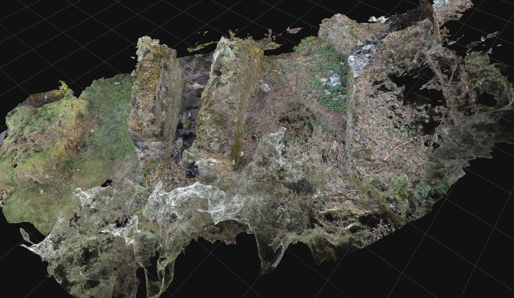
A photo-generated 3D model of one of the Kilvey bomb craters, March 2025.
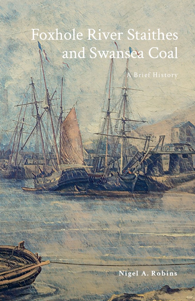
The Foxhole River Staithes are a set of enigmatic structures on the banks of the River Tawe near the remains of the White Rick Copper Works. Although now hidden by trees and slowly deteriorating, they were once the centre of the incredible coal industry that dominated Kilvey and Foxhole in Swansea. This book describes the history of coal in early Swansea and explains the significance of the last remaining structures of the coal industry of early Swansea before the arrival of copper smelting in the 1730s
I completed my cheap photography project last month, and added it to my early Swansea coal history book.
The history of Swansea coal is being lost amongst all the noise and gravy train funding for the Hafod/Morfa Copperopolis story. My work on Swansea coal is meant to redress some of that imbalance and cast new light on a part of the Lower Swansea Valley that isn’t considered important.
The photogrammetry was a great success, completed for a few hundred pounds rather than the thousands claimed by local firms. The constraints were to use second-hand cameras and computers, and to provide imagery of a quality and level of detail that would prove useful. No drones were used as we found that they were adding a layer of costs and complexity that was distorting the value of what should be an extremely cheap and quick process.
After discussing the protocols with a couple of BIM colleagues, I looked at the protocols described in this 2011 paper (listed below). Despite being a little older than the average BIM work these days, the workflows were good, easily replicated, and I could learn how to use simpler, older cameras for the imagery.
There was a series of trials of various landscape and heritage features, ranging from riverside bollards, dock walls, and larger landscape features such as bomb craters and threatened landscapes. The larger subjects needed drone input, and so they were discarded, although some beneficial results were obtained for researching biodiversity and small-scale features which I’ll follow up in a later project.
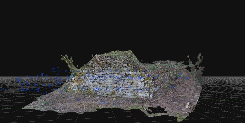
The study subjects were the Foxhole River Staithes, which were of good size (typically about 8m wide, 3m high) and interesting construction. The photographic survey took just over three days, with about four thousand images collected. Office processing of the imagery took about three days.
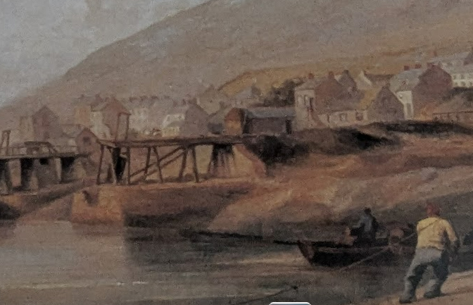
Above: An ‘aerial’ view of one of the Staithe Structures reconstituted from ground photogrammetry, no drones, merely ground camera work.Above: Another view of Foxhole Structure B. A series of stone retaining walls that originally had timber decking, allowing the loading of coal into various-sized river vessels. Built in the early eighteenth century, probably before extensive copper smelting had begun.Above: Some of the mines and coal veins of early Swansea, discussed in the book.
The photogrammetry was included in a book giving a brief history of coal in Swansea and the significance of the Foxhole area in pre-industrial Swansea.
Fai, Stephen & Graham, Katie & Duckworth, Todd & Wood, Nevil & Attar, Ramtin. (2011). Building Information Modeling and Heritage Documentation.
“The Foxhole River Staithes are a set of enigmatic structures on the banks of the River Tawe near the remains of the White Rick Copper Works. Although now hidden by trees and slowly deteriorating, they were once the centre of the incredible coal industry that dominated Kilvey and Foxhole in Swansea. This book describes the history of coal in early Swansea and explains the significance of the last remaining structures of the coal industry of early Swansea before the arrival of copper smelting in the 1730s. The story of the coal mines of Swansea, the coal export trade and the ships that visited eighteenth-century Swansea are all described. The book also includes the results of photogrammetric surveys of the surviving structures to give the story of the true significance of the Foxhole Staithes and their place in Welsh history.”
The work here was added to original surveys carried out in the 1980s, and a comparison with photographic records allowed a visual check of the structure’s deterioration and environmental changes. A review of the geology of the structure’s building materials could also be carried out, which revealed distinctive contrasts between this structure and other post-1737 structures and walls nearby.
I’m really pleased that this small project is now starting to yield results! The first delivery was a series of scans and interpretations of some rare dock structures on the banks of the River Tawe. Some of the structures are scheduled ancient monuments, but the oldest and rarest are not!
The brief for this structure was a cheap and accurate photogrammetric survey at the lowest cost, allowing for interpretation and enhancing the historical information from earlier work and new research. The requirement was cheap, quick and accurate, which meant no expensive drone or landscape surveys.
Above: An early eighteenth-century coal staith remains in the Swansea Valley.
The work here was added to original surveys carried out in the 1980s, and a comparison with photographic records allowed a visual check of the structure’s deterioration and environmental changes. A review of the geology of the structure’s building materials could also be carried out, which revealed distinctive contrasts between this structure and other post-1737 structures and walls nearby.
There is still much to do, including costing the project and leveraging the technology more effectively on little-known structures in the area.
The concept of quick and cheap photogrammetry is now proven, and simple work like this can be comparable to expensive archaeological surveys, which cost far more, often a hundred times more than current archaeological firms charge.
As I said earlier, the purpose of this project was a proof of concept on using photogrammetry as cheaply as possible to allow quick and accurate reconnaissance and survey of small features that generally would not be investigated or be too expensive to survey using current high-cost photogrammetry, drone and lidar techniques.
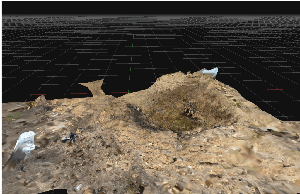
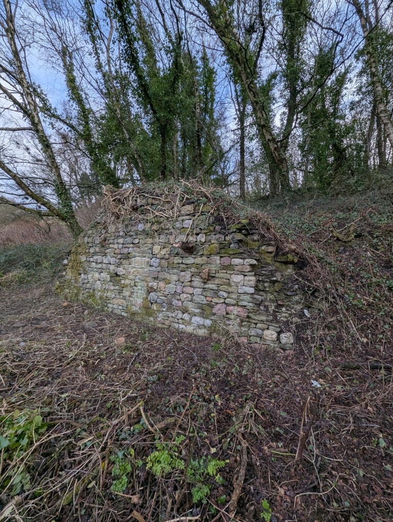
This example is a bomb crater on Kilvey Hill. The crater was most likely created in the January 1941 attack on the town. The crater is from a large calibre bomb (possibly 250kg) that has penetrated some way into the soft, marshy ground and then detonated.
In the 84 years since the detonation, the crater has softened with the crater lip mostly eroded. The crater frequently fills with water and has a different botanical nature to the surrounding grassland. This crater is a local biodiversity hotspot, allowing moisture to be present all year round and providing better protection from excessive temperatures. A large pine in the centre of the crater has died providing a reservoir of dead wood.
Above an extract from an initial 3D model of one of the Kilvey bomb craters, 2025.
The concept of quick and cheap photogrammetry is now proven, and simple work like this can be comparable to expensive archaeological surveys, which cost far more, often a hundred times more than current archaeological firms charge.
I’ve got some funding to run a small Heritage BIM project. I’m running a photogrammetry project on a few small and less well-known industrial remains in the Swansea Valley. The proposal is to explore how effective and cost-effective cheap photogrammetry can be in surveying and analysing small structures and supplement statements of significance. With reference to CIDOC and ISO 19650.
I’ve got some funding to run a small Heritage BIM project. I’m running a photogrammetry project on a few small and less well-known industrial remains in the Swansea Valley. The proposal is to explore how effective and economical cheap photogrammetry can be in surveying and analysing small structures and supplement statements of significance. With reference to CIDOC and ISO 19650.
I worked on several Heritage BIM projects whilst an analyst on the Restoration and Repair of the Palace of Westminster. The technologies are evolving fast, and the extortionate costs of older photogrammetry are now being superseded by new technologies and approaches. I remember the original photogrammetry of the Palace was eye-wateringly costly, but once captured, hardly anyone knew how to effectively leverage the data into applied and valuable information. The result was old data that quickly went out of date and used before it could benefit the programme.
This will be an opportunity to explore revised workflows, effective use of low-cost technology, and output into usable heritage information for a few neglected monuments. It also provides an opportunity to revise old and outdated information, review the significance of the monuments in light of more recent viewpoints on heritage and interpretation, and maybe look at ontology and some standardisation and interoperability issues in HBIM. All with a view to convert data into valuable knowledge effectively and for a reasonable cost.
I’m looking forward to getting back into HBIM and a heritage project!
Above: A prime candidate: a significant structure from eighteenth-century coal mining history. It is mainly unprotected and needs modern interpretation.
Now working on the final shortlist of appropriate monuments and structures for the project. Down to a shortlist of three. The final selection will depend on the extent of the current knowledge and interpretation of the selected structure. A poorly documented structure will score higher.
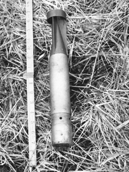
The incendiary bomb used to attack Swansea was known as the ‘Elektron’. a slim tube of aluminium and magnesium with an incendiary filling. The little bomb had a hard nose designed to penetrate a slate roof and settle in the attic, where it would gradually start a fire. The Swansea Civil Defences and auxiliary firemen learned various ways to deal with the bomb, but it was civilians, including women and children, who tackled most of the burning bombs.
Incendiary bombs were heavily used by all World War Two air forces to attack civilians. Swansea was attacked on several occasions with large numbers of incendiary bombs, which eventually caused complete destruction of most of the town centre.
Incendiary bombs to specifically attack houses were a German invention from World War One. Still, it was in the middle years of the Second World War that they really became a favourite weapon of air forces.
The incendiary bomb used to attack Swansea was known as the ‘Elektron‘. a slim tube of aluminium and magnesium with an incendiary filling. The little bomb had a hard nose designed to penetrate a slate roof and settle in the attic, where it would gradually start a fire. The Swansea Civil Defences and auxiliary firemen learned various ways to deal with the bomb, but it was civilians, including women and children, who tackled most of the burning bombs.
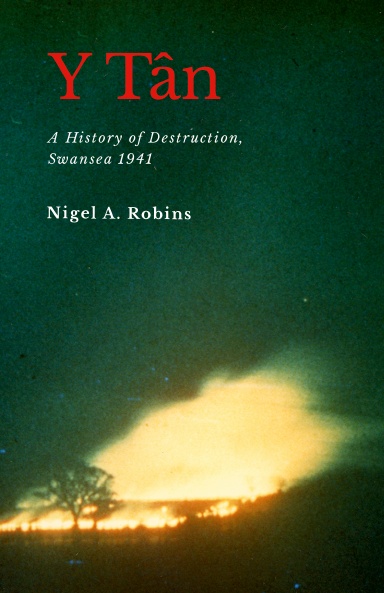
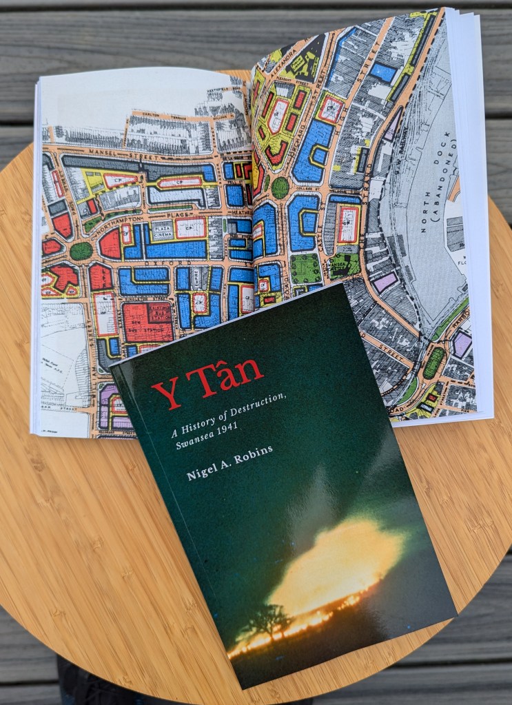
Below is a page from Y Tân: A History of Destruction, Swansea 1941, with pictures from a civil defence manual showing how to tackle a burning Elektron bomb. It was important for morale to show a woman dealing with the bomb and hundreds of bombs in Swansea were extinguished by women with sandbags and stirrup pumps.
The full story of Swansea dealing with incendiary bombs during the Three Nights’ Blitz is told in the book.
In Swansea, as the anniversary of the February 1941 bombing raids approaches, interest in the Blitz always increases.
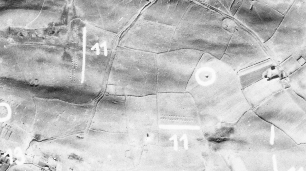
Kilvey Hill has many bomb craters across its southern part and into the woodlands near Pentrechwyth. Most craters date from September 1940 to February 1941. The German Air Force didn’t aim at Kilvey Hill; it’s just that the bombs that were intended for the docks missed and ended up on the hill. Bomb craters in town were quickly filled in, but craters on the hill were left and still survive today. A few have filled with water and have become biodiversity hotspots.
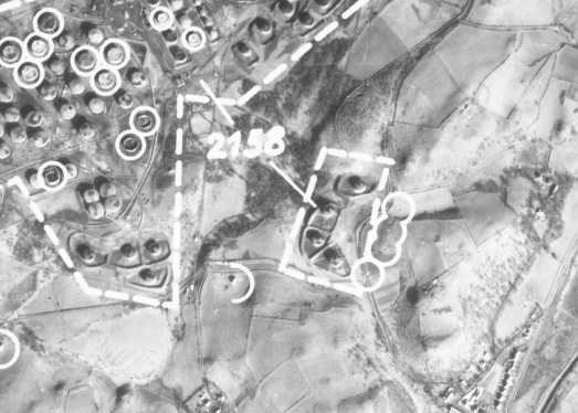
Above: bomb craters and anti-landing defences on the top of Kilvey Hill as identified by German bomber aircraft in February 1941. The anti-landing trenches are marked with ’11’ and a white line.
Kilvey also has a series of ditches and banks across the top, which were hastily constructed to prevent German soldiers from landing on the Hill in gliders. It was a definite threat, and my reconnaissance research confirms that the Germans had evaluated the usefulness of the Hill as a landing ground if they ever invaded. They survive as a poignant reminder of how real the threat was in 1940. The Council/Skyline development will destroy some of the banks, breaking a remarkable historical link between the darkest days of World War Two and our present day. It is ironic how so much is made of the disappeared Swansea copper industry in Landore is revered, but so much more recent and relevant history is ignored by Swansea Council.
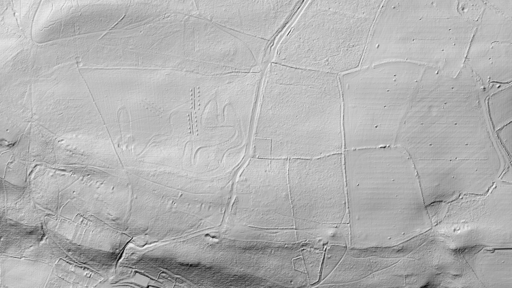
Above: A modern Lidar image of the top of Kilvey Hill showing the anti-landing trenches as they exist today as little square hillocks either side of deep trenches. They would have made landing by glider very dangerous or impossible. The flat part of the hill top was particularly attractive as a landing ground.. Morris Lane runs from the top to the bottom of the image and is seen as a series of earth banks.
Above: The top of Kilvey Hill today. Bomb craters in red, Glider defences in Red.
If you want to know more about all of the archaeological features on Kilvey Hill, they are listed and described in the third Cilfái book available here.
Cilfái: The History and Heritage Features is a 100-page illustrated book of all the historic features on the hill.
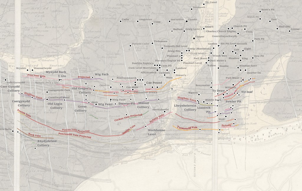
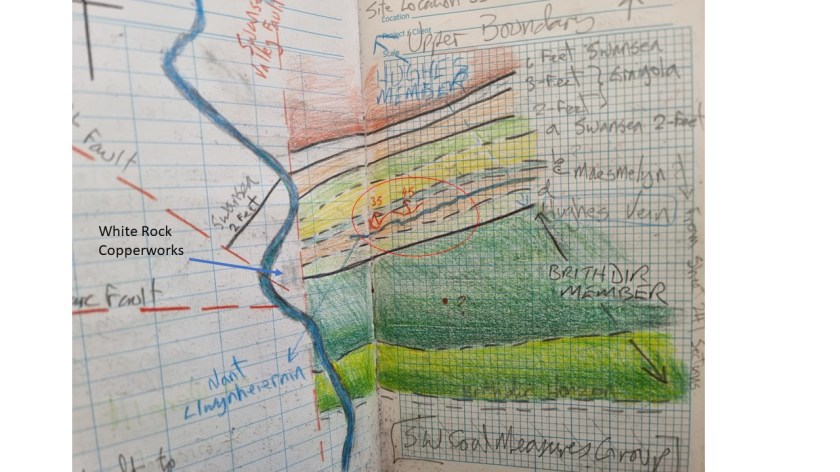
Henry De la Beche and William Logan, between 1836 and 1841, conducted considerable research on the hills of Town Hill and Kilvey (Cilfái) in Swansea. Understanding the dip of the sandstone beds and the coal veins that ran through the rock helped both men understand the relationship between the Pennant Sandstone and the coal seams that Swansea was built upon. Kilvey has a coal mining history extending back at least a thousand years.
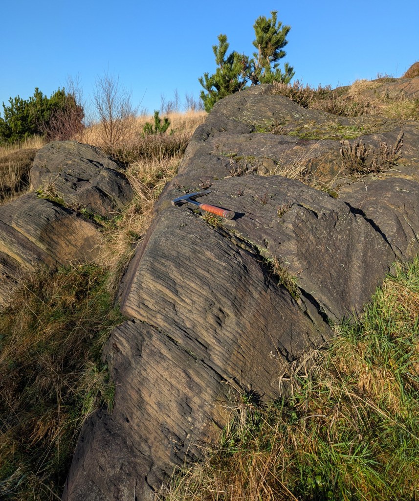
Above: A rock exposure on the southern slope of Kilvey last week. I took some record shots of the geology because this lies within the Swansea Council Skyline threatened area and it may be destroyed.
This exposure of weathered sandstone would have been examined by William Logan and both men would undoubtedly have discussed it as they worked to understand the more complex geology of Town Hill and northern Swansea. You can see the rock here dips down. In fact, it dips at about forty degrees to the north, which means that coal seams exposed on the surface on Kilvey would be hundreds of metres underground by the time you reached Morriston. Beche and Logan were trying to understand how and where to find those deep coal veins to allow better locations for new coal mines.
The layers of sandstone and siltstone are very thin here, and centuries of atmospheric pollution have highlighted the separate layers. Other parts of Kilvey have thick beds of stone used to build the Prince of Wales Dock and the Port Tennant houses.
Above is my sketch map of Kilvey showing the sandstone and coal veins as De la Bech and Logan would have seen them. The rocks in the picture above are part of the ‘Brithdir Beds’.
My next book is about the work of these two men and how they worked to understand the veins of coal that were so important to Swansea in the nineteenth century.
This has now been reissued as a 2025 Second Edition. I’ve also updated the copyright and EU product compliance details.
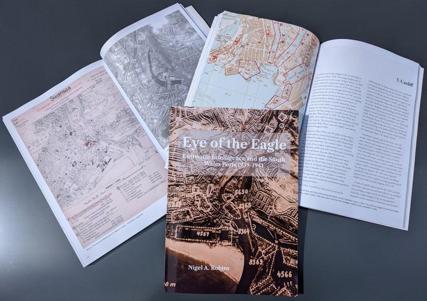
The first version of Eye of the Eagle was published in 1993. At that time, the research was to look at local landscape history, and British government aerial photographs were prohibitively expensive for such research, whereas, with a bit of effort, the Luftwaffe aerial surveys were freely available albeit via the record offices of the USA. As a geographer, my first instinct was to look for photographs and maps that give a first impression of a landscape before experiencing the land by walking. Since those days, a revolution in information sciences has changed so much. British record offices are far easier to engage with, and online and digital sources provide a wealth of resources and historical riches that were undreamed of in the 1990s. Combining the images with appropriate GIS/GPS systems has provided spectacular insights into ancient woodland and post-industrial recovery of land.
However, what has not changed is the research and writing techniques that underpin our discipline. This book has been written several times, only to be rewritten when new sources become available or are revealed in the improved access or digitisation of various records. Some of the many images and sources you will see here were rescued from rubbish dumps as organisations sought to ‘become digital’ in the early 2000s by throwing away ‘old’ records. Which explains their rather ‘worn’ looks.
Llandarcy showing destroyed oil tanks and near misses after the 1940 bombing raids.
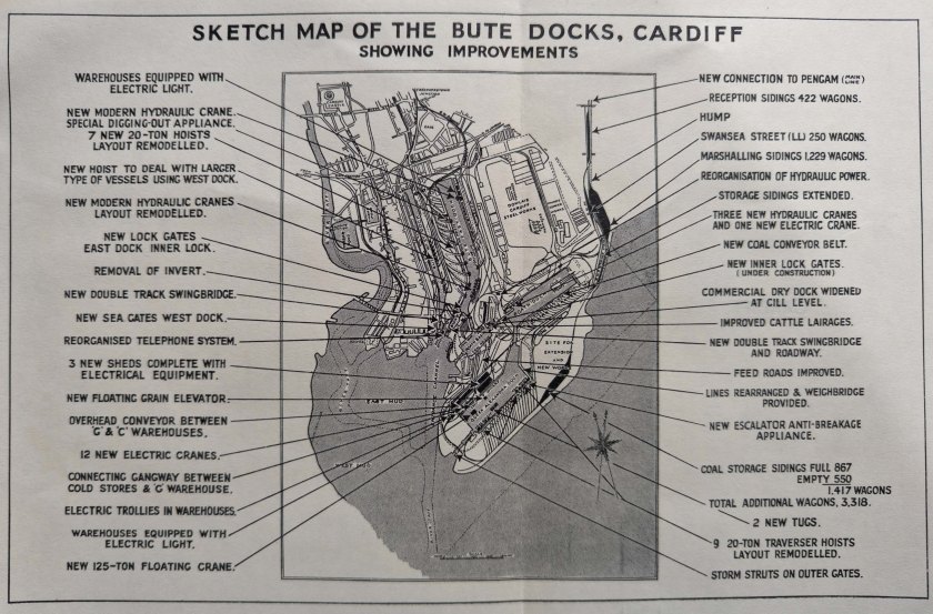
One of the GWR plans of Cardiff used by thew Luftwaffe to plan their air attacks in September 1939.