Heritage Data Requirements

Nigel A Robins (2022) Heritage digital asset management data requirements. Zenodo. doi:10.5281/zenodo.6912783. https://zenodo.org/records/6912783

This is my work list for the Heritage Data Requirements Strategy for the Palace of Westminster Restoration and Repair. This is an outline of the work, most of which was completed. This evolved into a fairly detailed Heritage AIM, although the final execution of any plan was never completed.

This script provided the basis for several other projects that were perhaps more successful, or at least easier to work alongside.

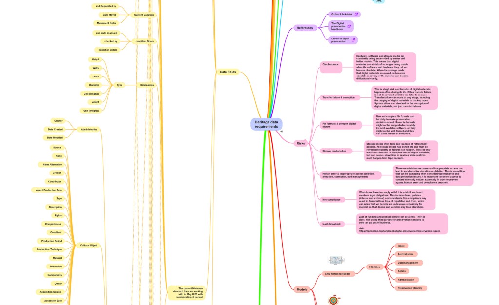
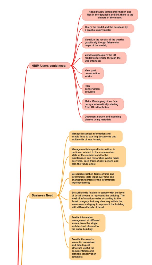
Analysing the ‘as-is’ situation, via intensive and sometimes exacting canvassing and fieldwork, highlighted many problems with current cataloguing standards and the extent of deployment of systems and staff capabilities (the current minimum inventory standard of core information for Axiell Emu). All very difficult challenges. The original data fields (Data fields on the card box system) were too focused on legacy data and staff skills from earlier decades. The recognition of what HBIM users could need (HBIM Users could need, Business Need) was difficult for conservation staff who were worried about job security.

After the BA fieldwork, some alternative schemes were mooted (New Scheme?). A certain amount of tension emerged between current users of Spectrum 5.0 and the IT managers (who knew very little about Heritage CMS). A decomposition of Spectrum 5.0 was essential to highlight exactly where issues with data security and staff attitudes were likely to clash. At this point, I thought it advisable to introduce BIM elements (Semantic Information Levels). This was an attempt to establish consensus on what was needed. IT staff were poorly grounded in the realities of building conservation and found it challenging to understand concepts such as Levels of Detail, including discussions of scale.

Above: Extract of Heritage Data Needs. Click for full document.

Continued canvassing and fieldwork led to identification of a pick list of data fields (Data Fields). Decomposition of data fields resulted in a scratch list of risks (Risks) which proved pleasingly accurate when I was able to discuss with other institutions and organisations.

Above: The initial risks which were subsequently enlarged into a risk register. Click for the full document.

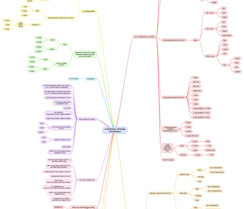
Metadata proved a challenge as agreeing a helpful starter list was remarkably difficult. Again, much of this was due to a lack of experience amongst IT staff who remained blissfully unaware of FISH (https://heritage-standards.org.uk/) or Getty AAT.

Finally, Use Cases were completed (Potential Use Cases). The initial work was via a set of personas, again some of these concepts were novel to staff and great care had to be taken to introduce concepts gradually. The detailed use cases were assembled using conventional requirements gathering and design definition processes (via BABOK sec. 7 etc.).

Above: Extract from Heritage Data click for the full document.

John Hardman and Co., Birmingham metalworkers and problems of conservation

I needed to produce an ontology-based version of the ornamental metalwork output of John Hardman (https://www.gracesguide.co.uk/John_Hardman_and_Co). This originated from work in the various furniture collections of the Palace of Westminster. The Palace has large quantities of ornamental metalwork, particularly candle holders of various kinds, which were popular in the nineteenth century. Particular types of metalwork are frequently at greater risk. Whilst most can agree on the conservation case for a Hardman candle branch from the 1860s, fewer understand the extreme risk posed to classic door furniture from modern facilities management or unsympathetic cleaning regimes using abrasive chemicals. The catalogues used in the Palace were old, incomplete or had not been regularly updated or maintained through a series of digital systems. The risk to objects is large, as a comprehensive catalogue entry is often the first line of defence against damage or loss. This ontology was an attempt to communicate the scope of essential information that needed to be linked and understood for future systems.

I needed to produce an ontology-based version of the ornamental metalwork output of John Hardman (https://www.gracesguide.co.uk/John_Hardman_and_Co). This originated from work in the various furniture collections of the Palace of Westminster. The Palace has large quantities of ornamental metalwork, particularly candle holders of various kinds, which were popular in the nineteenth century. Particular types of metalwork are frequently at greater risk. Whilst most can agree on the conservation case for a Hardman candle branch from the 1860s, fewer understand the extreme risk posed to classic door furniture from modern facilities management or unsympathetic cleaning regimes using abrasive chemicals. The catalogues used in the Palace were old, incomplete or had not been regularly updated or maintained through a series of digital systems. The risk to objects is large, as a comprehensive catalogue entry is often the first line of defence against damage or loss. This ontology was an attempt to communicate the scope of essential information that needed to be linked and understood for future systems.

In the 1830s, a collaboration with Augustus Pugin considerably enhanced Hardman’s output, and the Palace of Westminster has many examples of the finest Hardman output at all scales and sizes. Although I do find Hardman metalwork and fire furniture in many other large buildings.

Above: Gouge marks from inappropriate screwdrivers on irreplaceable Hardman door plates. A good quality HBIM approach will save money, prevent damage, and preserve furniture by providing essential information and guidance to the correct level of detail for maintenance staff.

Some large public buildings will have complex collections of ornamental metalwork, and most of this is not recognised nor its significance recorded. Items at greatest risk include door furniture, which is often exposed to damage and loss by restorers and maintenance staff who remain unaware of the significance. A good example is the use of caustic cleaning chemicals on brass door furniture, resulting in the erosion and destruction of the original finish. Another common issue is the use of the wrong size screwdrivers, resulting in broken screws that were handmade in the nineteenth century and are now irreplaceable. There is also a need to recognise the wide scope of lighting products for candles and gas available to architects and designers in Victorian Britain, many of which were installed in significant public buildings.

Whilst many items are recognised within the Getty Art and Architecture Thesaurus AAT  (https://www.getty.edu/research/tools/vocabularies/aat/), there are several omissions, and I found that the  AAT is not representative of the wide range of British artistic output in the second half of the nineteenth century.

Above: When a lock plate is removed for whatever reason, the staff frequently break the screws, making it impossible to replace the door furniture and leaving the door looking like this in a significant public-facing corridor. A good-quality HBIM catalogue will reduce the likelihood of this kind of damage, by providing the essential care information at the point of need.

This approach involves relating actual examples of Hardman items in British buildings to the various catalogues released by the company.  Items were identified from various catalogues, museum listings, informal cleaning records, and property registers, and most were confirmed by fieldwork to confirm the physical presence (or, in some cases, survival) of the item.

Alongside the fieldwork in several house collections and the Palace of Westminster, I found the Hardman Collection at Birmingham Library of particular use, particularly the Metal Sales Ledgers and their delivery books.

Nigel A Robins. (2022). John Hardman (1880s) and Co. data and product ontology (Version 1). Zenodo. https://doi.org/10.5281/zenodo.6912960

Above an extract from my original Hardmans ontology. https://doi.org/10.5281/zenodo.6912960

Values, Significance, Attributes, and Authenticity: Leveraging the best of IUCN Guidance

I was particularly struck by a recent opinion piece in The Lancet Planet Health on the links between human health and wellbeing and diverse nature.2 It’s an approach that remains at the centre of my use of Kilvey/Cilfái as a landscape for teaching. Early on, I could see that an overemphasis on biodiversity to the exclusion of other aspects of the environment would inevitably lead to a partial appreciation of the landscape.

Subscribe to continue reading

Subscribe to get access to the rest of this post and other subscriber-only content.

Geodiversity and Geoheritage: Building a Case Study for Cilfái

In the autumn of 2022, the local Council announced their plans to remodel the ancient Kilvey Hill landscape for a new tourism development, which would destroy the traces of thousands of years of human habitation and endeavour. The impending destruction led me to do what I could to record the history, ecology, biodiversity and Geoheritage of what is a significantly under-recorded landscape with considerable potential for education, well-being and climate change management.

Documenting the history and biodiversity was relatively straightforward, albeit a challenge to perceptions regarding a large area of land that many people see but few have experienced and even fewer understand. I remember one comment from the local authority about ‘there is nothing up there’.  A comment I later understood as a self-serving phrase to make the destruction and loss more comfortable for planning permissions.

Above: The thinly bedded sandstones of sandstone on Kilvey are part of a broad range of types of structure on Kilvey, along with massive beds heavily used for building stone and the bituminous coal seams that were so important to early Medieval Swansea.

I suppose my perceptions were different, having had the advantage of a geological education at school and undergraduate level, including a hectic month of field mapping coastal regions of the Isle of Wight back in the day. I hadn’t appreciated how much of that had stuck with me until I needed to explore the Geodiversity of the Hill through documents, fieldwork and the wonderful archive of the British Geological Survey.

The fact that the natural heritage of any country includes its geological heritage is now slipping away from us. The wonderful naturalists’ clubs of the early twentieth century, such as the Swansea Scientific and Field Naturalists’ Society, were a broad church to all aspects of nature, including geology.  But they have disappeared in the swing towards wildlife rather than general nature conservation, which has permanently obfuscated much of our wonderful Welsh geological heritage. The process accelerated as Naturalists’ Societies changed their names to Wildlife Trusts.

The collapse of geology as a subject deemed worthy of learning and the dissolution of the geological part of the National Museum for Wales have meant that describing the significance of geological sites has become challenging, as basic literacy in the nature of rocks and the landscape is in freefall.

Geoheritage and Geodiversity featured strongly in my first book on the history of Cilfái, not least because it was good history as well as good geology (Robins 2023a). I sought to highlight the significance to local heritage of the geology by separating ecology, biodiversity and climate change into the second Cilfái book (Robins 2023b). However, I felt my treatment of Geoheritage in the first book was not enough. I included a more substantial piece on Swansea’s coal history in my book on the Swansea Foxhole Coal Staithes, but the rich history of William Logan, Hendry de La Beche and Aubrey Strahan clearly deserves more (Robins 2025).

‘Every outcrop has the potential to be great’ (Clary, Pyle, and Andrews 2024) was an opening line to a recent special publication from the Geological Society. It’s a great opening line, and it sets a very positive note for a lively discussion on Geoheritage on a landscape scale. It’s a sentiment that is less positively upheld in Wales where our process of listing or recording sites of geological interest is haphazard and starved of interest and funds.

Above: An extract from one of William Logan’s many notebooks from the 1830s. Logan made regular visits to the outcrops above White Rock as he sought to understand stratigraphy and dip of the beds for coal exploration.

Nevertheless, the listing of a Kilvey site visit on the coming UNESCO International Geodiversity Day is a good opportunity to explore and reassess local Geoheritage. In preparing information for the International Geodiversity Day, I was particularly struck by a recent article linking Geoheritage and Cultural Heritage (Pijet-Migón and Migón 2022). The authors have introduced a model of themes at the Geoheritage-Cultural Heritage ‘interface’. It’s a very useful summary of what to explore or be aware of when revisiting geological sites. It helps move forward from traditional geological guides and texts (Owen 1973), which, although very useful, need to be modernised and broader in scope and engagement for a new generation.

Although the Pijet-Migón model doesn’t fit everything, for example, it can be broadened to explore the link between Biodiversity and Geodiversity, it is very useful. Here’s the Cilfái Geoheritage Landscape filtered through an amended model:

Clary, Renee M., Eric J. Pyle, and William Andrews. 2024. ‘Encompassing Geoheritage’s Multiple Voices, Multiple Venues and Multi-Disciplinarity’, Geology’s Significant Sites and Their Contributions to Geoheritage, no. Special Publication 543, pp. 1–7, doi:10.1144/SP543-2024-34

Owen, T.R. 1973. Geology Explained in South Wales (David & Charles)

Pijet-Migón, Edyta, and Piotr Migón. 2022. ‘Geoheritage and Cultural Heritage – A Review of Recurrent and Interlinked Themes’, Geosciences, 12.98, doi:10.3390/geosciences12020098

Robins, Nigel A. 2023a. Cilfái: Historical Geography on Kilvey Hill, Swansea (Nyddfwch)

——. 2023b. Cilfái: Woodland Management and Climate Change on Kilvey Hill, Swansea (Nyddfwch)

——. 2025. Foxhole River Staithes and Swansea Coal (Nyddfwch)

Biodiversity and Bomb Craters

The Kilvey bombed landscape is unique in Wales, although bombs were dropped across the Welsh ports between 1940 and 1943, ther survival of any traces is rare. Several shrapnel-scarred buildings remain in Swansea, and a similar situation exists in other European towns and cities. What is unique in Wales is the survival of a landscape with craters that has been allowed to recover or develop naturally.

A look at the biodiversity contribution of the World War Two bomb craters on Cilfái.

I’ll be leading a couple of walks up the top of the hill soon. This year, I’m intent on looking at biodiversity and heritage. The bomb-damaged landscape of Kilvey Hill is now 84 years old, and a lot of it has survived or avoided being bulldozed, as often happens. Ironically, the heritage landscape of the Hill may soon be destroyed by Swansea Council as part of their Skyline tourism obsession.

The Kilvey bombed landscape is unique in Wales, although bombs were dropped across the Welsh ports between 1940 and 1943, the survival of any traces is rare. Several shrapnel-scarred buildings remain in Swansea, and a similar situation exists in other European towns and cities. What is unique in Wales is the survival of a landscape with craters that has been allowed to recover or develop naturally.

Many of you will know of my interest in bombsite botany via my lectures and articles, and one of the chapters in my book on the Three-Nights’ Blitz. Although formed in horrible acts of violence, the Kilvey bomb craters have been transformed by nature into essential wildlife refugia. Some hold small ponds, others are havens of warmer temperatures and protection from the wind, or even fire. The combustion of chemical explosives would have made the craters poisonous after their creation, and of course, the land is peppered with bomb fragments, which have become part of the archaeology of the hill. Nearly a century later, the craters have taken on a new role as centres of plant and wildlife.

I’ll explore this incredible mix of heritage and ecology on a couple of walks. I’ll advertise via Eventbrite, and I’ll let you know here as well.

Above: One of the Kilvey bomb craters with a small mire. June 2025.
A photo-generated 3D model of one of the Kilvey bomb craters, March 2025.

The Foxhole Coal Staithes, Swansea

The Foxhole River Staithes are a set of enigmatic structures on the banks of the River Tawe near the remains of the White Rick Copper Works. Although now hidden by trees and slowly deteriorating, they were once the centre of the incredible coal industry that dominated Kilvey and Foxhole in Swansea. This book describes the history of coal in early Swansea and explains the significance of the last remaining structures of the coal industry of early Swansea before the arrival of copper smelting in the 1730s

I completed my cheap photography project last month, and added it to my early Swansea coal history book.

The history of Swansea coal is being lost amongst all the noise and gravy train funding for the Hafod/Morfa Copperopolis story. My work on Swansea coal is meant to redress some of that imbalance and cast new light on a part of the Lower Swansea Valley that isn’t considered important.

The photogrammetry was a great success, completed for a few hundred pounds rather than the thousands claimed by local firms. The constraints were to use second-hand cameras and computers, and to provide imagery of a quality and level of detail that would prove useful. No drones were used as we found that they were adding a layer of costs and complexity that was distorting the value of what should be an extremely cheap and quick process.

After discussing the protocols with a couple of BIM colleagues, I looked at the protocols described in this 2011 paper (listed below). Despite being a little older than the average BIM work these days, the workflows were good, easily replicated, and I could learn how to use simpler, older cameras for the imagery.

There was a series of trials of various landscape and heritage features, ranging from riverside bollards, dock walls, and larger landscape features such as bomb craters and threatened landscapes. The larger subjects needed drone input, and so they were discarded, although some beneficial results were obtained for researching biodiversity and small-scale features which I’ll follow up in a later project.

The study subjects were the Foxhole River Staithes, which were of good size (typically about 8m wide, 3m high) and interesting construction. The photographic survey took just over three days, with about four thousand images collected. Office processing of the imagery took about three days.

Above: An ‘aerial’ view of one of the Staithe Structures reconstituted from ground photogrammetry, no drones, merely ground camera work.
Above: Another view of Foxhole Structure B. A series of stone retaining walls that originally had timber decking, allowing the loading of coal into various-sized river vessels. Built in the early eighteenth century, probably before extensive copper smelting had begun.
Above: Some of the mines and coal veins of early Swansea, discussed in the book.

The photogrammetry was included in a book giving a brief history of coal in Swansea and the significance of the Foxhole area in pre-industrial Swansea.

Fai, Stephen & Graham, Katie & Duckworth, Todd & Wood, Nevil & Attar, Ramtin. (2011). Building Information Modeling and Heritage Documentation.

“The Foxhole River Staithes are a set of enigmatic structures on the banks of the River Tawe near the remains of the White Rick Copper Works. Although now hidden by trees and slowly deteriorating, they were once the centre of the incredible coal industry that dominated Kilvey and Foxhole in Swansea. This book describes the history of coal in early Swansea and explains the significance of the last remaining structures of the coal industry of early Swansea before the arrival of copper smelting in the 1730s. The story of the coal mines of Swansea, the coal export trade and the ships that visited eighteenth-century Swansea are all described. The book also includes the results of photogrammetric surveys of the surviving structures to give the story of the true significance of the Foxhole Staithes and their place in Welsh history.”

Foxhole River Staithes and Swansea Coal 1300-1840https://www.lulu.com/shop/nigel-a-robins/foxhole-river-staithes-and-swansea-coal-1300-1840/paperback/product-656z44z.html?page=1&pageSize=4

Details

Publication Date Apr 19, 2025

Language English

ISBN9781739353353

Category History

CopyrightAll Rights Reserved – Standard Copyright License Contributors

By (author): Nigel A Robins

Specifications

Pages 104, Binding Type Paperback, Perfect Bound, Interior Color Color

Dimensions US Trade (6 x 9 in / 152 x 229 mm)

Using Photogrammetry for our local heritage at White Rock

When I worked on the Palace of Westminster Restoration and Repair programme, photogrammetry and point clouds were absurdly expensive, and R&R was very vulnerable to overspending and out-of-control costs in obtaining basic survey imagery. Equally, archaeology drone surveys seem to be moving in the same direction…expensive and complicated.

Making progress with accessible and cheap photogrammetry for small and very small landscape features. This project is to develop cheap workflows for local authorities and heritage groups to quickly obtain helpful heritage survey information.

Above: Basic scan of a very old riverside bollard that may have had a very surprising history.


When I worked on the Palace of Westminster Restoration and Repair programme, photogrammetry and point clouds were absurdly expensive, and R&R was very vulnerable to overspending and out-of-control costs in obtaining basic survey imagery. Equally, archaeology drone surveys seem to be moving in the same direction…expensive and complicated.


This project uses recycled cameras and computers to bring survey details within the reach of stretched budgets, allow the survey of threatened objects to be quickly documented, and append point cloud information to correct historical details. This allows the heritage information to be prioritised and the technology back where it belongs—in the background.

This riverside bollard was probably installed in the early 1800s and may be a repurposed atmospheric steam engine cylinder from the eighteenth century. The first of a portfolio of artifacts to be surveyed and interpreted as part of a landscape history programme.

Above a 3D model of the bollard. This image is able to contain all the dimensions and historic information within the file. This can be done quickly and cheaply instead of expensive archaeological surveys

Lower Swansea Valley Heritage: Applying new techniques

I’ve got some funding to run a small Heritage BIM project. I’m running a photogrammetry project on a few small and less well-known industrial remains in the Swansea Valley. The proposal is to explore how effective and cost-effective cheap photogrammetry can be in surveying and analysing small structures and supplement statements of significance. With reference to CIDOC and ISO 19650.

I’ve got some funding to run a small Heritage BIM project. I’m running a photogrammetry project on a few small and less well-known industrial remains in the Swansea Valley. The proposal is to explore how effective and economical cheap photogrammetry can be in surveying and analysing small structures and supplement statements of significance. With reference to CIDOC and ISO 19650.

I worked on several Heritage BIM projects whilst an analyst on the Restoration and Repair of the Palace of Westminster. The technologies are evolving fast, and the extortionate costs of older photogrammetry are now being superseded by new technologies and approaches. I remember the original photogrammetry of the Palace was eye-wateringly costly, but once captured, hardly anyone knew how to effectively leverage the data into applied and valuable information. The result was old data that quickly went out of date and used before it could benefit the programme.

This will be an opportunity to explore revised workflows, effective use of low-cost technology, and output into usable heritage information for a few neglected monuments. It also provides an opportunity to revise old and outdated information, review the significance of the monuments in light of more recent viewpoints on heritage and interpretation, and maybe look at ontology and some standardisation and interoperability issues in HBIM. All with a view to convert data into valuable knowledge effectively and for a reasonable cost.

I’m looking forward to getting back into HBIM and a heritage project!

Above: A prime candidate: a significant structure from eighteenth-century coal mining history. It is mainly unprotected and needs modern interpretation.

Now working on the final shortlist of appropriate monuments and structures for the project. Down to a shortlist of three. The final selection will depend on the extent of the current knowledge and interpretation of the selected structure. A poorly documented structure will score higher.

If you want to know more, take a look at this Heritage building information modeling (HBIM) for heritage conservation: Framework of challenges, gaps, and existing limitations of HBIM and Photogrammetric Applications for Cultural Heritage.