Ecological Constraints and Opportunities (using Kilvey in Swansea)

In December 2022, several senior councillors and council planning staff met in the Swansea Environment Centre with a group of concerned local people about the proposed Skyline developments on Kilvey Hill. The meeting had been prompted by the leak of information concerning a clandestine operation by Council staff to assemble a portfolio of landholdings on Kilvey Hill, which was to be leased to the Skyline investment company. Some of the land was not owned by the Council, and the authority had made strenuous efforts to obtain the land, not least because key parts of the Skyline development were planned to be built on the top of the Hill. The Council presented a series of rather mendacious arguments and ‘mistruths’ describing why they think they should acquire the land for no charge.

The meeting kickstarted a series of legal events about the unowned land and the broader picture of how the Council were dealing with the entire hill. Controversies over legal entitlement and determining a 999-year lease originally made to the Forestry Commission in 1970 abounded. The legal melee was made even worse by revelations that the hill was a designated quiet area, that there had been inconsistencies in how open access land and footpaths were being managed and a further deterioration in relationships between the Labour Council and local residents. If indeed, such a thing was possible.

The Council Leader(Robert Stewart) promised to ‘share as much as we know’ about the scheme. However, it turned out that he didn’t actually know too much, although he was obviously unwilling (and unable) to share what he did know about dealings inside the Welsh Government, an unfathomable business plan, and millions of pounds of public money being donated to a private-sector tourism venture.

I thought the meeting went as well as could be expected. Which is to say it didn’t go too well. How could it have when the questions (the good, bad, and ridiculous) were batted away with a flourish of ‘it’s too early for that’ or ‘we don’t know yet’. As the atmosphere deteriorated, Stewart descended into the understandable tactic of making stuff up, such as saying a council ecologist had been appointed, all pathways had been comprehensively mapped, and Ecological Impact Analysis had been completed, and a gradual awareness among the audience that this wasn’t a proposal in its early stages, but a carefully planned campaign of several years since local tourism consultant Terence Stevens had come up with the idea. Perhaps Terry got the idea when he became an officer of ‘Skyline Luge Sheffield Limited in 2018.

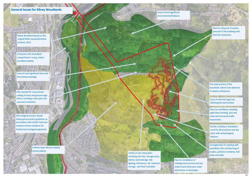
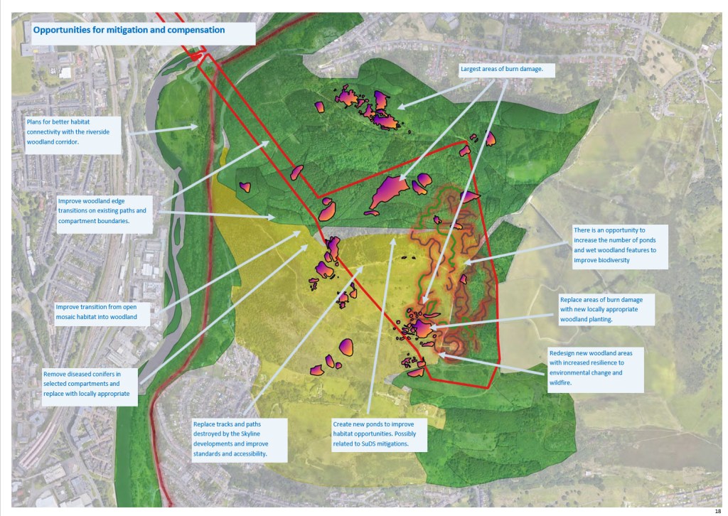
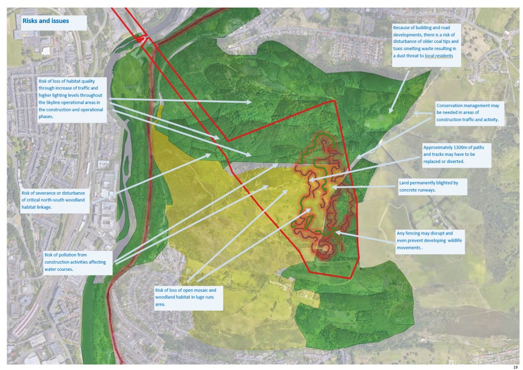
To try to fill the information gap, I created my own Ecological Constraints and Opportunites Plan (ECOP), something I used to do when I worked for the Civil Service. I was trained to follow the common standard BS42020 in structuring a document that brought together the essentials of a building plan that affected the environment.

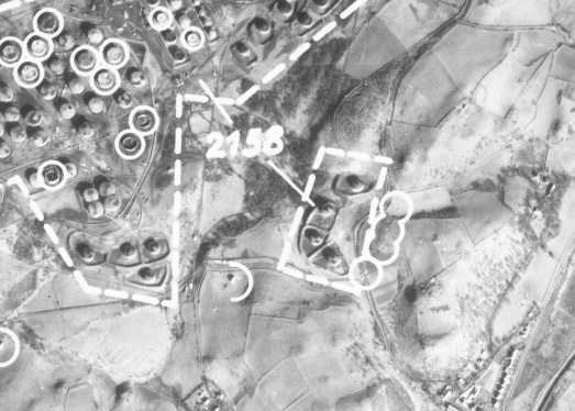
I took a photo of one of the slides on the PowerPoint shown to the meeting on the TV screen they had there. I used that as the basis for investigating the land.

Above: The original picture of the Skyline extent shown to the Environment Centre meeting in December 2022. )

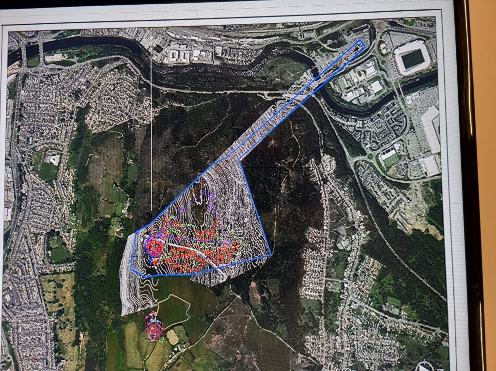
I built up an ECOP over four versions one each month (Jan -April 2023), each building on information I could interpret, but all versions were incomplete. I remember having several aggressive emails from Council staff as I asked for information. I could never work out if they were upset with me for asking or Rob Stewart for giving out vague or misleading information. We’ll never know.

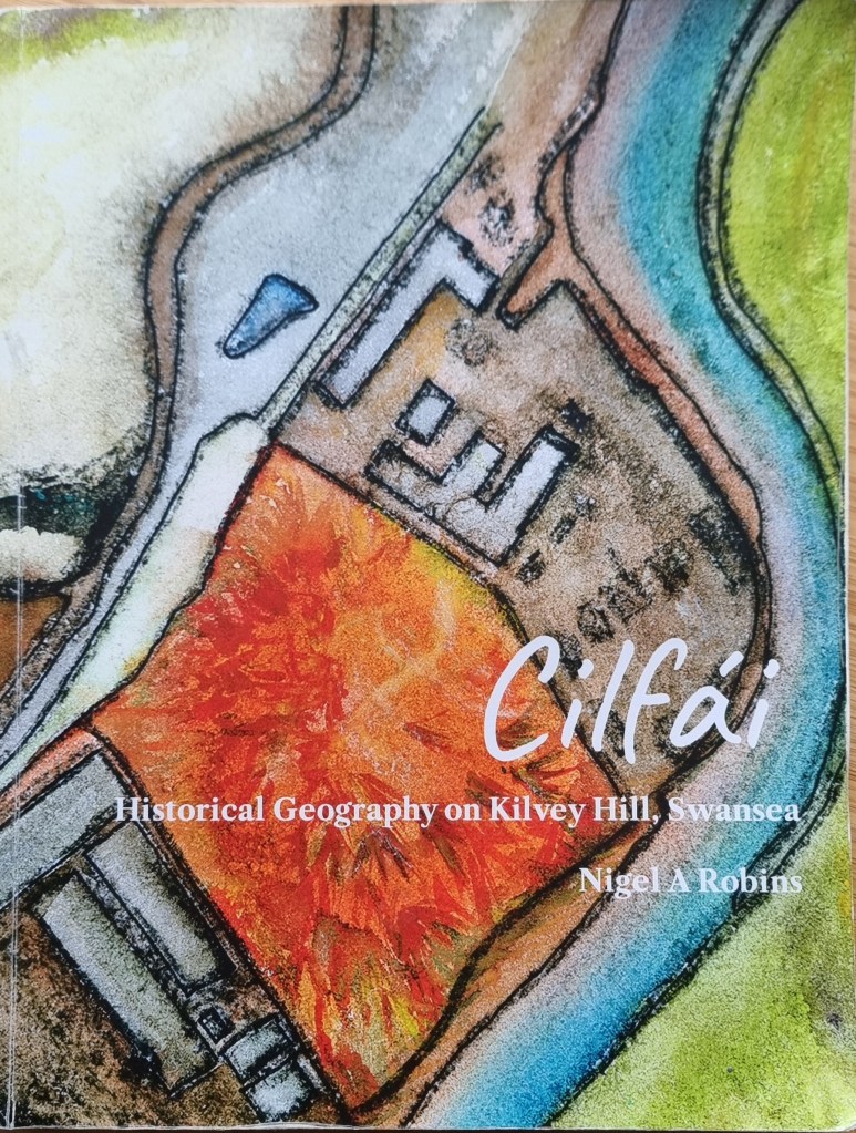
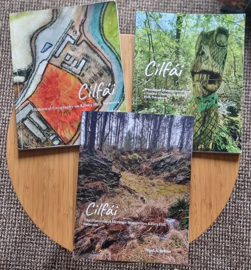
Eventually the ECOP turned into the Cilfái Trilogy of books which have formed a solid basis of information on history, woodland management and heritage for me to teacvh the landscape history of the hill.

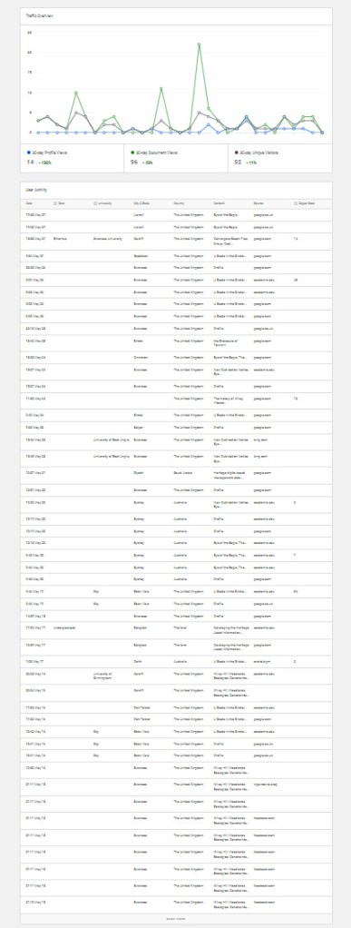
As is my habit, I posted the last (fossilised) version of the ECOP on my Academia page. What amazes me is the massive number of downloads of this document (including USA and various African countries) and local authorities. So, I guess my structure is being used as a template elsewhere. Which is great.

Below are screen shots of one of the versions…

Y Tân: A History of Destruction, Swansea, 1941 ISBN 978-7393533-4-6

This has now been reprinted as a 2025 Second Edition with some updates. I’ve also updated the copyright for AI constraints and EU product compliance details.

The first edition was an incredible success and I’d like to thank everyone who attended the illustrated talks and came on the blitz tours in 2024. I’ll be doing more walks and talks in 2025.

This book started with me trying to make sense of a part of my family’s history, so in many ways it is a work of years. I grew up as a child of the inner city of Swansea, a point that came home to me when I eventually realised that both my mother’s and father’s families lost relatives in the bombing.

The story of the loss of Jack Bowers was something I grew up with but the true significance didn’t really hit me until I became a parent myself and I lost the older members of the family. I heard stories of the war from Florence and Ethel (my grandmothers), but they were never overly keen to talk about those years. I’m grateful for the things they shared with me.

The history of the town centre, later known as Castle Gardens, is central to understanding how Swansea was destroyed.

I am so grateful to my friend Dr John Alban for his expert knowledge of the period and the many discussions we have had over the years. John’s generosity and support has been significant for so many of us as Swansea historians. I gained a deeper understanding of fire whilst working on the restoration of the Palace of Westminster (which has a unique relationship with fire itself), and I learned much from working with fire engineers on the Parliament restoration, although none of my colleagues realised I was busy applying what I was learning to the destruction of Swansea in the blitz. My lifelong friend John Andrew was particularly supportive and our long conversations so productive.

I was very privileged to be able to talk with Tony Kilmister about the courageous exploits of his mother and father, who were central to the Teilo Crescent tragedy. The Royal Engineers Association were incredibly helpful and friendly and I remember with great affection spending evenings in the Drill Hall listening to the old soldiers’ stories that put faces and personalities into the painful history of the time.

Also the wonderful support of my wife Alison who does so much to inspire and improve my writing and provide background knowledge on so many things.

Eye of the Eagle: Luftwaffe Intelligence and the South Wales Ports 1939-1941 ISBN 978-1-7393533-3-9

This has now been reissued as a 2025 Second Edition. I’ve also updated the copyright and EU product compliance details.

The first version of Eye of the Eagle was published in 1993. At that time, the research was to look at local landscape history, and British government aerial photographs were prohibitively expensive for such research, whereas, with a bit of effort, the Luftwaffe aerial surveys were freely available albeit via the record offices of the USA. As a geographer, my first instinct was to look for photographs and maps that give a first impression of a landscape before experiencing the land by walking. Since those days, a revolution in information sciences has changed so much. British record offices are far easier to engage with, and online and digital sources provide a wealth of resources and historical riches that were undreamed of in the 1990s. Combining the images with appropriate GIS/GPS systems has provided spectacular insights into ancient woodland and post-industrial recovery of land.

However, what has not changed is the research and writing techniques that underpin our discipline. This book has been written several times, only to be rewritten when new sources become available or are revealed in the improved access or digitisation of various records. Some of the many images and sources you will see here were rescued from rubbish dumps as organisations sought to ‘become digital’ in the early 2000s by throwing away ‘old’ records. Which explains their rather ‘worn’ looks.

Llandarcy showing destroyed oil tanks and near misses after the 1940 bombing raids.
One of the GWR plans of Cardiff used by thew Luftwaffe to plan their air attacks in September 1939.

Cilfái: Historical Geography on Kilvey Hill, Swansea ISBN 978-1-7393533-0-8

This has now been reissued as a 2025 Second Edition with some updates, minor amendments and some new illustrations. I’ve also updated the copyright and EU product compliance details.

This study has been heavily reliant on past teaching notes and lessons learned from students’ questions and discussions over many years. I am indebted to all of them. Grateful thanks to the staff of West Glamorgan Archives Service and the archivists at the British Geological Survey in Keyworth who allowed me to spend time with William Logan’s original notebooks. The help of experts such as Dr John Alban and Gerald Gabb has always been beyond value and they have helped me as a sounding board and unlocking further fields of expertise which ave been so valuable. The contributions and discussions with my oldest friend John Andrew on geology and the rocks of Townhill and Kilvey have been particularly inspiring. John passed away in August 2024 and I miss his help and support terribly.

The cover of Cilfái was part of a painting of White Rock I did a while ago, mainly to show the extent of the Cae Morfa Carw waste tip (the orange land). The Tawe is on the right, and the original long workhouse of White Rock is at the top.


I must also thank the staff and colleagues at Coed Cadw/Woodland Trust who, unwittingly perhaps, spurred me on to re-explore Kilvey some thirty years after I last surveyed the land in the late 1980s. All the modern mapping was completed using the open-source QGIS application which has become a central tool as a landscape historian over the past ten years. Finally, I must mention the help and support of Kilvey Woodland Volunteers. Without the passion and commitment of the volunteer body over many years, I doubt that Kilvey would be the special place it has become. As I write this, Kilvey is under more threats from the local council and developers, and I hope this little book records a few milestones in the ongoing Kilvey story rather than an ending.


The first edition of Cilfái was remarkably successful. The aim was to fill a gap in knowledge about the Hill in the constant challenge to take care of it in the face of threats of irreversible destruction from tourist developments and an uncaring local authority. There are now many more local environmental and residents groups aware of the current value of the land and the potential loss Swansea faces if the destruction begins. This book was the first of the Cilfái trilogy, the second book covered Woodland Management and Climate Change, and the third book covered the heritage features on the hill. This book was rushed into print to address claims from the Local Authority that there was ‘not much up there’. Since 2023, I’ve taken hundreds of people on walks to view the biodiversity, history, and heritage of Cilfái, and I’ve packed out numerous community centres and halls to talk about the history. Hundreds of people have been converted to the value of the landscape we may lose.

Above: A coal adit on Kilvey was left to regenerate after about 40 years of peace. Swansea Council may be seeking to destroy this land, which they consider ‘worthless’.

The Museum Model of the Castle Gardens/Ben Evans Block

One of the most remarkable items on display in Swansea Museum is the model of the Plas House and the surrounding streets from the 1820s. It was extemely useful to be able to examine the model when I was reconstructing the layout of the streets for the Y Tân book.

It is difficult to create a good quality map of the town streets until the creation of the 1852 Board of Health plans. The model in the museum is topographically corect and I was able, with the help of modern technology, fix an exact position of the Plas House and its relationship to Temple Street. Knowing the positions of these two things makes it easier to understand the construction of Ben Evans and what happened after the war, when it became Castle Gardens.

The model is on the first floor of the museum.

Above: A view of the splendid model of the castle and town centre made in the
1820s. The model has pride of place in Swansea Museum. The row of houses
coloured yellow and pink are in Caer Street and you can see the castle on the right.
Behind Caer Street you can see the ruins of the Plas House, covered in vegetation.
The types of vegetation covering the ruins are described in chapter 5.

You can but the book online here Y Tân (lulu.com)

Castle Gardens: The site of Ben Evans

Although we now know Castle Gardens as an ugly concrete space in the centre of town, that area of land has been central to Swansea’s history for centuries.

Originally part of the inner ward of Swansea Castle, the space has over the years held many buildings starting with the Plas House built in the 1300s. You can see a fantastic model of the area in Swansea Museum which was made in the 1820s. The streets that defined the Plas House block are part of Swansea’s long history. Temple Street to the north which once held the Three Lamps Inn, Goat Street to the west which held the original police station, and Caer Street to the south, which is (sort of) still there.

Pride of place has to go to Castle Bailey Street to the east which originally was a big space in front of the castle. By the 1890s, the site was the home of the various properties that made up the Ben Evans department store. Understanding the layout and contsruction of the store is an important part of understanding how it caught fire and burned so easily in February 1941.

For the book I reconstructed the various eras of building on the block to understand more about how the space was used. I used methods from the 1940s when architects and fire engineers were reviewing the incendiary attacks on Britain and looking to learn lessons to destroy German towns and rebuild Swansea after the war. Understanding Castle Gardens is a chapter in my book.

You can buy online here: Y Tân (lulu.com)

Above: Part of my reconstruction of the Castle Gardens block in central Swansea. By the 1840s, houses and shops were built on Castle Bailey Street and Caer Street. They built around the remains of the house and garden of the Plas House. Eventually, commercial pressures led to the destruction of the Plas and the construction of more houses and shops on Temple Street.
Above: A rare map of the Castle Gardens block in the 1850s.

Y Tân (The Fire): A History of Destruction, Swansea 1941

One of my longer-term projects. This originally started as a small article about the death of my grandfather, Jack Bowers. Jack died fighting fires in Castle Street on the third night of the February 1941 bombing of Swansea. It was a family tragedy and coloured the lives of my mother and aunt for the rest of their lives. My research went further and broader as I tried to understand the nature of the air attacks and what happened to people on the ground. I also looked at the history of the rubble that was left, including the history of Castle Gardens and Ben Evans the famous Swansea department store.

Here’s the blurb on the back cover:

“In World War Two, Swansea was regularly attacked by the German Air
Force. The worst attacks were over three nights in February 1941. The
bombs and fires transformed the centre of the town, and the author’s
grandfather was killed as a volunteer firefighter.
This book explores the events of the three nights, the loss of the
author’s grandfather, how the fire was used to destroy the town and the
consequences of the raids for the future of Swansea. Swansea Blitz was
an early example of a firestorm and became a template for attacks on
many European towns and cities in 1942 and 1943.

The author reconstructs the events of the three nights and includes
eyewitness descriptions from some of the people who worked to save
lives and property. The book also includes an analysis of the loss of
the Ben Evans department store and the detailed history of the land
we call Castle Gardens. With technical details of the bombs and
explosives that were used to attack the town and the history of the
bomb disposal teams that worked to save Swansea.


Based on meticulous research this fully referenced book examines the
vulnerability of the town to air attacks, the technical background of
the incendiary bombs, the events of the three nights of terror, the
ecology of the devastated town centre and the aftermath of
rebuilding.”

Details

Publication Date:Aug 5, 2024

Language:English

ISBN9781739353346

Category: History

Pages:160

Paperback Perfect Bound

Interior Color Color

Dimensions

Digest (5.5 x 8.5 in / 140 x 216 mm)

The importance of Referencing in writing

Last week, I spoke with an academic friend who was furious to find that an editor had amended one of his articles by altering the footnotes and referencing. He was understandably annoyed because it was without his permission and wasn’t even notified!

When he mentioned it, I remembered it had been done to me on several occasions. On one occasion, I queried why it had been done without reference back to me and was told it was for space saving. Enquiring further, I realised the reason was primarily that the editors had very little understanding of citations and referencing and eventually admitted that they ‘didn’t actually follow any recognised style or referencing format’. Indeed, when I looked back at a few back copies of their journal, I could see that it was true…woefully so.

In these days of Artificial Intelligence (AI) and countless automated writing tools, detailed referencing is vital. If I can’t explain where I got a piece of information from, how can anyone believe me? Even if barely 2% of my readers look up a reference to read further or verify something I have written, it is always there to be verified.

AI is making belief in the written word much harder. In my work as a consultant, I often saw colleagues prepare reports and presentations, often for considerable cost, and be totally silent on their sources. I know this was to hide the amount of plagiarism, passing off, duplication, and Wikipedia work that was often conducted as ‘serious’ research. I never did this and was often criticised for revealing my sources, usually by the people being fired whilst I retained contracts and the confidence of my employers.

The rise of fake academic papers is alarming.

AI is now being used to write all sorts of technical, legal, and medical reports and articles, and it is smart enough to generate false references and citations to support its arguments. The AI trend is devaluing knowledge and expertise and reducing confidence in what we can rely on, whether that is local history or cancer treatments.

Many others are now declining the opportunity to appear in electronic journals, and everything I research and publish is referenced. From now on, my books and longer-form research will only be published in paper form, and only abstracts will be released online. Of course, this hasn’t stopped people from individually scanning books, and I have seen electronic versions of the Cilfái trilogy already appear.

Equally, AI is an immensely valuable tool for research. I will frequently use AI tools for library searches or organising my thoughts on a topic. They are increasingly powerful and need to be used wisely.

Above: One of my Lit Map citation searches allowing me to quickly locate relevant authorities on the research topic.
Above: AI and Google at work. A report on people (and robots) searching for my writings.

Swansea: Looking at Castle Gardens, Ben Evans and the Blitz fires

Castle Gardens appears to be unlovely and unloved. I know it is the target of a proposed refurbishment ‘after consultation’. The plan I saw promises small (cheap) changes.

I grew up wandering around the original Castle Gardens in the 1960s. Chasing the army of pigeons that lived on the roofs of the Sidney Heath’s buildings. It was full of green spaces and the Sidney Heath fountain, and the covered area was always full of (to me) old men sitting and drinking. The fountain seems to now be in the gardens in Singleton.

I think this is the remains of the Castle Gardens Fountain ?

The open space originated as a ‘Garden of Rest’ site after the Blitz. (Evans 2019). It eventually (after the inevitable Swansea Council arguments!) became the open space of some grass, some paths and the fountain, which stayed until 1990 when it was obliterated for the ghastly makeover we see today.

The plot of land is fascinating. It was the site of the famous Ben Evans store and, before that, the Plas manor house. As one of the most significant urban areas of the medieval town, it may be that significant archaeology lies underneath the northern side close to where the Plas and Temple Street were.

In my latest research on the Blitz, the plot is helpful to study the impact of incendiaries on the wider town and it’s become a case study in my next book.

Understanding the site that once held Ben Evans entails delving back into the past to look for the Plas manor house and the rebuilding of Cae Bailey Street between 1840 and 1850. The maps are poor, but we do have a fantastic model of the area made in the 1840s, which is now in Swansea Museum, and Gerald Gabb has examined all the paintings and prints in his books (Gabb 2019: 199–207).

The model of the centre of Swansea made in the 1840s. Damaged in the Blitz and repaired by Bernard Morris. Now in Swansea Museum.

I’m digitising the various stages of buildings in the Castle Gardens site as part of the background for understanding the Swansea fire catastrophe of February 1941 (Alban 1994). I’m lucky in that there is a detailed survey of the area from 1852, which is the basis for establishing the area that eventually became Ben Evans in the 1890s.

Alban, J.R. 1994. The Three Nights’ Blitz: Select Contemporary Reports Relating to Swansea’s Air Raids of February 1941, Studies in Swansea’s History, 3 (Swansea: City of Swansea)

Evans, Dinah. 2019. A New, Even Better, Abertawe: Rebuilding Swansea 1941-1961 (Swansea: West Glamorgan Archive Service)

Gabb, Gerald. 2019. Swansea and Its History Volume II: The Riverside Town (Swansea: Privately published)

Above: My digitising of 1840 to 1852 properties that were Castle Gardens. The grey block at the top of the image is the location of the Plas manor house. The area was heavily resculpted after 1945 to create Princess Way and the David Evans shops.

Housing history in Swansea

I’m taking a University class out tomorrow to look at some industrial housing history around Hafod and Landore. Housing history was the central theme of my research in the 1990s amd I must have surveyed and mapped hundreds of Glamorgan houses as I worked to understand industry, landscape and the housing needs of the early coal and metal industries.

Shape is one of the most important features of early (pre-1919) houses and it became a bit of a party trick when I could guess for other people the decade in which their original house was built. Although many of Swansea’s earliest industrial houses were swept away in the 1920s as part of slum clearance, quite a few of the classic examples still remain. Beyong the boundary of the original County Borough of Swansea, neighbouring local authorities did not clear their older houses and many survive in villages, cwms, and valleys near the pits and factories they served.

These are the handouts fr0m ‘Housing History 101’ from my teaching days. I suppose these types of documents (and clip art!) are history themselves now LOL.