Geoheritage is now becoming a broader term for our geographical and geological features that have significant scientific, educational, cultural, or aesthetic value. Swansea has an important place in the history of geological exploration and the development of the Welsh coal industry.
People who have participated in my many guided walks on Kilvey will already be aware of the value of the Kilvey Geoheritage sites and the contribution they make to the Biodiversity and Geodiversity of Swansea.
Globally, October is a month of celebrating and recognising the importance of the rocks and landscape underneath our feet. Swansea has more than most towns to be mindful of, as it is built on over a thousand years of coal mining history.
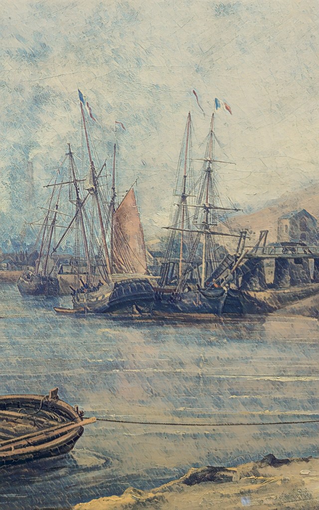
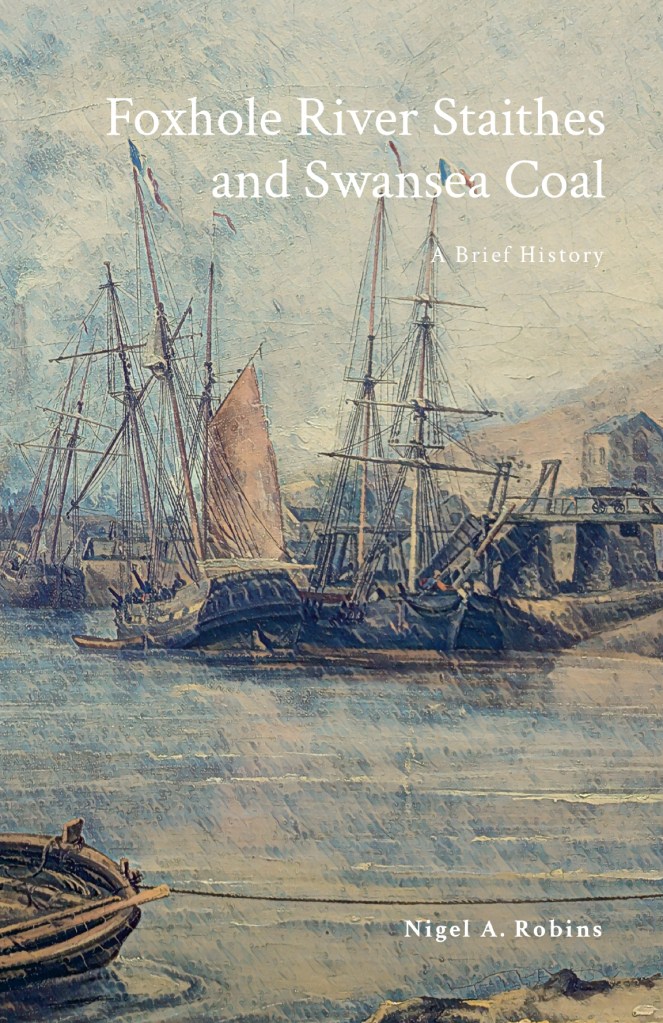
Above: Foxhole Coal Staithes in the 1840s.
Following on from my recent book on Foxhole and the history of Swansea Coal, I’ll be giving a few guided walks and talks on broader aspects of Swansea’s incredible Geoheritage and Geodiversity.
On 4 October, I’ll be talking about the history of Swansea coal and the special place Foxhole on Kilvey has in the history of Welsh coal mining. My talk will be at Swansea Museum as part of the RISW and the Historical Association’s History Day 2025. I’ll also have copies of the Foxhole history book at a discounted price.
On 6 October, as part of UNESCO’s # InternationalGeodiversityDay, I’ll be leading a walk around the geological features of Kilvey Hill and explaining the unique place in Swansea’s history that Kilvey holds. The geological features of Kilvey have long been regarded as obscured or destroyed, but many have survived against all odds. Come with me and walk the land that was explored by Geology’s most famous local coal pioneers, William Logan and Henry De la Beche. Tickets will be available shortly. I’ll advertise them via Facebook and Eventbrite.
On 8 October, I’ll be at the Friends of Penllergare monthly meeting at Llewellyn Hall in Penllergaer. I’ll be talking about ‘Penllergare, Henry De la Beche, and early Geology in Swansea’. Lewis Weston Dillwyn was often at the centre of scientific and cultural events in Swansea. He was particularly prominent in the recognition of Swansea as a centre of research in the emerging science of Geology and the first understanding of the South Wales coalfields.
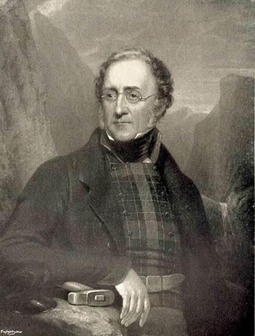
Above: Henry De la Beche. Pioneer geologist.
I’ll be doing a few more walks and talks throughout the month, and I’ll post here to let people know. If you want to know more contact mew for details.
I’ll also have my bookshop of all my current books in print at the History and Heritage Fair at the National Waterfront Museum on 27 September 2025.
I was particularly struck by a recent opinion piece in The Lancet Planet Health on the links between human health and wellbeing and diverse nature.2 It’s an approach that remains at the centre of my use of Kilvey/Cilfái as a landscape for teaching. Early on, I could see that an overemphasis on biodiversity to the exclusion of other aspects of the environment would inevitably lead to a partial appreciation of the landscape.
Subscribe to continue reading
Subscribe to get access to the rest of this post and other subscriber-only content.
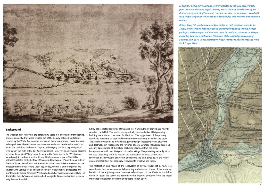
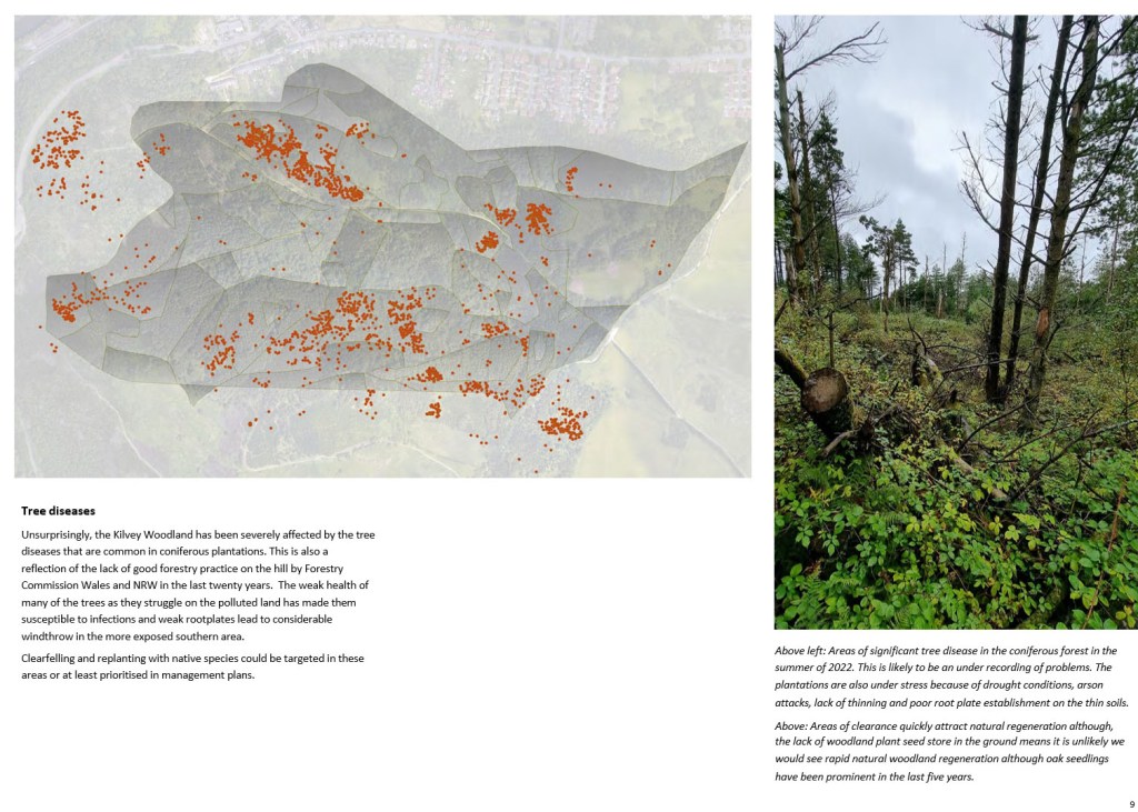
In the autumn of 2022, the local Council announced their plans to remodel the ancient Kilvey Hill landscape for a new tourism development, which would destroy the traces of thousands of years of human habitation and endeavour. The impending destruction led me to do what I could to record the history, ecology, biodiversity and Geoheritage of what is a significantly under-recorded landscape with considerable potential for education, well-being and climate change management.
Documenting the history and biodiversity was relatively straightforward, albeit a challenge to perceptions regarding a large area of land that many people see but few have experienced and even fewer understand. I remember one comment from the local authority about ‘there is nothing up there’. A comment I later understood as a self-serving phrase to make the destruction and loss more comfortable for planning permissions.
Above: The thinly bedded sandstones of sandstone on Kilvey are part of a broad range of types of structure on Kilvey, along with massive beds heavily used for building stone and the bituminous coal seams that were so important to early Medieval Swansea.
I suppose my perceptions were different, having had the advantage of a geological education at school and undergraduate level, including a hectic month of field mapping coastal regions of the Isle of Wight back in the day. I hadn’t appreciated how much of that had stuck with me until I needed to explore the Geodiversity of the Hill through documents, fieldwork and the wonderful archive of the British Geological Survey.
The fact that the natural heritage of any country includes its geological heritage is now slipping away from us. The wonderful naturalists’ clubs of the early twentieth century, such as the Swansea Scientific and Field Naturalists’ Society, were a broad church to all aspects of nature, including geology. But they have disappeared in the swing towards wildlife rather than general nature conservation, which has permanently obfuscated much of our wonderful Welsh geological heritage. The process accelerated as Naturalists’ Societies changed their names to Wildlife Trusts.
The collapse of geology as a subject deemed worthy of learning and the dissolution of the geological part of the National Museum for Wales have meant that describing the significance of geological sites has become challenging, as basic literacy in the nature of rocks and the landscape is in freefall.
Geoheritage and Geodiversity featured strongly in my first book on the history of Cilfái, not least because it was good history as well as good geology (Robins 2023a). I sought to highlight the significance to local heritage of the geology by separating ecology, biodiversity and climate change into the second Cilfái book (Robins 2023b). However, I felt my treatment of Geoheritage in the first book was not enough. I included a more substantial piece on Swansea’s coal history in my book on the Swansea Foxhole Coal Staithes, but the rich history of William Logan, Hendry de La Beche and Aubrey Strahan clearly deserves more (Robins 2025).
‘Every outcrop has the potential to be great’ (Clary, Pyle, and Andrews 2024) was an opening line to a recent special publication from the Geological Society. It’s a great opening line, and it sets a very positive note for a lively discussion on Geoheritage on a landscape scale. It’s a sentiment that is less positively upheld in Wales where our process of listing or recording sites of geological interest is haphazard and starved of interest and funds.
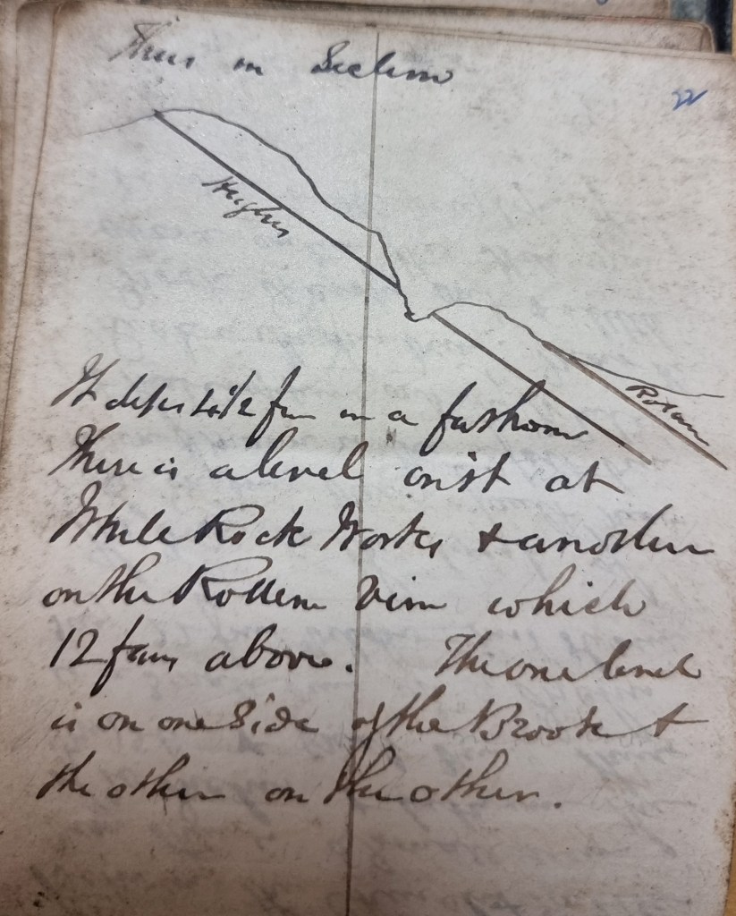
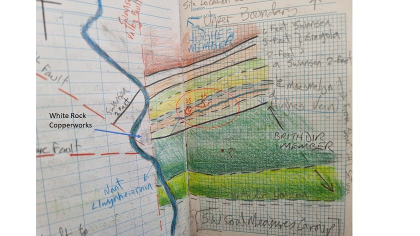
Above: An extract from one of William Logan’s many notebooks from the 1830s. Logan made regular visits to the outcrops above White Rock as he sought to understand stratigraphy and dip of the beds for coal exploration.
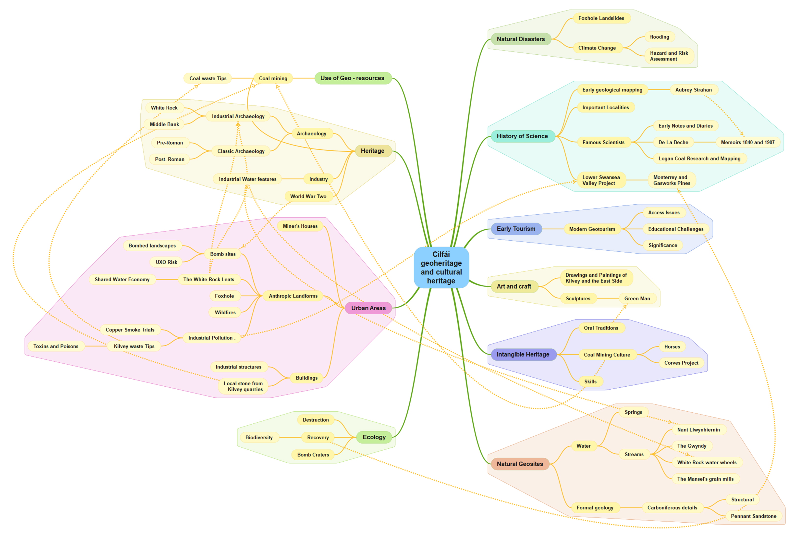
Nevertheless, the listing of a Kilvey site visit on the coming UNESCO International Geodiversity Day is a good opportunity to explore and reassess local Geoheritage. In preparing information for the International Geodiversity Day, I was particularly struck by a recent article linking Geoheritage and Cultural Heritage (Pijet-Migón and Migón 2022). The authors have introduced a model of themes at the Geoheritage-Cultural Heritage ‘interface’. It’s a very useful summary of what to explore or be aware of when revisiting geological sites. It helps move forward from traditional geological guides and texts (Owen 1973), which, although very useful, need to be modernised and broader in scope and engagement for a new generation.
Although the Pijet-Migón model doesn’t fit everything, for example, it can be broadened to explore the link between Biodiversity and Geodiversity, it is very useful. Here’s the Cilfái Geoheritage Landscape filtered through an amended model:
Clary, Renee M., Eric J. Pyle, and William Andrews. 2024. ‘Encompassing Geoheritage’s Multiple Voices, Multiple Venues and Multi-Disciplinarity’, Geology’s Significant Sites and Their Contributions to Geoheritage, no. Special Publication 543, pp. 1–7, doi:10.1144/SP543-2024-34
Owen, T.R. 1973. Geology Explained in South Wales (David & Charles)
Pijet-Migón, Edyta, and Piotr Migón. 2022. ‘Geoheritage and Cultural Heritage – A Review of Recurrent and Interlinked Themes’, Geosciences, 12.98, doi:10.3390/geosciences12020098
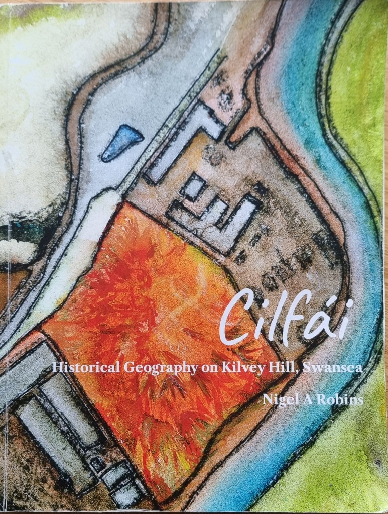
Robins, Nigel A. 2023a. Cilfái: Historical Geography on Kilvey Hill, Swansea (Nyddfwch)
——. 2023b. Cilfái: Woodland Management and Climate Change on Kilvey Hill, Swansea (Nyddfwch)
——. 2025. Foxhole River Staithes and Swansea Coal (Nyddfwch)
In researching the geology of Kilvey Hill, several issues quickly come to light.
The first is how little geology is actually being taught or even followed as a hobby any more. This is quite remarkable given the massive part Swansea’s geology has played in the history of the town. Swansea’s underlying coal resources were a massive factor in the development and growth of the eighteenth-century town. Without coal, there would have been no copper smelting, and Swansea would probably have remained the ‘Brighton of Wales’ (Boorman 1986). All the more remarkable when you consider that geology was an immensely popular subject for study in Swansea from the 1830s, and a century later, a large part of the University College of Swansea (Owen 1973; 1974). The geology of Kilvey became a training ground for William Logan when he taught himself about Swansea coal and rocks in the 1830s. Some of this will be a central theme in my guided walks for UNESCO Geodiversity Day in October.
The rocks of Kilvey contain a mass of plant and animal traces from the past. Understanding these past ecosystems and biodiversity allowed us to understand and exploit the coal reserves of under Swansea and the wider South Wales Coalfield. These rocks overlie the Tormynydd Coal Vein on the seaward side of the hill above Port Tennant.
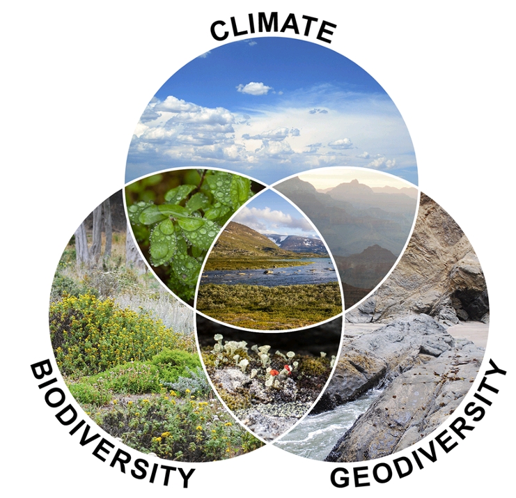
Although people are now fully aware of the importance of biodiversity to our lives, less is appreciated about the non-living side of the equation — the Geodiversity of the underlying rocks and soils. Geodiversity is the foundation of the ecological life on the hill. The underlying soils, waste tips, streams, and geological features all influence the recovery of life after the cataclysmic pollution that killed everything on the hill in the nineteenth century.
The links between Geodiversity, Biodiversity, and Climate. Human activity has fundamentally altered the relationship between all three elements. (from an original in Tukiainen et al. 2023).
Biodiversity, Geodiversity and Climate are all interlinked to give us the environment we live within, or are responsible for (Tukiainen, Toivanen, and Maliniemi 2023). Kilvey’s ecosystem was destroyed by industry, coal mines destroyed the water table, and the recovery process has been long and uncertain, but in some places spectacular. It remains a tragedy that some of the recovered green areas of the hill will shortly be destroyed again by the local Council.
Boorman, David. 1986. The Brighton of Wales: Swansea as a Fashionable Seaside Resort, c.1780-1830 (Swansea Little Theatre Company)
Owen, T.R. 1973. Geology Explained in South Wales (David & Charles)
—— (ed.). 1974. The Upper Palaeozoic and Post-Palaeozoic Rocks of Wales (University of Wales Press)
Tukiainen, Helena, Maija Toivanen, and Tuija Maliniemi. 2023. ‘Geodiversity and Biodiversity’, in Visages of Geodiversity and Geoheritage, Special Publications, 530 (Geological Society of London), pp. 31–47
The work here was added to original surveys carried out in the 1980s, and a comparison with photographic records allowed a visual check of the structure’s deterioration and environmental changes. A review of the geology of the structure’s building materials could also be carried out, which revealed distinctive contrasts between this structure and other post-1737 structures and walls nearby.
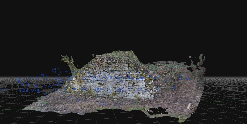
I’m really pleased that this small project is now starting to yield results! The first delivery was a series of scans and interpretations of some rare dock structures on the banks of the River Tawe. Some of the structures are scheduled ancient monuments, but the oldest and rarest are not!
The brief for this structure was a cheap and accurate photogrammetric survey at the lowest cost, allowing for interpretation and enhancing the historical information from earlier work and new research. The requirement was cheap, quick and accurate, which meant no expensive drone or landscape surveys.
Above: An early eighteenth-century coal staith remains in the Swansea Valley.
The work here was added to original surveys carried out in the 1980s, and a comparison with photographic records allowed a visual check of the structure’s deterioration and environmental changes. A review of the geology of the structure’s building materials could also be carried out, which revealed distinctive contrasts between this structure and other post-1737 structures and walls nearby.
There is still much to do, including costing the project and leveraging the technology more effectively on little-known structures in the area.
The concept of quick and cheap photogrammetry is now proven, and simple work like this can be comparable to expensive archaeological surveys, which cost far more, often a hundred times more than current archaeological firms charge.
As I said earlier, the purpose of this project was a proof of concept on using photogrammetry as cheaply as possible to allow quick and accurate reconnaissance and survey of small features that generally would not be investigated or be too expensive to survey using current high-cost photogrammetry, drone and lidar techniques.
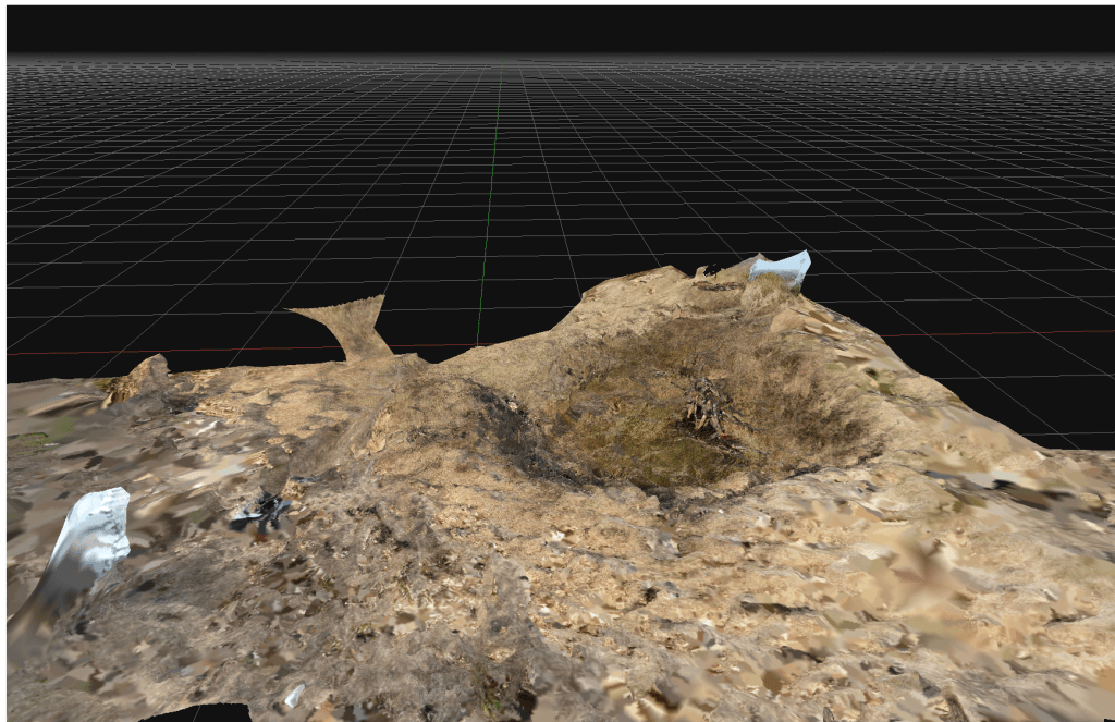
This example is a bomb crater on Kilvey Hill. The crater was most likely created in the January 1941 attack on the town. The crater is from a large calibre bomb (possibly 250kg) that has penetrated some way into the soft, marshy ground and then detonated.
In the 84 years since the detonation, the crater has softened with the crater lip mostly eroded. The crater frequently fills with water and has a different botanical nature to the surrounding grassland. This crater is a local biodiversity hotspot, allowing moisture to be present all year round and providing better protection from excessive temperatures. A large pine in the centre of the crater has died providing a reservoir of dead wood.
Above an extract from an initial 3D model of one of the Kilvey bomb craters, 2025.
The concept of quick and cheap photogrammetry is now proven, and simple work like this can be comparable to expensive archaeological surveys, which cost far more, often a hundred times more than current archaeological firms charge.
My new work is uncovering the history of the early geologists and explorers of the Welsh coalfields.
Although coal mining has been ongoing in the Swansea area for at least a thousand years, the uncertainty about what coal actually is lasted until the 1920s.
In Swansea, the exploration of our coal seams began in the eighteenth century, but it was in the 1830s that pioneer geologist William Logan first started to examine the coal and sandstone layers on Kilvey and Town Hill to understand the physical arrangement of coal seams. When Logan met Henry De la Beche (sometime in 1833), the quality of Logan’s research was instantly recognised as being central to the geological mapping of the Swansea district and the wider Welsh coalfields.
The debates over whether coal was a rock or a mineral continued throughout the early 1800s, and early geologists struggled to understand what coal was and how it was created.
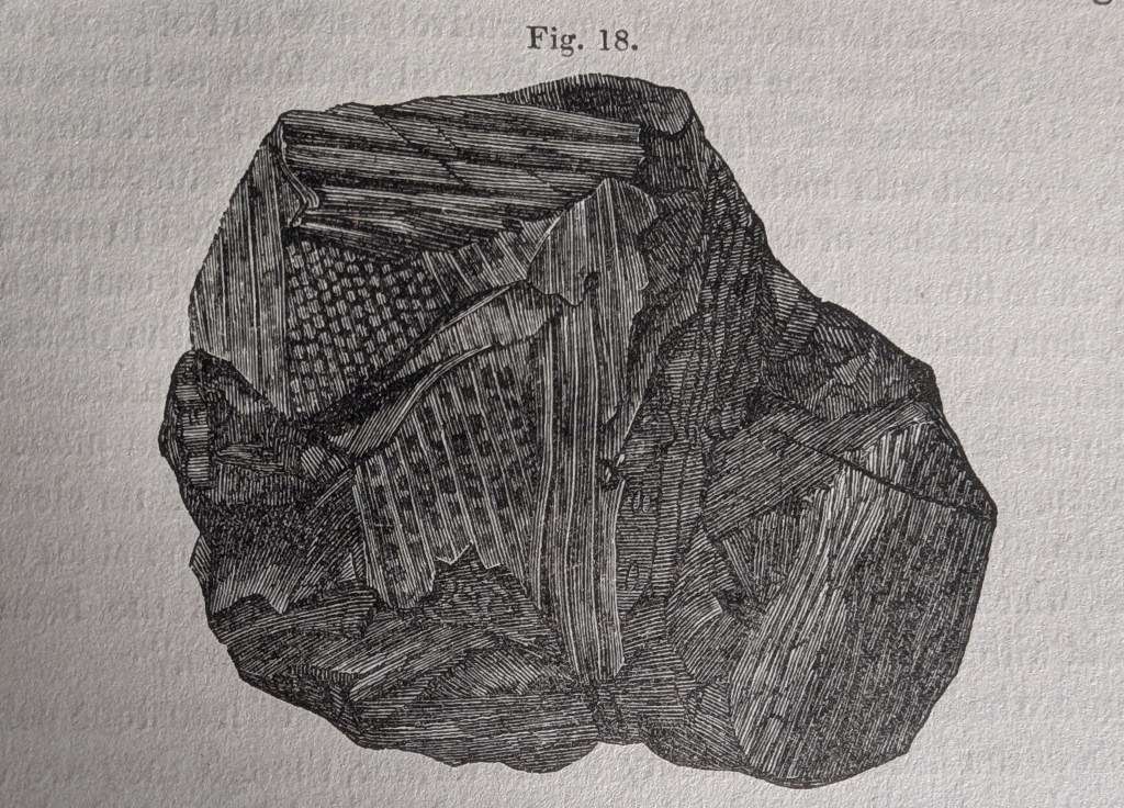
Below is a drawing from 1841 showing the complex plant structures within a piece of local bituminous coal. Close examination of coal gradually revealed the incredible numbers of plants and ferns that make up the millions of tons of coal that were exported from Swansea docks.
Above: A wonderful illustration of a piece of coal showing the plant structures inside the seemingly black mass. A closer examination of coal unveiled the rich plant life that existed over 300 million years ago. This piece was drawn in 1840 by a ‘Miss Woods’ and included in the landmark geological paper by Henry De la Beche that described coal and sandstone in the Swansea area.Above: A similarly-sized piece of coal from the veins on Kilvey Hill above White Rock.Above: The first map of the coal seams of Swansea from 1842. The white lines are the faults and cracks in the rock mapped by William Logan in the 1830s.
The surviving coal-related heritage features are listed in the third Cilfái book. Available here.
In Swansea, as the anniversary of the February 1941 bombing raids approaches, interest in the Blitz always increases.
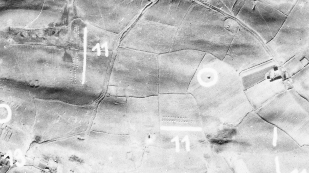
Kilvey Hill has many bomb craters across its southern part and into the woodlands near Pentrechwyth. Most craters date from September 1940 to February 1941. The German Air Force didn’t aim at Kilvey Hill; it’s just that the bombs that were intended for the docks missed and ended up on the hill. Bomb craters in town were quickly filled in, but craters on the hill were left and still survive today. A few have filled with water and have become biodiversity hotspots.
Above: bomb craters and anti-landing defences on the top of Kilvey Hill as identified by German bomber aircraft in February 1941. The anti-landing trenches are marked with ’11’ and a white line.
Kilvey also has a series of ditches and banks across the top, which were hastily constructed to prevent German soldiers from landing on the Hill in gliders. It was a definite threat, and my reconnaissance research confirms that the Germans had evaluated the usefulness of the Hill as a landing ground if they ever invaded. They survive as a poignant reminder of how real the threat was in 1940. The Council/Skyline development will destroy some of the banks, breaking a remarkable historical link between the darkest days of World War Two and our present day. It is ironic how so much is made of the disappeared Swansea copper industry in Landore is revered, but so much more recent and relevant history is ignored by Swansea Council.
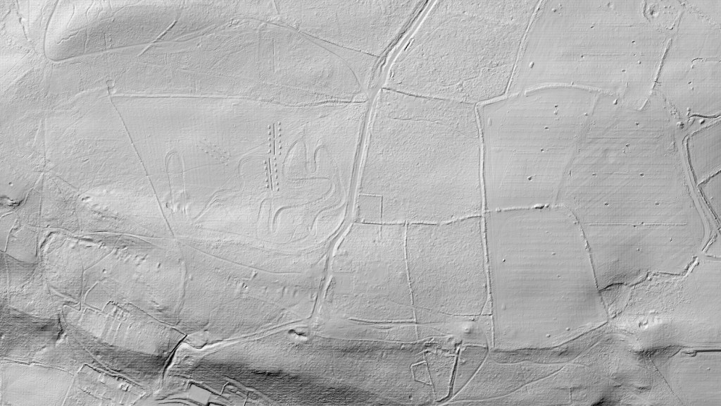
Above: A modern Lidar image of the top of Kilvey Hill showing the anti-landing trenches as they exist today as little square hillocks either side of deep trenches. They would have made landing by glider very dangerous or impossible. The flat part of the hill top was particularly attractive as a landing ground.. Morris Lane runs from the top to the bottom of the image and is seen as a series of earth banks.
Above: The top of Kilvey Hill today. Bomb craters in red, Glider defences in Red.
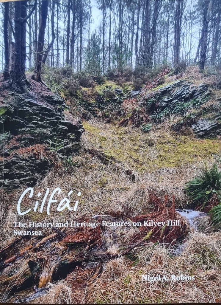
If you want to know more about all of the archaeological features on Kilvey Hill, they are listed and described in the third Cilfái book available here.
Cilfái: The History and Heritage Features is a 100-page illustrated book of all the historic features on the hill.
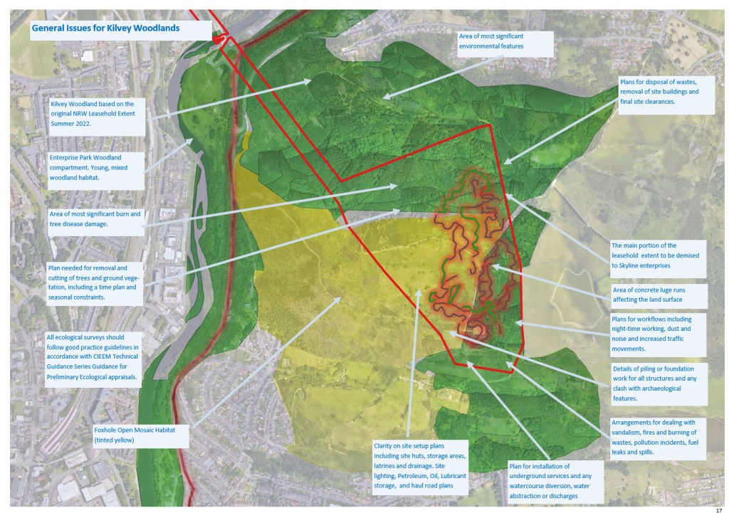
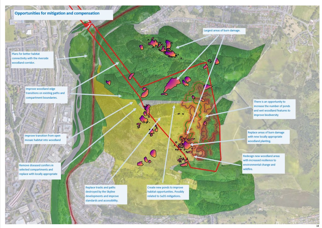
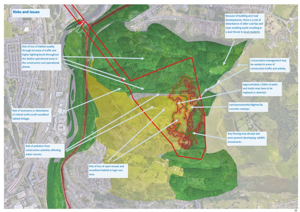
In December 2022, several senior councillors and council planning staff met in the Swansea Environment Centre with a group of concerned local people about the proposed Skyline developments on Kilvey Hill. The meeting had been prompted by the leak of information concerning a clandestine operation by Council staff to assemble a portfolio of landholdings on Kilvey Hill, which was to be leased to the Skyline investment company. Some of the land was not owned by the Council, and the authority had made strenuous efforts to obtain the land, not least because key parts of the Skyline development were planned to be built on the top of the Hill. The Council presented a series of rather mendacious arguments and ‘mistruths’ describing why they think they should acquire the land for no charge.
The meeting kickstarted a series of legal events about the unowned land and the broader picture of how the Council were dealing with the entire hill. Controversies over legal entitlement and determining a 999-year lease originally made to the Forestry Commission in 1970 abounded. The legal melee was made even worse by revelations that the hill was a designated quiet area, that there had been inconsistencies in how open access land and footpaths were being managed and a further deterioration in relationships between the Labour Council and local residents. If indeed, such a thing was possible.
The Council Leader(Robert Stewart) promised to ‘share as much as we know’ about the scheme. However, it turned out that he didn’t actually know too much, although he was obviously unwilling (and unable) to share what he did know about dealings inside the Welsh Government, an unfathomable business plan, and millions of pounds of public money being donated to a private-sector tourism venture.
I thought the meeting went as well as could be expected. Which is to say it didn’t go too well. How could it have when the questions (the good, bad, and ridiculous) were batted away with a flourish of ‘it’s too early for that’ or ‘we don’t know yet’. As the atmosphere deteriorated, Stewart descended into the understandable tactic of making stuff up, such as saying a council ecologist had been appointed, all pathways had been comprehensively mapped, and Ecological Impact Analysis had been completed, and a gradual awareness among the audience that this wasn’t a proposal in its early stages, but a carefully planned campaign of several years since local tourism consultant Terence Stevens had come up with the idea. Perhaps Terry got the idea when he became an officer of ‘Skyline Luge Sheffield Limited in 2018.
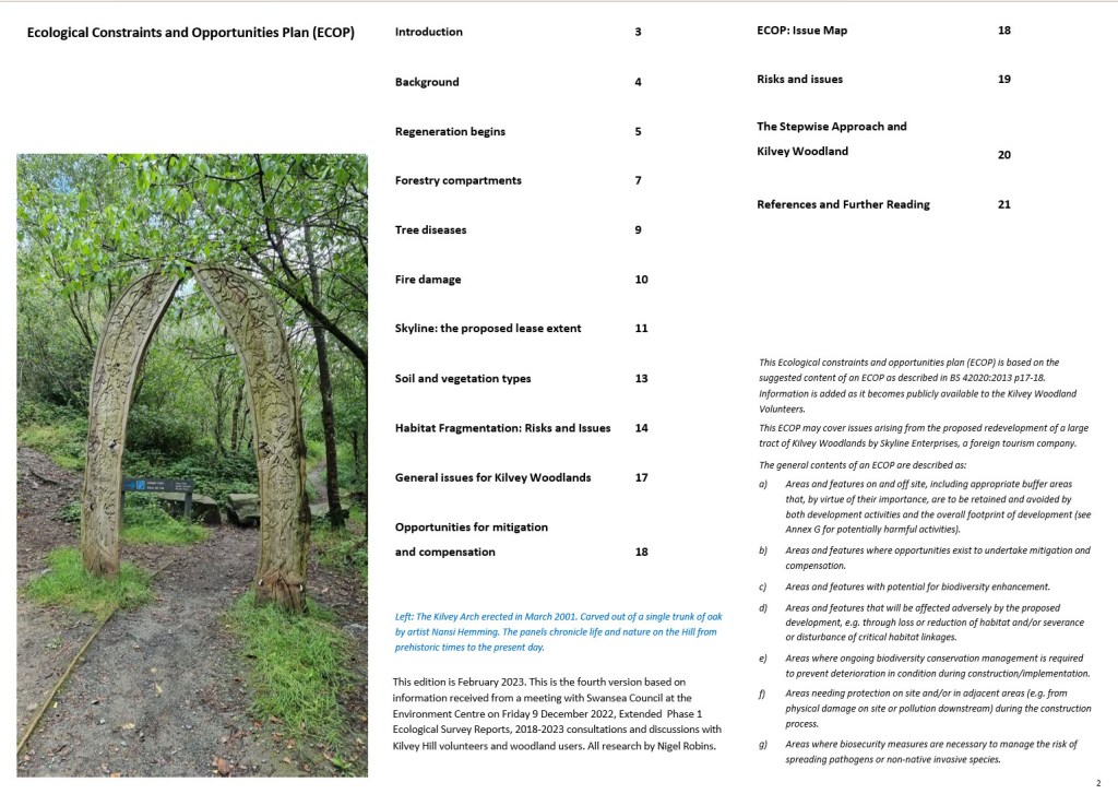
To try to fill the information gap, I created my own Ecological Constraints and Opportunites Plan (ECOP), something I used to do when I worked for the Civil Service. I was trained to follow the common standard BS42020 in structuring a document that brought together the essentials of a building plan that affected the environment.
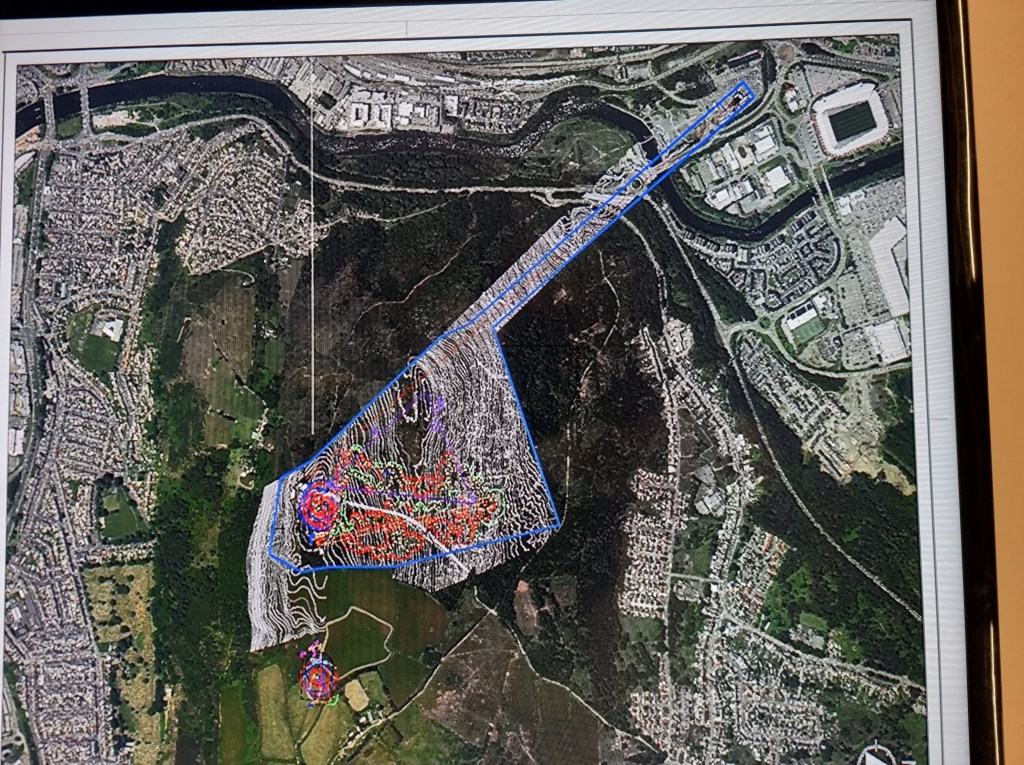
I took a photo of one of the slides on the PowerPoint shown to the meeting on the TV screen they had there. I used that as the basis for investigating the land.
Above: The original picture of the Skyline extent shown to the Environment Centre meeting in December 2022. )
I built up an ECOP over four versions one each month (Jan -April 2023), each building on information I could interpret, but all versions were incomplete. I remember having several aggressive emails from Council staff as I asked for information. I could never work out if they were upset with me for asking or Rob Stewart for giving out vague or misleading information. We’ll never know.
Eventually the ECOP turned into the Cilfái Trilogy of books which have formed a solid basis of information on history, woodland management and heritage for me to teacvh the landscape history of the hill.
As is my habit, I posted the last (fossilised) version of the ECOP on my Academia page. What amazes me is the massive number of downloads of this document (including USA and various African countries) and local authorities. So, I guess my structure is being used as a template elsewhere. Which is great.
Henry De la Beche and William Logan, between 1836 and 1841, conducted considerable research on the hills of Town Hill and Kilvey (Cilfái) in Swansea. Understanding the dip of the sandstone beds and the coal veins that ran through the rock helped both men understand the relationship between the Pennant Sandstone and the coal seams that Swansea was built upon. Kilvey has a coal mining history extending back at least a thousand years.
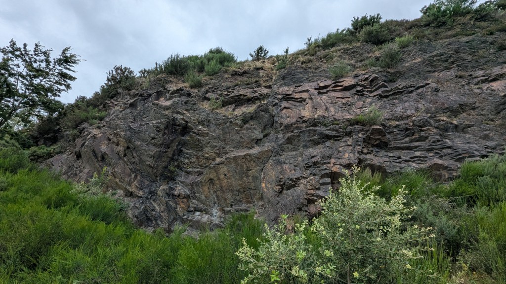
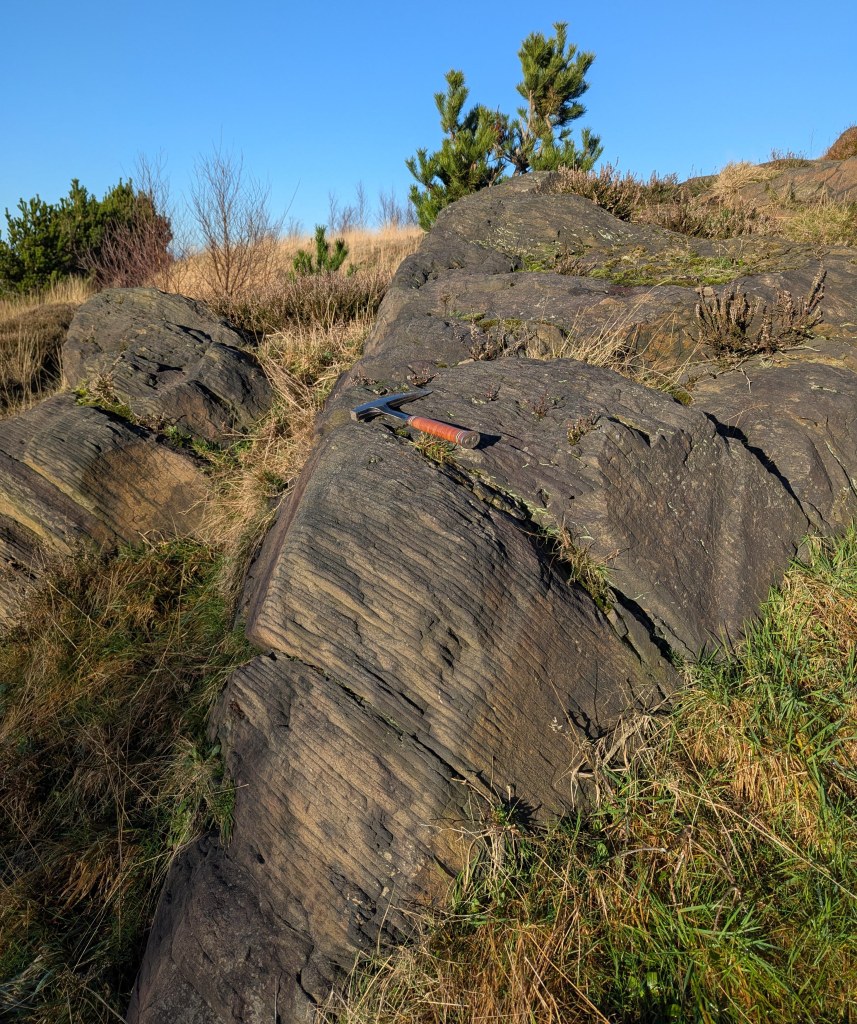
Above: A rock exposure on the southern slope of Kilvey last week. I took some record shots of the geology because this lies within the Swansea Council Skyline threatened area and it may be destroyed.
This exposure of weathered sandstone would have been examined by William Logan and both men would undoubtedly have discussed it as they worked to understand the more complex geology of Town Hill and northern Swansea. You can see the rock here dips down. In fact, it dips at about forty degrees to the north, which means that coal seams exposed on the surface on Kilvey would be hundreds of metres underground by the time you reached Morriston. Beche and Logan were trying to understand how and where to find those deep coal veins to allow better locations for new coal mines.
The layers of sandstone and siltstone are very thin here, and centuries of atmospheric pollution have highlighted the separate layers. Other parts of Kilvey have thick beds of stone used to build the Prince of Wales Dock and the Port Tennant houses.
Above is my sketch map of Kilvey showing the sandstone and coal veins as De la Bech and Logan would have seen them. The rocks in the picture above are part of the ‘Brithdir Beds’.
My next book is about the work of these two men and how they worked to understand the veins of coal that were so important to Swansea in the nineteenth century.